
At the Marina:
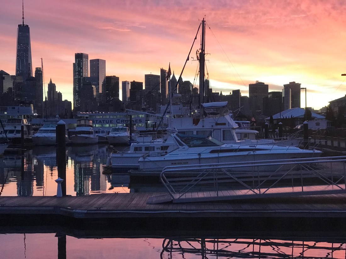
We are still here at Crystal Point Marina in Point Pleasant, NJ. It’s a rainy day – perfect for writing a blog update.

Correction, I think the marina’s official address is in Brick, NJ but it’s right on the town line. While we wait I am catching up on “The Walking Dead” and “Mr. Robot” while Kelly is watching “Blue Bloods”.

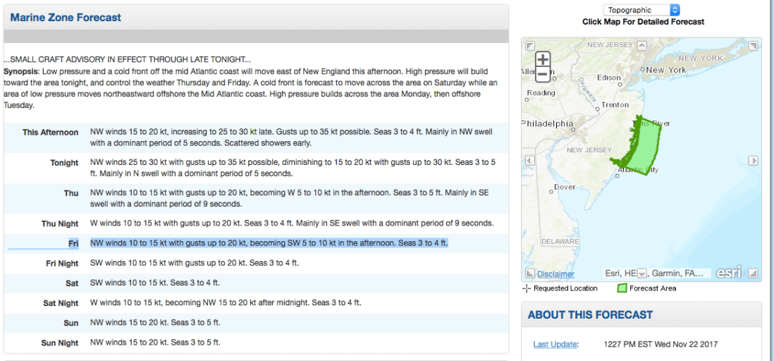
We are waiting for a weather window to proceed south to the next leg of our journey – Atlantic City, NJ. The NWS Marine Weather Forecast is showing Friday @sunrise to be our best bet.
If you want to feel like you are on the water with your VHF radio tuned to the WX channels (first 5 or so channels on a VHF Marine Radio) check out this live stream of the Tom’s River NWR Station
NOAA Weather Radio Frequencies |
| 162.400 MHz (WX2) |
| 162.425 MHz (WX4) |
| 162.450 MHz (WX5) |
| 162.475 MHz (WX3) |
| 162.500 MHz (WX6) |
| 162.525 MHz (WX7) |
| 162.550 MHz (WX1) |
| Channel numbers, e.g. (WX1, WX2) etc. have no special significance but are often designated this way in consumer equipment. Other channel numbering schemes are also prevalent. |
I feel like all the other “Snowbirds” have left before us and I am like the main character of the book my mother would read to me, “The Poky Little Puppy”. She would joke that I was a “lollygagger”. I suppose it’s my right as the last-born.

Snowbirds:
Snowbirds go south and there is more than one route to take. If you have a “Blue Water” boat and enjoy open ocean you may simply wait for a weather window and set a rhumb line straight from Newport, RI to Bermuda. This route is what the sailors of the bi-annual Newport to Bermuda sailboat race take. From Bermuda, its due South straight to St. Thomas in the Caribbean.

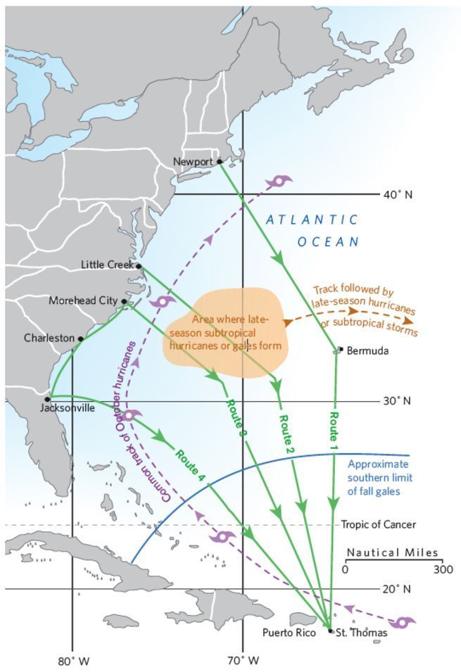
This route is only taken by larger sailing vessels and long-range stabilized trawlers such as a “Nordhavn”. Speaking of Nordhavn Yachts… in 2011, I flew down to Jacksonville, FL to purchase a Nordhavn 43. The marine broker met me at the boat which was “priced right” but as soon as I toured the vessel it was clear that she had not been properly maintained. Maybe in the future?

While we initially looked at buying a blue water trawler we realized that it did not match the type of cruising that we would be doing. We settled on a long-range trawler that was perfect for the kind of coastal cruising that we do. Coastal cruising means that you generally cruise from one port to the next never exceeding 10-12 hours at the helm. Blue water cruising means 24-7 motion with 3 hours “watches” while the other crew are sleeping in their bunks. We settled on a North Pacific Yachts 43 (45 LOA) with a raised pilothouse design and many options that we hand selected. I will save the details for an upcoming blog post about the boat itself.
Weather:
When you become a full-time cruiser you start to focus your efforts on learning more about weather. You find yourself spending a lot of time on the NWS (National Weather Service) Marine Weather Forecast website learning about all the information that it can give you. Not just forecasts but real-time observations from ships and weather buoys.
http://www.nws.noaa.gov/om/marine/home.htm
from the link above, you can select from a graphical map, the coastal forecast for the “zone” that you are in. The coastal forecasts are broken up into small rectangular sections of coastal waters that are roughly 20 miles on most sides. There is an offshore forecast for fisherman who fish the “Canyons” which are the deep underwater valleys that you see when you look at a bathymetric chart that shows the underwater topology (sea mounts and valleys).

There are also inshore forecasts as well that show the weather inside the bays. I have always had a keen interest in meteorology and understanding weather. I was smitten with weather the very first time a meteorologist came to give a lecture at UMB (Umass/Boston) and I swear every other term I needed to lookup the meaning. More recently, I signed up for a 2-day “Marine Weather Workshop” at the annual Newport RI Boat Show. I imagined that the class was going to talk about how to read the weather by looking at the skies around the boat. I was thrilled when it turned out to be a much more science based talk about wet & dry adiabatic charts and surface pressure charts built from daily weather balloon launches, etc.
The presenter was Lee Chesneau and you can find his Marine weather page here.
I’ll post more about weather as we go and maybe spend some time talking about the many different aspects of understanding weather. For now, my plan is to shelter-in-place (unfortunately, that word has a more recent meaning) and wait for the northerly winds that often follow a cold front.


You must be logged in to post a comment.