We had a quiet night on anchor in the Alligator River. Our anchor spot was just off the ICW and was an “easy in” and “easy out” in the morning. Note: some anchoring spots can have shallow or tricky entrances.
The sunrise was amazing.


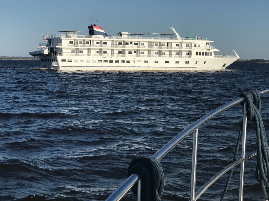
We had no sooner got through the Alligator River Swing Bridge and we hailed the large cruise ship, Independence, coming up on our stern. The captain was very friendly and thanked us for giving him exclusive use of the narrow channel.
MV Independence uses AIS just like us so it was easy to acertain their ship’s name and hail them directly. I simply let the captain know that I saw they were going to overtake us and stated we would manuver to starboard and allow them exclusive use of the entire channel for a “2 whistle pass”.
As the channel got narrow we had to get in line behind this sailboat who did not seem to have their VHF radio on. (repeated hails from us and the Alligator River Swing Bridge with no response). On the ICW you must monitor channel #16 (the international hailing channel).

Channel 16 (156.800 MHz) – Distress, safety and calling
Channel 13 (156.650 MHz) – Intership navigation (bridge-to-bridge)
Channel 70 (156.525 MHz) – Digital Selective Calling
DSC Discussion (skip this technical section if you like)
CH 70 or DSC or Digital Selective Calling is a new technology that uses EM wave pulses on channel 70 to send digital (1s and 0s encoded in electromagnetic pulses over a radio wave transmitted on channel #70’s designated frequency)
This channel is not for human voice transmission but for ships continually broadcasting their current position and heading. The data is received by your VHF antenna and processed by your AIS transceiver before finally being plotting on your chartplotter. Instead of just a radar blip on my chartplotter, I see a triangular icon representing the ship and if I click on it I get all sorts of info like:
- Ship Name: So I can hail them by name instead of “Motor vessel off my port bow”
- Heading
- Speed
- Ship length
- MMSI #
- Sail or powerboat
- CPA (Closest point of approach or how close will they come to our boat if nothing changes)
- CTA (at what time will they be the closest to us).
DSC also has a well hidden secret function where you can use a ship’s MMSI # (like a personal phone number) to call them directly. By this I mean you don’t hail them by name (ie. “ship name, ship name, this is motor vessel Simple Life on channel 16”. Instead you type in their MMSI number and a channel that you want their VHF radio to automatically tune to. Hit the PTT (Push To Talk) button and a loud tone plays over their VHF radio and their radio automatically jumps to the channel you wanted to communicate with them on. It’s a great feature but I must say I have not used it, nor have many other boaters. Maybe it will just take some time till the early adopters start teaching other boaters how to use it?
As we approached Coinjock, NC, there were large plumes of smoke coming from shore. I saw that the smoke which had started as grey/black was now white indicating that it was burning itself out (Where are my firefighter friends here, keep me honest). Maybe it was a controlled burn of the low lands?


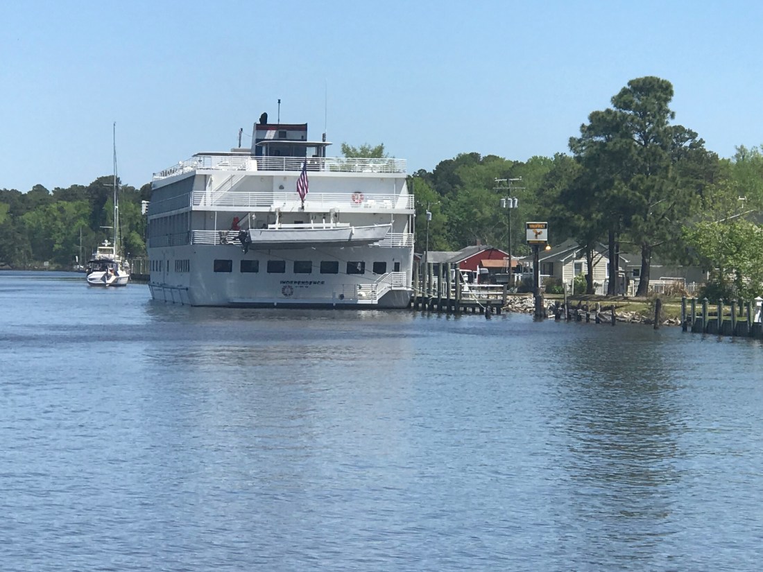
As we were pulling into Coinjock Marina, named for the NC town of the same name, we were aware that our port fuel tank was running on fumes. NOTE: we had some reserve fuel in the starboard diesel tank.

We had made two long runs up the coast and at almost 9 kts and burned lots of fuel. Coinjock about 20 cents more per gallon of diesel than the marina we were heading to next. While not the cheapest place to take on over 300 gallons of diesel it was convenient. I mentioned to the dockhand that the next marina North was 20 cents cheaper a gallon and he responded, “Oh, our costs are higher because we sell more fuel than them”. I just smiled and thought, I’m pretty sure this friendly dockhand skipped school that day in business class 😉
When choosing a location for diesel be sure to chose a location that sells a lot of diesel. Common wisdom says: the more they sell, the less time the deisel sits in storage tanks acculmulating condensation water or other contaminations. If you have ever had your engine die offshore due to bad fuel you’ll agree that it’s better to spend a bit more for the likelihood of clean fuel.
The cruise ship which had passed us on the ICW was now docked in Coinjock to take on 5000 gallons of diesel.
I believe in large ship terminology, the captain and crew talk about the amount of diesel they have in terms of weight rather than gallons. Diesel is about 7 lbs / gallon while gasoline is about 6 lbs / gallon. When you take on 5000 gallons of diesel you need to be thinking about how much that excess fuel weighs and what it does to your ship’s draft. Draft = how deep your boat sinks into the water. Air draft = how tall is your boat is above the water for fitting under low bridges.
MV Simple Life took on about 311 gallons or 2,177 lbs of diesel while we were there. We also filled our water tanks (8.3 lbs / gallon) so that adds another 3,700 lbs to our boat. If you ever read the specs for a boat it will list it’s dry weight as well as it’s water draft. Always remember that when you load your boat up with your possessions, passengers, dogs, food, fuel, water, etc that it will sink your draft a few more inches into the water. When a boat is designed they guesstimate the weight & displacement of the boat from summing up the weight of every item in the CAD drawing. This we know thanks to the ancient Greek scholar Archimedes and his “Eureka” moment when he figured out that a body (boat) displaces it’s exact weight in water.
An engineer friend of mine who also loves physics, Andy, once asked me this fun question about a man in a canoe in a pool who drops a stone into the water and asks how high will the water rise?
Boats with sharp narrow hulls must sink lower in the water to float while boxy square hulls like that of a barge need only sink a small amount to displace their weight in water. The boxy square shape to the cruise ship allowed it to have ashallower draft than MV Simple life. So don’t follow the cruise ship up the ICW thinking… ”if there is enough water in the channel for them, we can easily follow them”.


You must be logged in to post a comment.