
Invest 98 Where you going?
Note:: I’m crudely writing this blog post with little to no internet but want to update readers with what happened here.
NOTE: This blog post will update more when I have time and internet so please check back later..
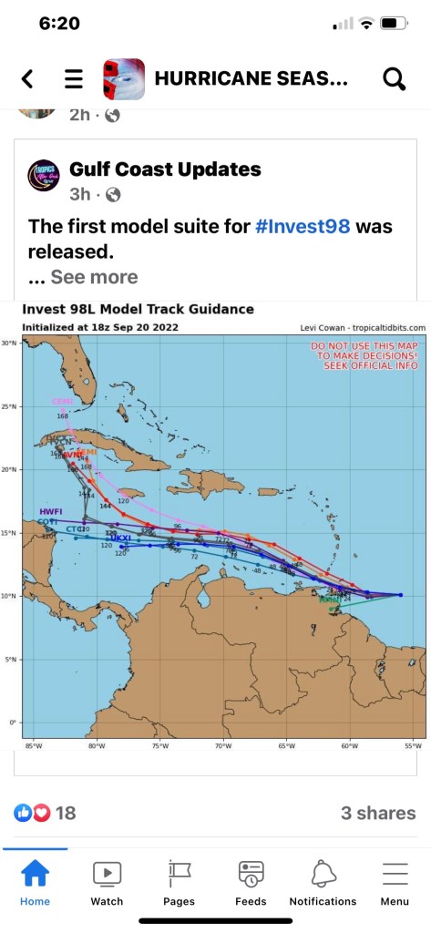
Before they are named storms they are atmospheric disturbances that need to be investigated.

Start of Hurricane Ian

When we’ll-known SWFL hurricane hunting weatherman, Jim Cantore, checked into a hotel down the street in Punta Gorda we all nervously joked that it was not a good omen.
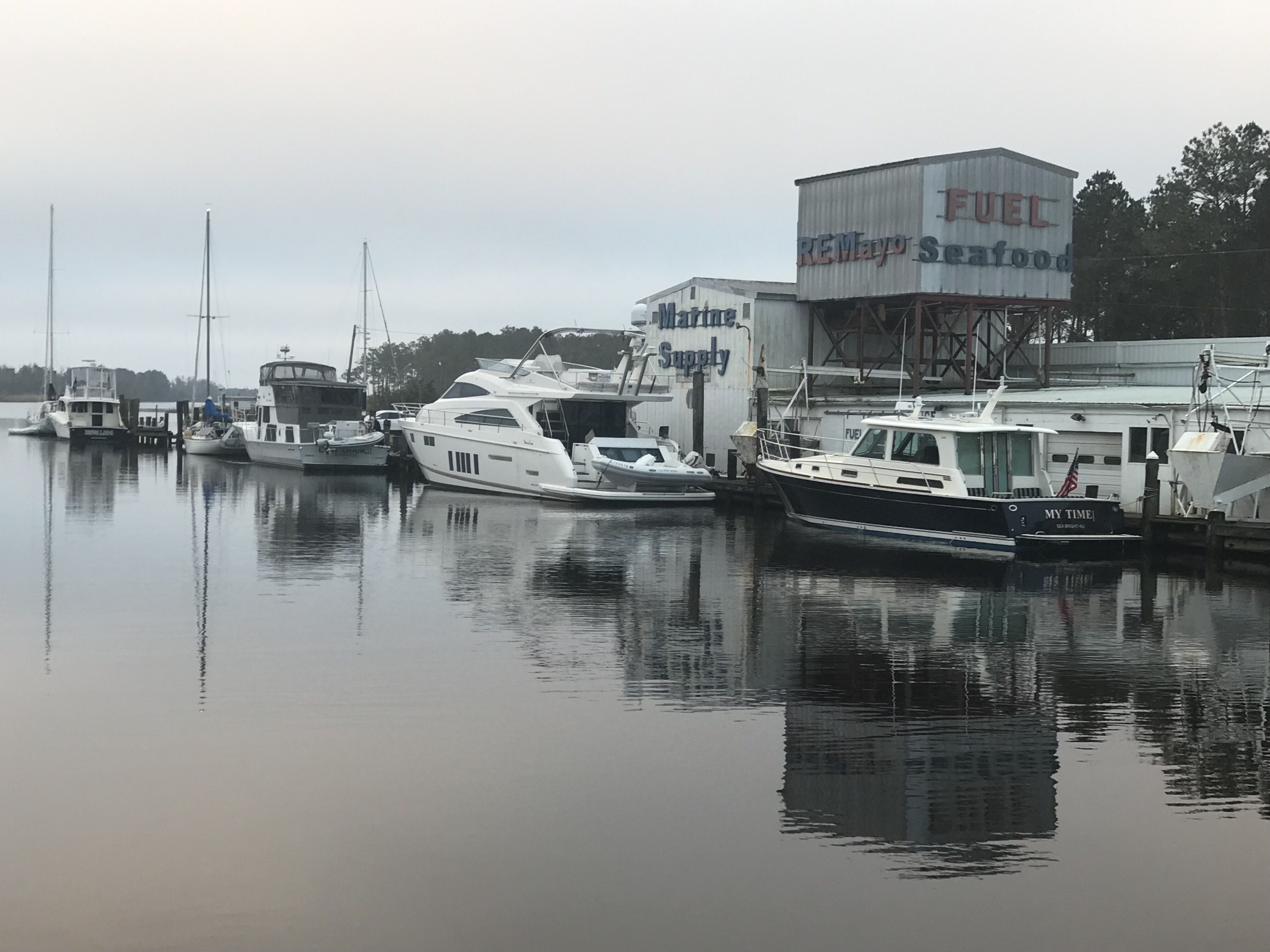
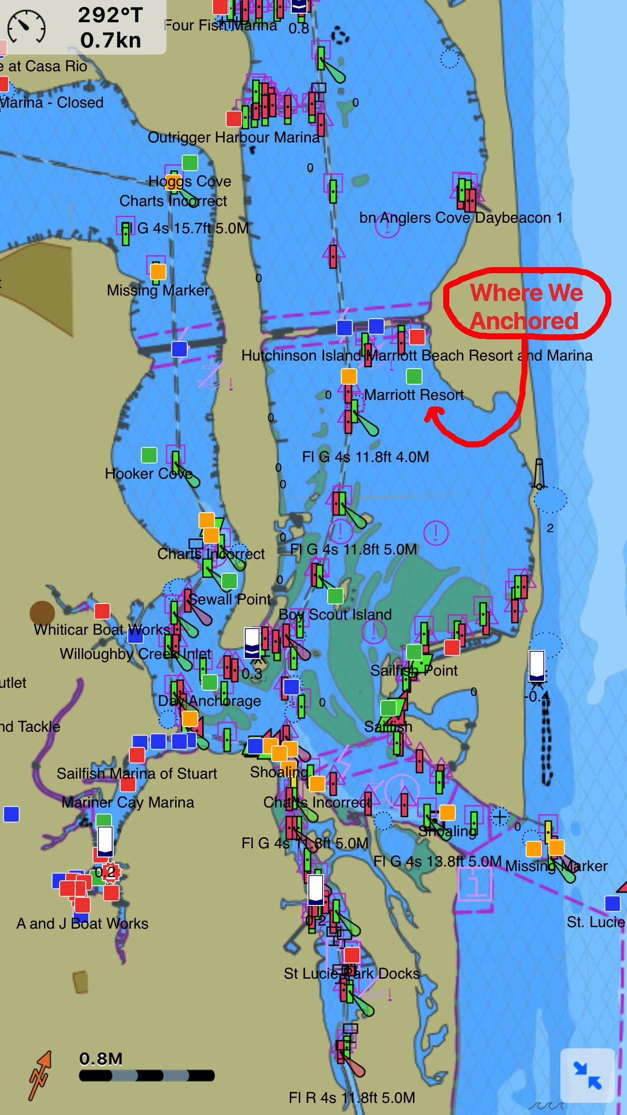
MV Simple Life is berthed just inside the entrance channel of BSM (Burnt Store Marina). The westerly wind’s friction with the ocean was creating a surface current and driving all the water out the marina entrance.
I rely on the Windfinder Pro app on my iPhone for predicted wind speed and direction forecasting.
https://apps.apple.com/us/app/windfinder-pro-wind-weather/id336901296
In the above screen capture video, you can see that blue dot is MV Simple Life in BSM. The wind was predicted to blow the marina’s water back out into Charlotte Harbor.


Getting your dock lines set to allow for such a drop and surge can be difficult and will come down to how low/high you think you will go, the line lengths you have available and cleat locations in relationship to pilings.
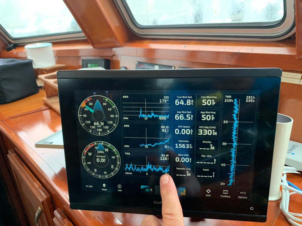
64 knots and gusting to 128 knots
The winds were now 64 knots and gusting to 128 knots.
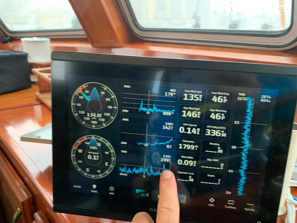
It’s now blowing 135 knots and I see my slip neighbor run outside from a neighboring condo to adjust his dinghy line to stop it from smashing into his sailboat. I quickly strap on a bicycle helmet, life jacket and a jacket to go help him. It’s extremely dangerous should the winds blow you off the dock alone. I climbed down off MV Simple Life and onto the docks but my neighbor friend is nowhere to be found. Then out of the corner of my eye I see him back on land waving his arms to get my attention. He was wisely making his way back to the safety of the condo so I climbed back aboard my boat as it was bouncing to and fro.
The Eye of Ian
In the above video, just before the eye centered on the marina, I jumped onto the docks to see the condition of my fellow boaters and the marina.
Above is another video shot while Ian’s eye was nearly over us. You can see my VHF antenna has snapped. I decided to quickly tape it down so it did not get ripped off.

While cell phone texts were not going through in real-time I could occasionally receive texts from the other two boaters around me who elected to stay aboard during the storm to hopefully save their own boats.
NWS alerts were periodically sounding off on my iPhone. I was now busy making adjustments and adding lines everywhere I could to prepare for act II of Ian.

Once the eye arrived the storm surge began rushing into the marina.
The boats were quickly lifted off the bottom and even the birds floating on the surface could not paddle fast enough to keep from being pushed backwards in the flow. See the end of the video below
The rush of water just kept coming and I knew I only had a moment before I needed to be back at the helm.
When the backside of the Ian arrived it was far worse for MV Simple Life. The wind direction did a 180 degree shift and was now blowing straight in off Charlotte Harbor. There is nothing in the way to protect MV Simple Life from the wind and waves. The stern of our boat is large and flat. My twin 8” diameter diesel exhausts we getting water forced backwards in towards the engines. Simple Life was pulling so hard on the two pilings behind my stern. I doubled up my lines prior to the the storm. The pilings began to rock back and forth as my boat and my neighbor’s pulled hard on them. If I pull these pilings over Simple Life will smash bow first into the dock and being the first boat in the marina I could only imagine a cascading failure as I keep hitting boats and docks in front of me with the wind pushing me from behind.
Engines in Reverse!
I quickly started the diesels to keep any water out of the engines. My yacht is 70K+ lbs. with large 5 blade props that were now running in reverse to take the strain off the pilings behind me. Occasionally, I would hear floating debris hit the propellers and flying debris hit the boat.
Boarded up Cockpit Doors
I had boarded up the twin cockpit doors which was protecting them from being blown out from the high winds and flying debris. The water was blowing through the door and running across the saloon floor.
I’m feeling good that the other windows are extremely thick and impact resistant.
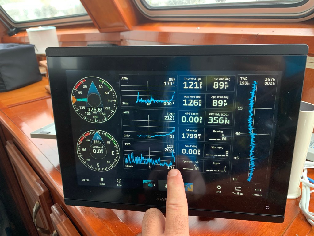
Watching Wind Meter
My wind meter is mounted on the top of the boats arch. It has been recording wind speeds above 100-150 MPH with a highest gust recorded of 202 MPH. Shortly after that the wind meter was ripped from the boat.
I had a couch that I could not get off the Flybridge and had attempted to tie down. I watched as it was levitated off the flydeck by the wind and dropped back down. This happened 3 or 4 times but suddenly it just lifted straight up and flew off about 30’ high and flying fast.
The Time to Get Off Has Past
Looking out the pilothouse windows at the docks I see they are 3-4 feet beneath the fast flowing storm surge. The water is black and you are not really sure where the docks beneath that murky surface. A few of the planks that make up the walking surface had been ripped off making the possibility of having your foot/leg fall through.
Getting off the boat now is no longer an option.
Hatch Rips Open
I was at the pilothouse helm when the flydeck hatch ripped open and the wind and water was blasting in on me. I ran quickly and managed to get ahold of it. I struggled to get it closed but each wind gust was lifting me off the floor. I in a situation where the boat is running in reverse, I’m not at the helm but trying to find some way to secure the hatch.
Lucky for me… arms length away was a fender with a short length of rope that I wrapped around the broken hatch arm. It held just long enough for me to run and get some cordage and add more lines to it. If it rips off I’m screwed. I quickly ran Dow into the engine room looking for a solution that would secure it for good when I spied half a dozen welding clamps that were exactly what I needed. I punched the wood away from the hatch to get to the solid aluminum and clamped & tied the hatch down. I felt relieved.
Concerns About Neighbors
From the onset, my concern have been for the other three boats who opted to stay aboard and ride out the storm. They have been terrific about asking me how I was holding up as well. We setup communication plan over text and VHF radio to be able to get messages to each other.
Now as I look out the window I see that one of those boats has snapped a piling off and is violently rocking. I see him crawl out on his foredeck presumably to get her under control. I look back and don’t see him. I’m texting him to see if he got back inside safely but no answer. (Spoiler he made it back inside)
The large beautiful yacht at the end of the dock has had a hole punched through the hull and the captain and first mate were now on shore.
The last couple have been aboard from the start and they are concerned the that boat on the lift behind them is dangerously close to coming off and smashing into them.
I realize while my concerns for my friends is made worse knowing that there is no way I could get to them if they need my help.
Concerns for my Neighbors in South Shore Condos
When I drove through the open and unmanned gates into BSM Community I saw no people. It looked abandoned. That said I know some homeowners stayed. When I look at the lovely South Shore Condos I can see directly into some of the units. I hope nobody was inside.
Starboard Engine Overheat Alarm is Sounding!
The helm is now sounding an overheat alarm so I shut one engine down and rush back into the engine room. My sea strainers are full of flotsam as the water is murky. I quickly work to clear both sea strainers and restart the engines. I feel relieved once again.
TO BE CONTINUED…


You must be logged in to post a comment.