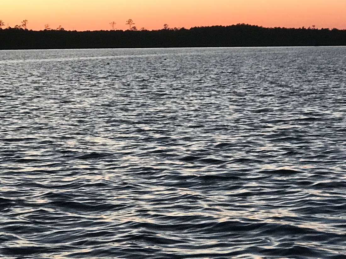
We awoke at sunrise and just before pulling anchor, I snapped a few photos of just how still this anchorage was in Adam’s Creek.
Sun Reflection off Still Waters
Active Captain Royal Thurman Anchorage
Today’s ICW route through Pamlico Sound would end just short of crossing Albemarle Sound. Our route looked something like this.
ICW Route Through Pamlico Sound and almost into Albemarle Sound
On our way out of Adam’s Creek, I hailed a loaded tug and barge to let them know we would deviate from the channel and not impede their passage. The strong current was at their back forcing them to keep their speed up. As a tug captain it’s better to be driving the barge rather than being driven by the current. It’s always better to push a barge into a current than be pushed by it. At least that is how I understand it.
Tug & Loaded Barge in Adam’s Creek Channel
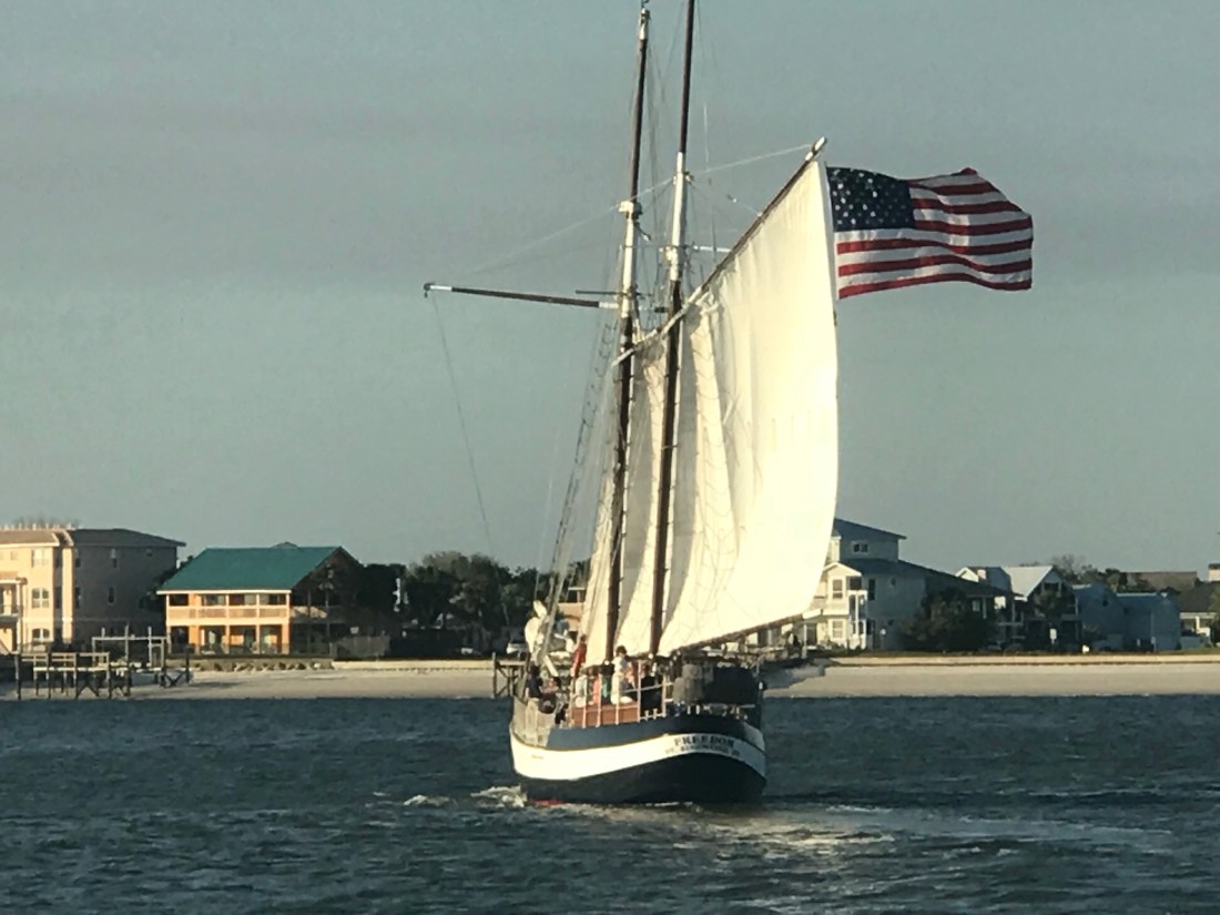
We no sooner exited Adam’s Creek into the Neuse River and passed this beautiful schooner with the captain at the helm and sails set.
Capt was still in the process of raising his staysail
Once it Pamlico Sound you realize it is a pretty large sound. Wikipedia defines a sound as, “…In geography, a sound is a large sea or ocean inlet larger than a bay, deeper than a bight, and wider than a fjord; or a narrow sea or ocean channel between two bodies of land (see also strait)…”. These geography terms can be confusing.
Pamlico Sound
As we motored on, a USCG boat hailed us over VHF channel 16 and let us know to stay to port as we passed. They had a line around and were pulling what remained of a green daymark piling using their boat. Our best guess is that a boat hit the piling in the night and snapped it off. We figured they were dislodging it so that it would not float away and become a hazard to navigation?
USCG with a line off their bow to a green daymark that was broken off.
We passed a several duck blinds confirming that North Carolina is duck hunting country.
Duck Blind – Do they really fall for this?
As we motored on we were reminded that we are getting closer to ICW mile marker 0 in Norfolk, VA.
Statute Mile 160
Statute Mile 125
Statute Mile 115
Statute Mile 100
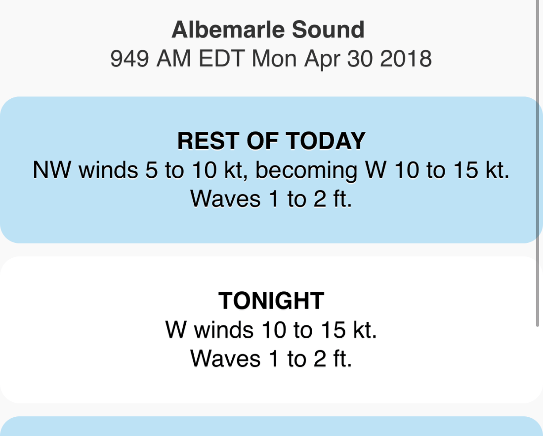
The predicted forecast for Albemarle Sound had the wind out of the West at only 10-15 kts.
Albemarle Sound forecast 10-15 out of the West
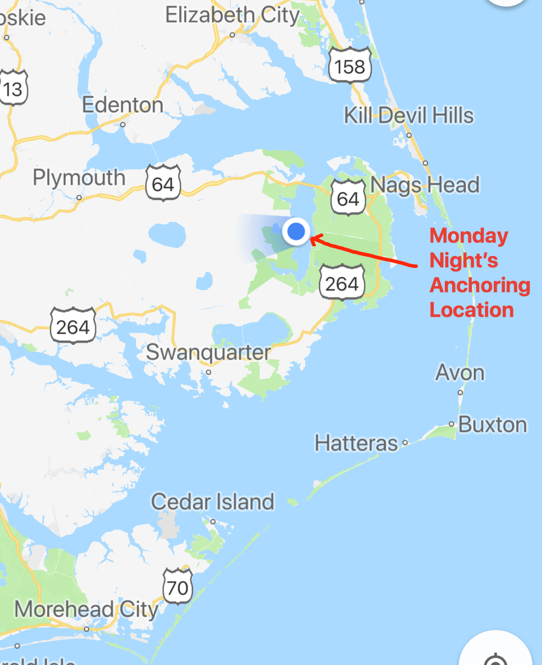
We chose an anchorage with a small fetch to the West but far enough off the shore that we could open the hatches and get a good breeze while we slept.
Alligator River Anchorage
As I was setting the anchor on the bow I looked up and snapped this photo of the setting sun.
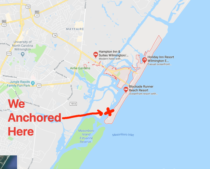
Because it was a 98.8% full moon, we pulled up the anchor and got underway before the sun had even risen.
Wrightsville Beach Anchor Location
As we skirted our way up the coast, we tried to minimize the length of fetch as the winds were blowing 20 kts from the NW (with gusts to 25 kts). Recall: a fetch is a distance of water that the wind has been given to blow over the top of. Wave heights build wave heights with distance.
25kt Gusts
Along the way we saw beach homes like these near Surf City
Surf City Beach Homes
Surf City Beach Homes
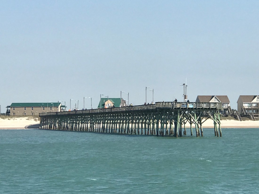
We saw a giant ocean-side pier near Top Sail Beach.
Top Sail Beach Pier
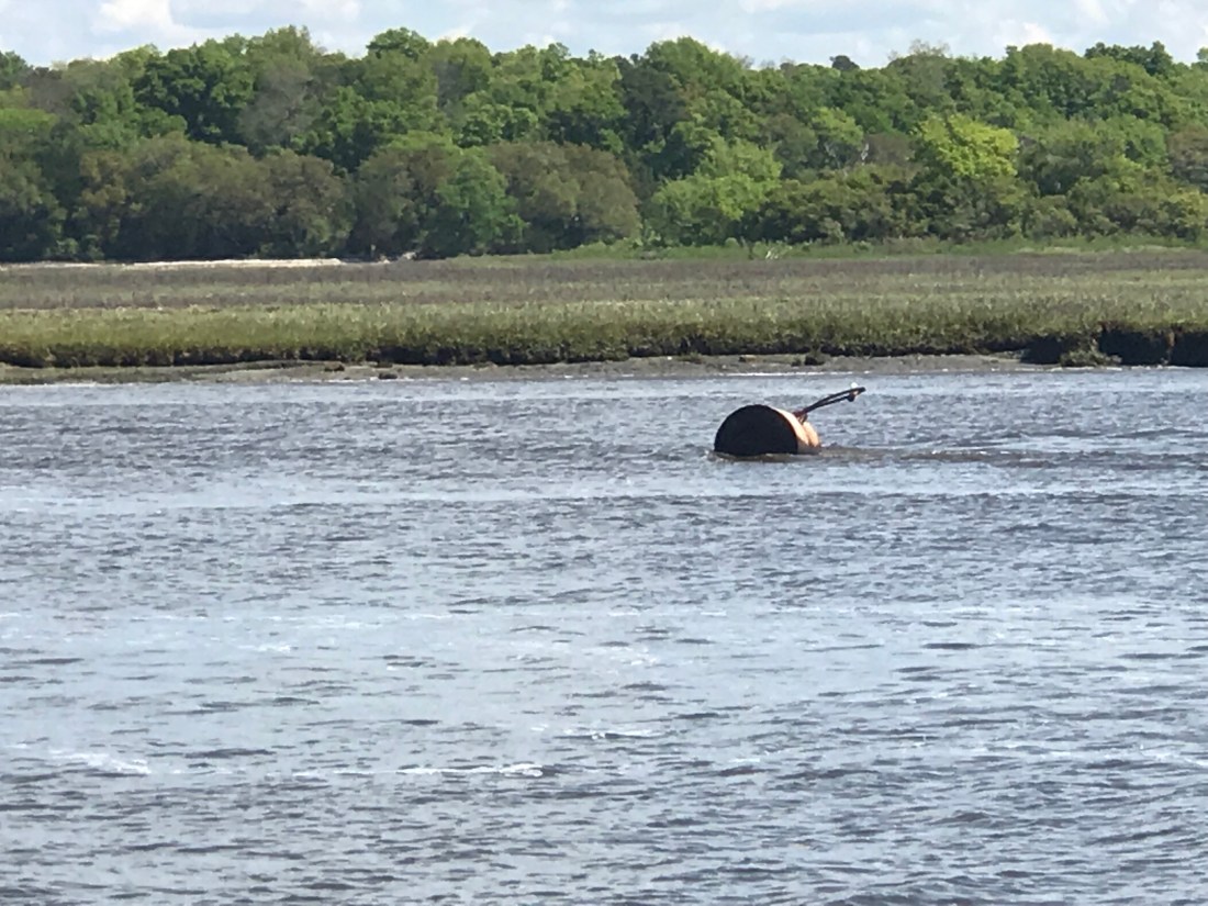
As we go, I’m always watching the depth sounder, ie sonar. It pings high frequency sound (like a dolphin) off the sea floor and displays the depth as a graphical chart over the last 60 seconds. It is very important to understand not just the instantaneous depth but also how the depths are trending over time. You need this info to ascertain quickly if you are running off a downhill slope or running aground. The steeper the incline, the faster in time the sea floor is rising up to meet you, metaphorically speaking. While watching the sonar, I repeatedly saw objects between the boat and ocean floor. I believe these depictions to be “bait balls” or schools of bait fish in a tight spherical grouping. Sometimes they are formed into these ball formations by preditors such as dolphins.
I’m no expert at reading the fish finder / depth sounder’s visually displayed ping returns, however, I also saw this fishing boat hauling a net.
Small Trawler Netting Bait Fish
The trawler’s size makes me think that they are hauling a small net sized for bait fish.
A moment later, we were passed by this Italian designed Azimut luxury motor yacht. She clearly has some horsepower in her diesels since… as big as she was, she was just skimming over Mother Ocean.
Azimut on plane
As we approached Beaufort, NC, we passed Brown’s Inlet. The ActiveCaptain description for this inlet simply says: “Browns Inlet is unmarked and used by local boats only;not recommended to strangers.”
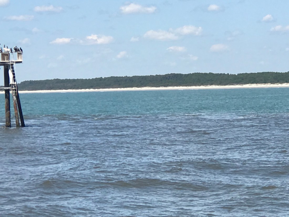
Soon we were off Fort Macon State Park Beach which is just before Beaufort inlet, NC.
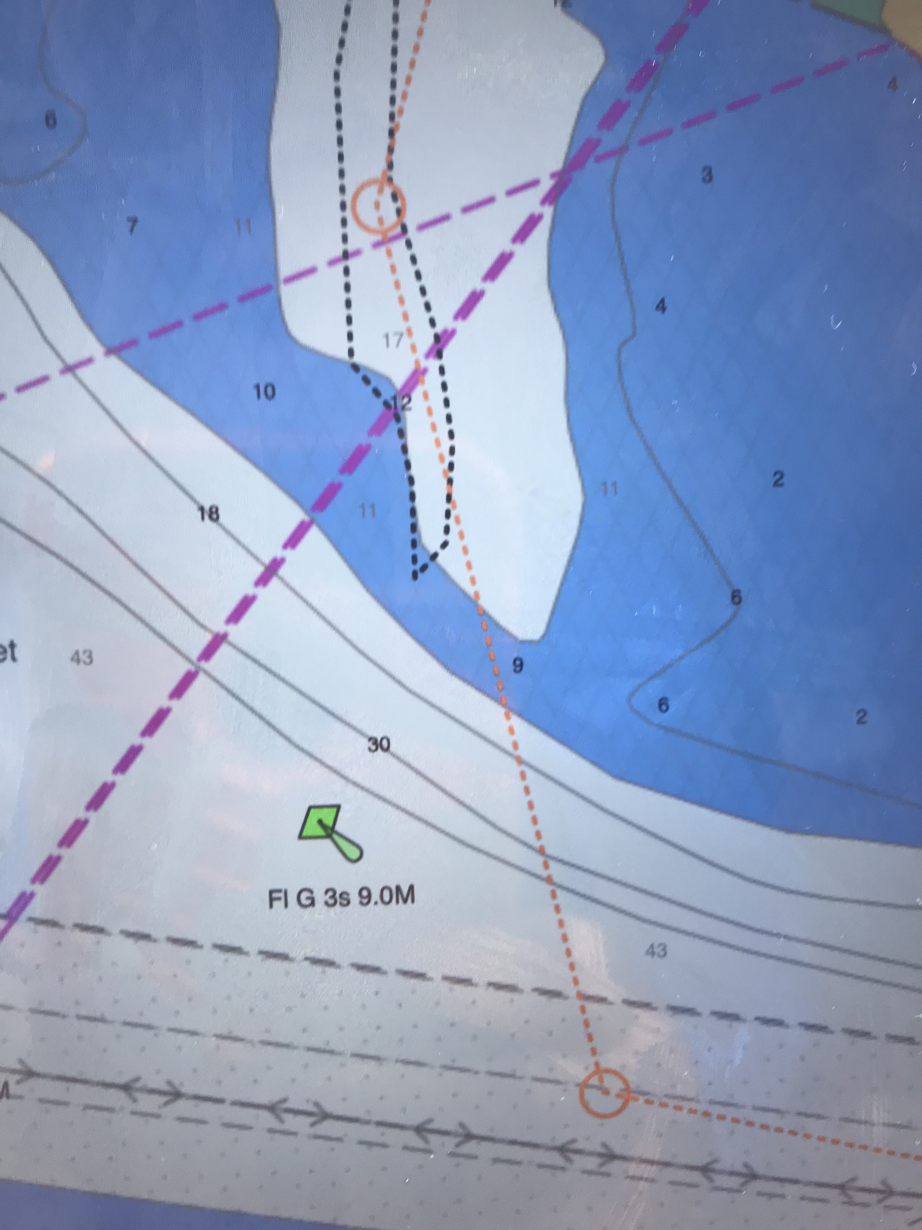
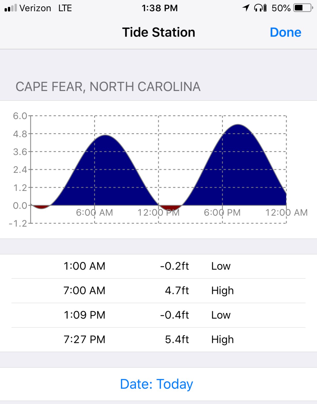
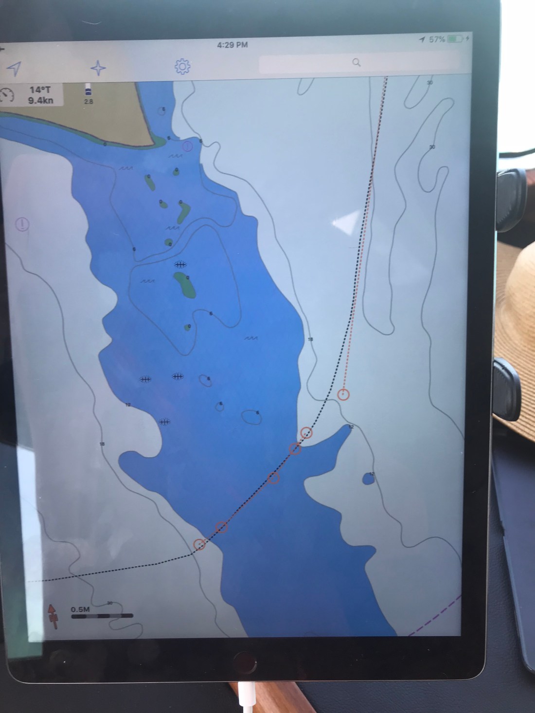
Running a dynamic inlet whose shoals change with each storm is not advisable as even the latest published charts with depth soundings will likely be incorrect. That said, we attempted to use the latest NOAA charts to sneak into Beaufort Inlet via a narrow channel close to shore. It was low tide so you don’t get any added water depth over the low water spot soudings. We entered the narrow natural channel displayed on our chartplotter. I checked the accuracy of the spot soundings (depth numbers) and the actual depths (reported by the sonar) were 3’ shallower than what my recently updated chart displayed. That was not comforting, but I still proceeded slowly at only 1.7 kts.
1.6 kts is slow forward
We will run aground at about 5’ and I was already in only 6.7’. To make matters worse, there was an ocean swell that was lifting and dropping the boat above and below the static ocean surface. I was confident that however “skinny”, “thin” or simply “shallow” the depths got that we would make it. After all my charts showed a low of about 10’ and we only needed 5’.
Well, we made it about 10’ from crossing into the deep channel when we bumped the bottom. You have to tell yourself: “resist the temptation to simply push the throttle forward and plow the next 10’ to the deep channel”. You just can’t know how shallow those next 10’ are. You could be pushing your boat up onto a shoal so shallow that the diesel engine / propeller combo won’t have the bite on the water needed to either push or pull you off the shoal. I opted to put her in reverse and spin her back the other way. We knew if we didn’t hit on the way in, we would not hit leaving.
5.8 is Shallow10′ more and we could have made it into the deep channel
Note: The top picture showing the chart with 5.8’ depths displayed is not as recent as the chart depicted in the picture below it. We were literally 1/4 of a boat length from making it into the deep channel. You can see our track as we backed out. FYI: track = a black, dotted line or bread crumb path of where your boat has been. The dashed orange line with circular junction points is our plotted course. We backed out and came in the inlet via the mid-channel / safe water buoy. This buoy marks the center of the entrance channel. Line up with this vertical red-white striped buoy and you are heading directly in the inlet.
Confidence is a good thing as a captain but … so is restraint 😉
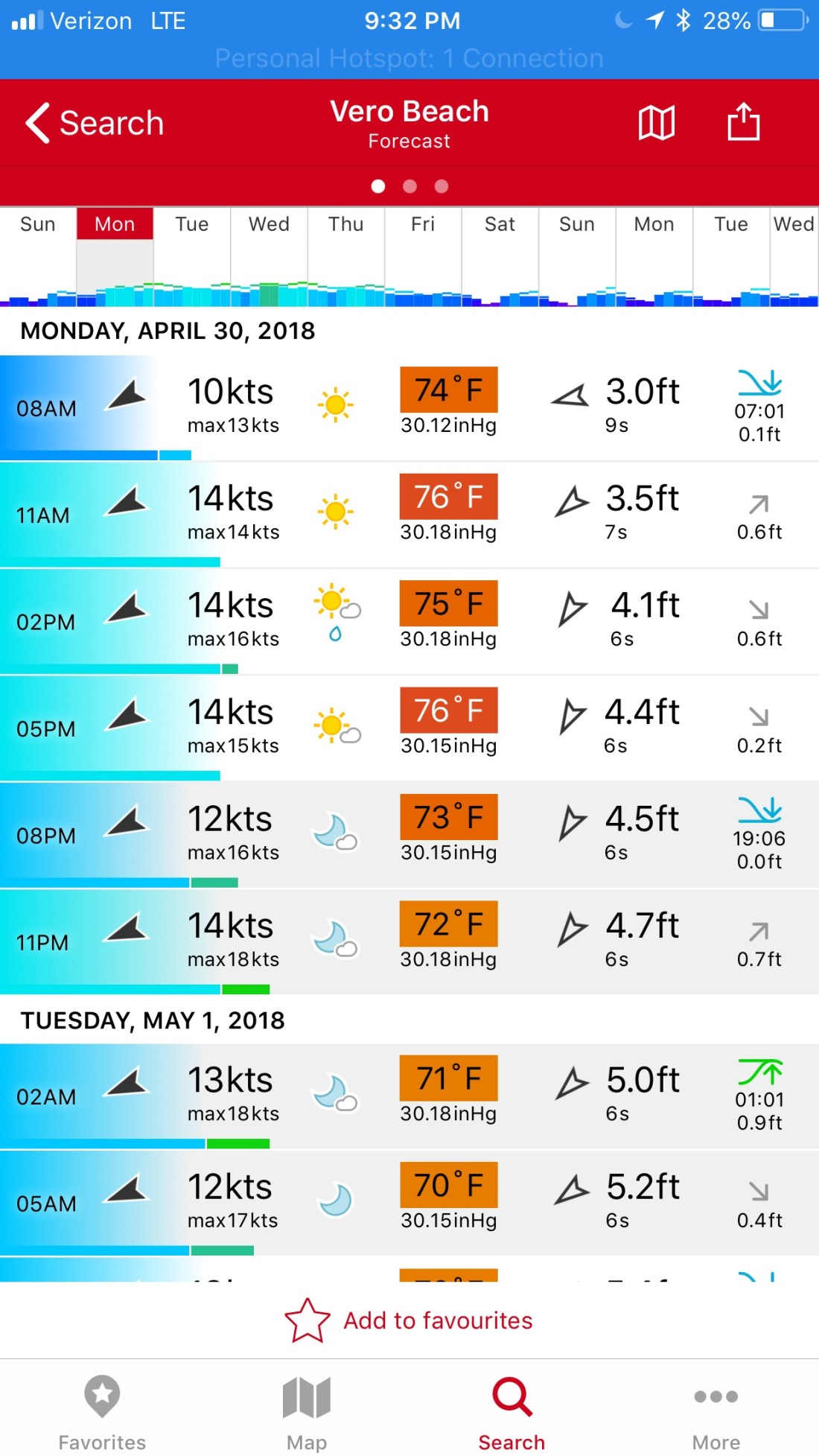
I was emailing with a fellow boater who was getting ready to come North from Vero Beach. They have owned their blue water trawler and traveled up and down the coast. However, I still added the below statements to my reply. I did so because, I myself, am often curious where other sailors draw the line at the decision to “go offshore or not”?
3. Six seconds is a rather short period. I’m picturing steep waves. Your boat is stabilized, ours is not. I would not want 6 second period, 5′ possibly 7’ waves on my beam.
When you study the densely displayed data given by this app,you see that the waves during the daylight hours will be… at worst 4.5’, out of the NE with a 6 second period. The tide will go low about an hour before the sun sets (read that as… “about when you are entering the shoaling inlet from the sea”).
Then you say “4.5’ waves are not that bad”. However, that wave height forecast is based on a statistical wave distribution.
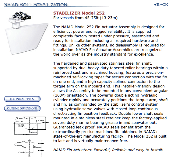
The average of the biggest 1/3 of the waves you’ll see are much larger, possibly to the height of 6.5’. That is uncomfortable to most crew in an un-stabilized trawler. Note: Blue water, top-heavy, flybridge trawlers often use active fins beneath the waterline to oppose the roll of the vessel to port or starboard. This can dramatically improve the conditions underway in a sea. Naiad is one such company who manufactures marine stabilizers.
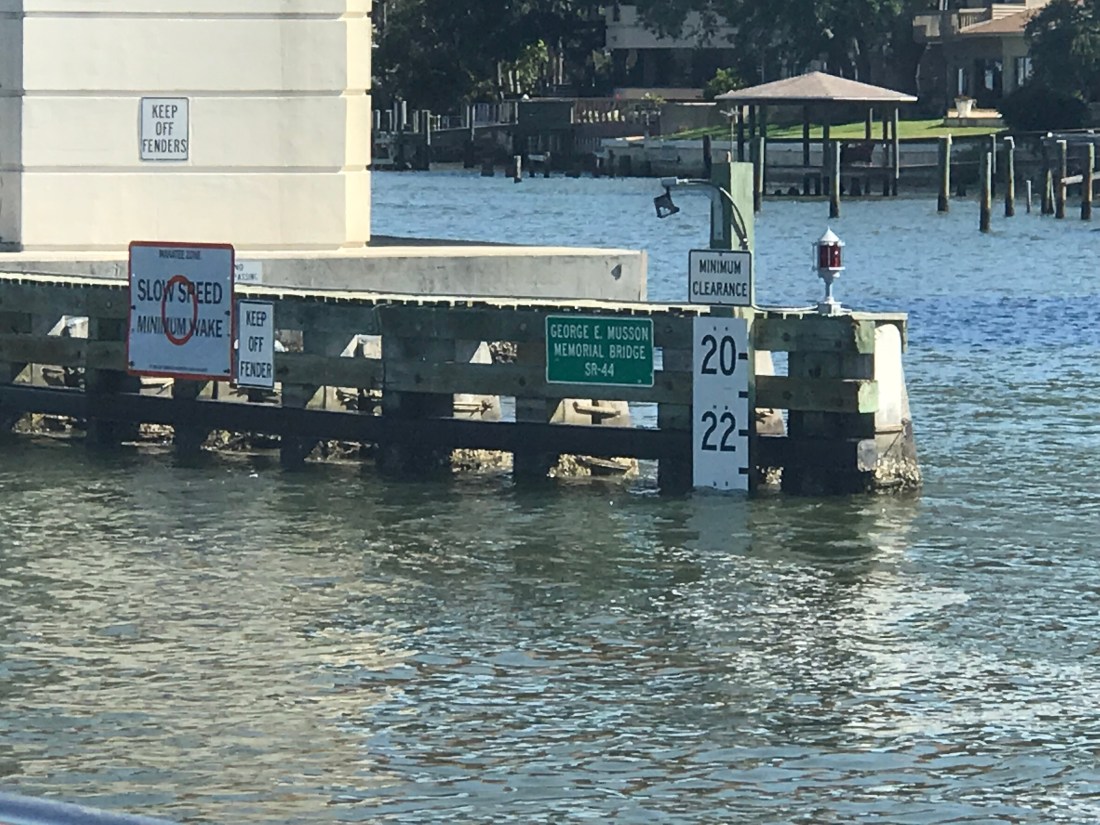
After making our way in the inlet we passed ICW statute mile marker 200. Note: Mile 0 starts in Norfolk, VA and the ICW milage progress to statute mile 1243 in Key West.
ICW Mile Marker 200
We made it into Adam’s Creek before having to anchor up for the night. Adam’s creek offered us the last anchoring spotbefore we enter Pamlico Sound and must travel the next 25 or so nautical miles to the Goose Creek anchorages.
Our current anchorage does not offer wind or wave protection but the holding is good. The NE winds are forecast to be light, at only 10kts.
I found it interesting that we had a full moon rise off the stern and a simultaneous sunset off the bow.
We got underway early, leaving the Waccamah River behind us. Alongside the ICW we found houses like this one. This home just stood out against the others. Why? Crazy downhill fence, twisty walkway? Sawgrass? 2nd level stairway? The palm trees? Or does it all work together?
Breathtaking, like that Seinfeld episode with the ugly baby
Then I passed this 27′ trailerable Nimble Kodiak motorsailer. Interesting little boat. Here is a link to a random 2002 Nimble Kodiak for sale on Yachtworld.com
27′ Nimble Kodiak trailerable motorsailer
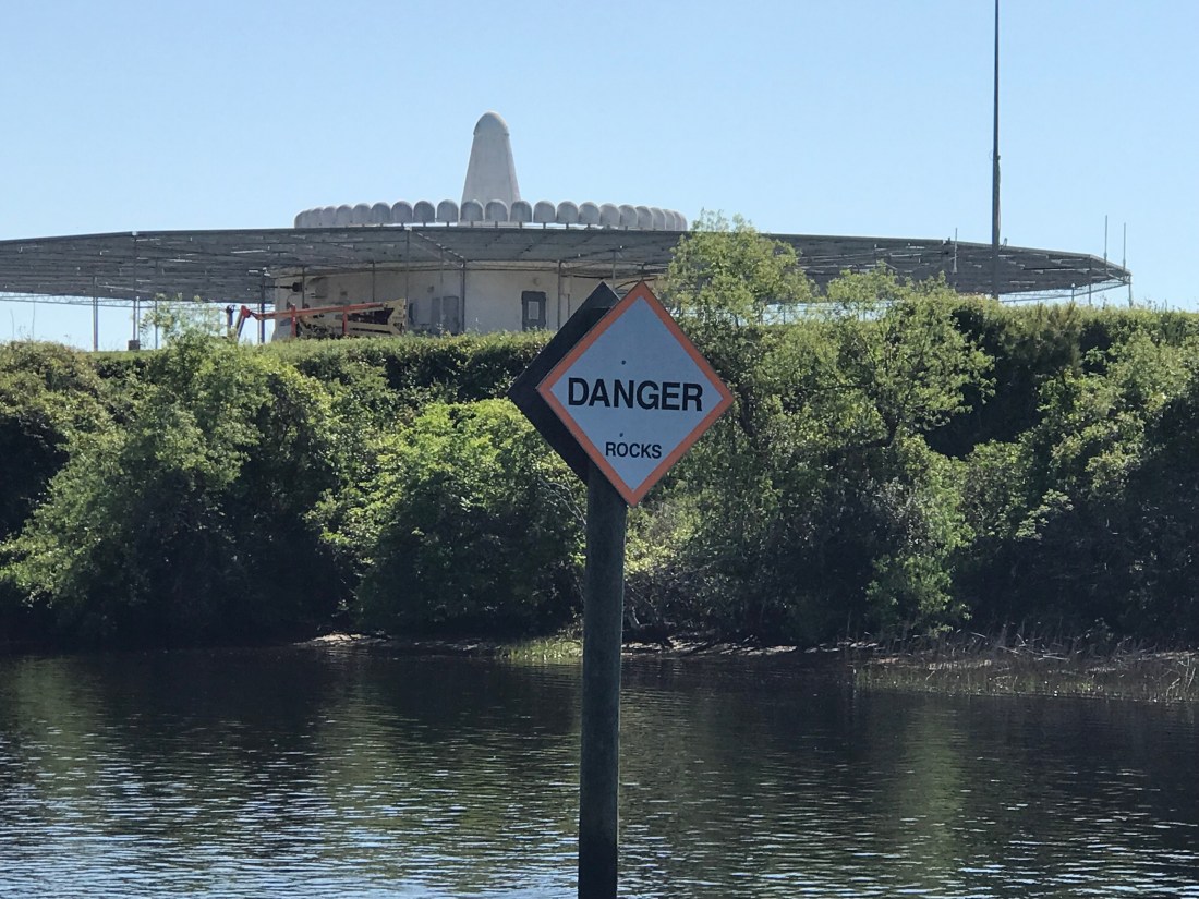
We passed the “Sombrero thing” that I could not quite figure out what this place was on our way down the ICW. Now we are heading back and I still have not looked it up.
Sombrero thing and Yes there are propeller eating rocks on the ICW
We passed the Myrtlewood golf course right on the ICW. I’m thinking how many boats get hit with golf balls?
We also passed a home or restaurant that had all these HUGE ocean buoys all around their lot. I love red buoys and green cans but I’m not sure I’d want them as yard ornaments?
Big Red Buoy
Green Bell
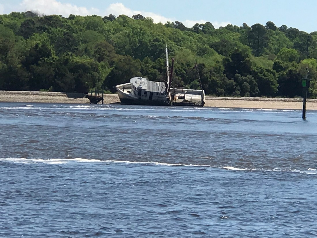
Then we came to “Little River Inlet”. You can’t miss it because it has this commercial fishing boat marking the entrance off the ICW.
I guess even the pros can have an oops moment?
Kelly & I recall this inlet as one that we ducked into on our old sailboat, Skull & Swords. We were getting beaten up in a storm off Cape Fear and the moment we tucked into Little River Inlet it provided us with a place to anchor for the night.
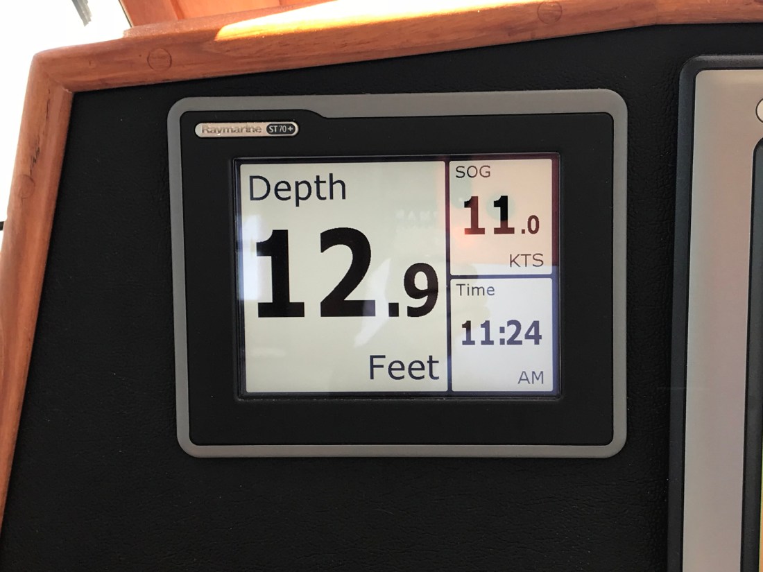
The ebbing current was running strong as we never hit 11 kts.
11 kts SOG – Speed Over Ground (GPS calculated)
As you twist your way out to sea be careful of the floating steel drums that are just outside the channel.
Would not want to hit that at night
Little River Inlet twists a sinuous path to the ocean.
Snaking it’s way to the ocean
The strong outflow created a distinct boundry between the brown, full of sediment water rushing out and the green water off the coast of NC.
Sediment laden waters flowing into the green sea
Friends of ours, Jimmy and Wende had just taken their fishing boat out of Lockwood Folly Inlet and were chatting with us on the VHF. I had to raise my 45 degree lowered antennas to the upright position to get better reception. On the ICW you must lower your antennas to fit under low bridges. The reduced reception does not matter as you are really just communicating with a passing boat or a marina that you are next to. They were quick to end the call reminding me to put my antennas back up, which I just did after writing that 😉
The inlet they came out of might scare anyone who looks at it on the charts. When you see a bunch of shipwrecks dotting the inlet it might be telling you something about the inlet.
That’s a lot of boat bones
We had planned to go offshore at Little River Inlet and run the 25 or so NM to Cape Fear. However once we were outside we were enjoying making over 9 kts.
Making good time
We decided to see if we could find a way through Frying Pan Shoals rather than around them. I spent some time plotting a course that in the end had us seeing 8.7′ at the lowest. Normally we would simply plot a course around Frying Pan Shoals but the added distance could mean a nighttime arrival. A check of the tides showed that we were not going to get much of a lift from the tide.
Barely 2 hours after a negative low. won’t add much water to the chart soundings
The swell presented a bit of a challenge as well. Ocean swell can push a boat closer to the sea bottom when you slide into the trough of a swell. The swell also can cause “breakers” (think breaking wave tops) where the shoals are shallow. Today however, as we cautiously motored over the shoals our path was uneventful. If you want to cross the shoal there is a path that lies about 3 nautical miles off the point of Bald Head Island. Just take your draft and everything else into consideration before you attempt.
Our Actual Path over Frying Pan Shoals – 3 miles out
Once we rounded Cape Fear we were making good progress toward Masonboro Inlet and Wrightsville Beach. You can see on our iPad navigation app the boat icon that is us, a black dotted track line that is where we were as well as the magenta 3 mile offshore dashed line.
Us rounding Cape Fear
Once inside the inlet we quickly anchored up and watched the sun go down
Setting sun
Dipping below the horizon
Gone
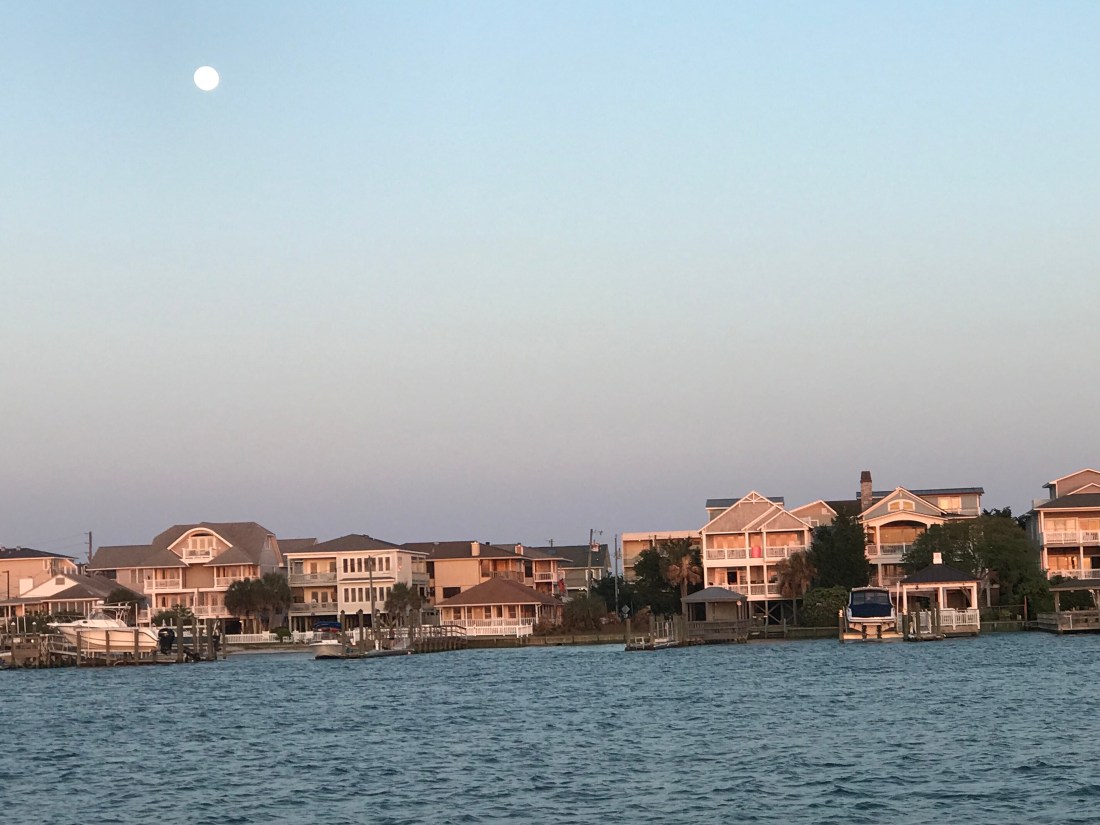
While the sun was setting the full moon was already up.
OK, it’s not technically a full moon but 98.8% is close enough. Tomorrow we’ll have a full moon.
As we sit here @8:30PM in the Waccamaw River, I can’t help but think how serene it is. Thinking back to where we began this morning, it was just 6:45AM. It’s a reminder that when your boat moves at 7 kts & you need to cover lots of ground, you’ll be putting in long days at the helm. We used to sail for 12 hours with no bimini top in the beating sun. Now, a bit older & wiser, I hide from the sun in the pilot house. That’s not Kelly, she’s a sun worshiper. While underway during the mid-day heat, we closed the portholes and hatches to the bugs and ran the genset & AC. I know, SHAMEFUL, but Oh the coolness was a welcome reprieve against the heat and insects as we made our way down a very shallow ICW in SC.
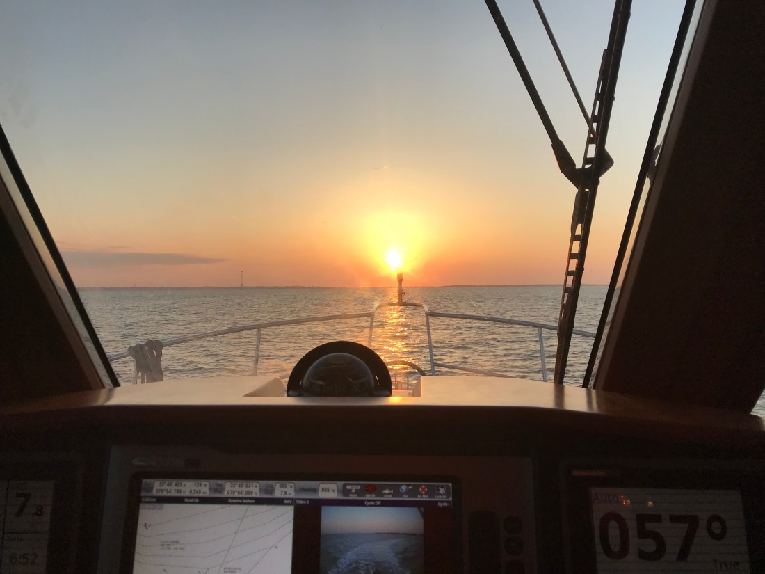
Here is the AM sunrise in Charleston, SC.
Charleston, SC Anchorage S of Fort Sumter
As we made our way through the harbor, that very same sun became my biggest obstacle as we headed East. FYI: Don’t pick a course directly into the sun
Piloting into the sun is like starring at a lightbulb
We passed this “Habah Monstah”
Habah Monstah
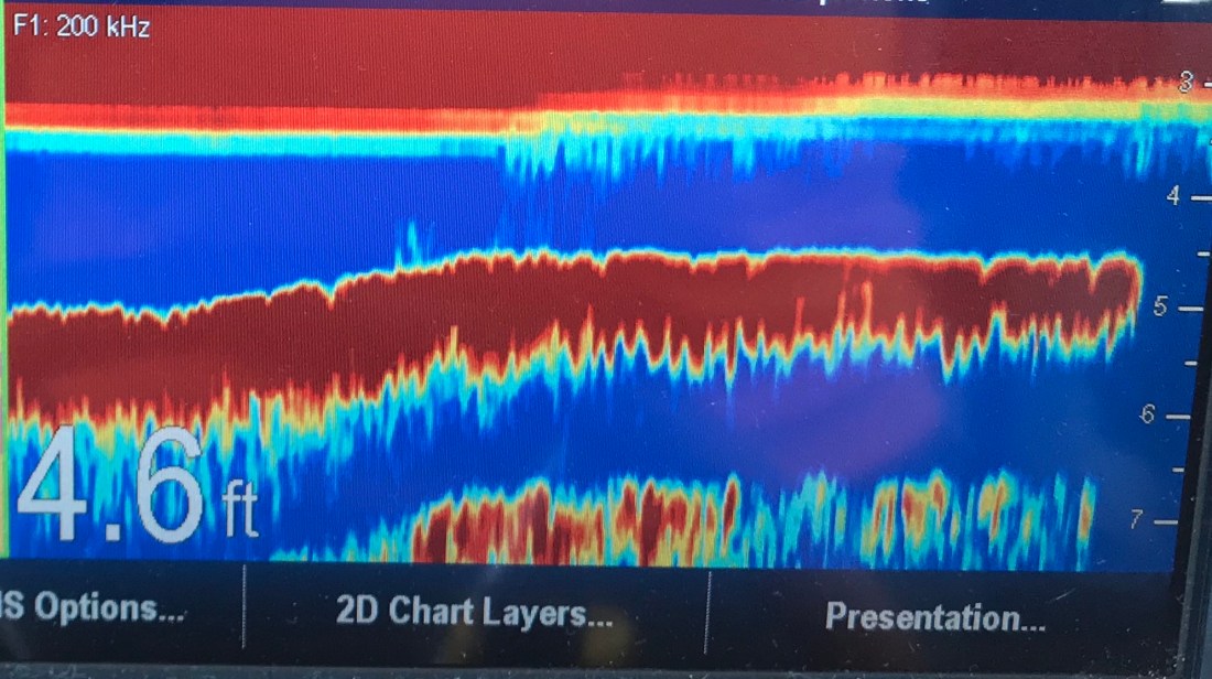
But riding up the ICW involves paying attention to the water depth which soon dropped from and average of 12′ to under 6′. When you see the water get “thin” you slow down to prevent grounding in a way that you may not be able to power off the shoal.
Some areas as deep as a puddle
I’d love to say as a captain that I never run aground but if you push hard, you’ll eventually run aground. The trick is to do it slowly. When the water is 6′ or less we proceed at low speed. We often zig zag back and forth as we move forward seeking a path to deeper water. Running aground is just a fact of life in the ICW.
Sonar graph showing water depth over time
Yes at 4’6″ we are aground. As a captain you learn to watch the depths and if you do run aground, do so gently. You’ll need to use that 26″ prop and 330HP to pull the bow of your 36K lb boat off the shoal that you just plowed onto. Go too fast and you’ll ground more than just the bow. It’s also comforting to have a full keel that keeps your prop above the mud and sand.
Docks, high & dry
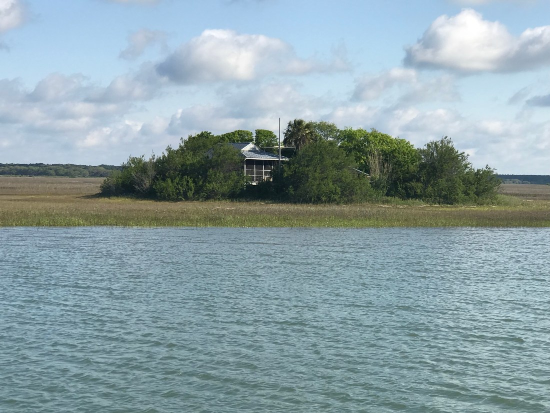
After backing off and finding deeper water, we passed this house that just made me think .. how cool. It’s completely enveloped in trees and shrubbery. Maybe it’s a secret hideout?
This house just makes me smile.
Even more surreal were the clouds. It’s easy to find beauty in these!
Clouds. Are you stoned enough?
We set a date of 5/18 that we need to be in RI. Every Captain knows NEVER to do that. However, that is our fate. It means that we stress about getting the boat to a particular location on a particular day. Many times that can end in disaster because you are pushing too hard and not respecting mother ocean and the weather. We have already pushed past many other boats who chose to stay in port and I think they have the right idea. That said, we are hoping Mother Ocean will be kind to us when we need to run outside from Norfolk, VA to NYC. The anchorages are far apart and not the most protected on that leg of the journey.
But tonight, tonight it’s like a mirror on the Waccamah River. The dogs are in my lap and they are snoring away.
Tree lined Waccamah river
floating flora
mirror flat
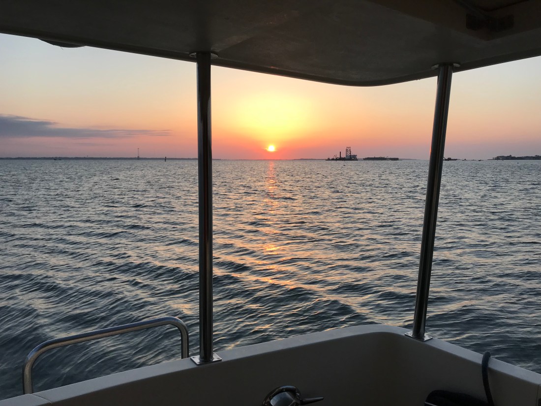
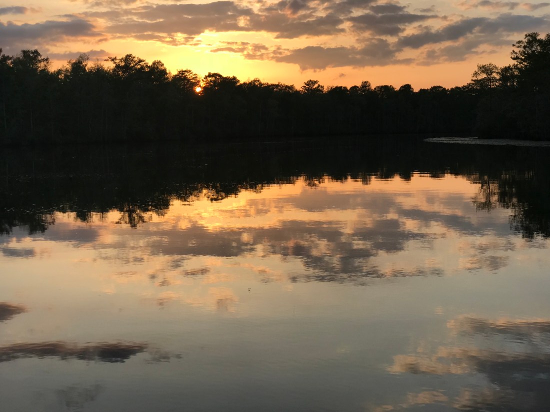
While the river is beautiful the sunset is amazing..
Waccamah River sunset
As we get ready to retire for the night and glance up at the night sky, the stars seem to be close enough to touch. Time to contemplate life and existentialism. . We Love feeling small in the cosmos…
Our last night in Beaufort we got to meet the new owner of a 2010 North Pacific 43 called MV Quiescent and his crew mate (my fellow DB admins will recognize the term “quiescent” as we all have to place the DB in quiescent mode to perform a DB backup). Quiescent = in a state or period of inactivity, dormant.
Stuff Tech Nerds Say
Kelly & I quickly set up chairs in our cockpit for our new NP friends and we enjoyed a beer and listened to their tale. They were nice folks who had just purchased the boat in Stewart, FL but had some difficulty during their trip North. After catching their lines when they arrived, I learned that they were having some electrical issues and had pulled into Downtown Marina to meet a boat serviceman to diagnose and repair the issue. After only a few minutes aboard the service guy said … “We have a bigger issue, the boat is sinking!”. Apparently, the PSS seal’s cooling hose had been pushed up against the prop shaft and melted. This caused water to begin filling the engine compartment. To add insult to injury the bilge pump switch was not operational. The water in the engine room had crested the engine room floor boards. A quick manual running of the bilge pump brought things under control as well as plugging the broken hose and adjusting the PSS coupling so it was tight enough that the flow of water coming in was down to a small stream. I’m happy they were able to get this under control as nobody wants to lose the boat they just bought on it’s trip home.
In the morning TowBoatUS strapped them into a hip tow and wicked them away to a boat yard to be hauled and repaired. I’m sure they will be back on the water within 24 hours. I hope we run into them again but under better circumstances.
MV Quiescent being towed in for some quick repairs
Once they were gone we borrowed the marina’s courtesy car. A classic Ford wagon but it’s FREE (just put gas in it).
It’s Free to a Good Capt
I used the courtesy car to make a run over the Lady’s Island swing bridge to Bill’s Liquors. While pulling into the parking lot a biker dude laughed and said he’s sure that the courtesy car knows how to drive itself to Bill Liquors. It was not the first time the car had pulled up out front.
Once back at the marina, we pumped out, took on 260 gallons of diesel, filled the water tanks and cast off our lines. Almost as soon as we headed North we were treated to about a dozen or so military jets screeching directly above our heads.
As the afternoon light was fading we were pulling into Charleston, SC. Charleston City Marina was full of large yachts as was the anchorage.
Charleston City Marina
We had pre-selected several anchorages that just did not work. Most were very crowded and the reviews of a few others mentioned boaters fouling their anchors on underwater hazards. From the look of a sailboat mast sticking up out of the water I’d guess there was more than one boat sitting on the bottom of the anchorage.
As the last bit of light left the harbor we decided to simply drop the hook along the harbor’s shore and get some sleep.
Tomorrow we hope to make it to Georgetown, SC. A trip of not quite 60 miles North.
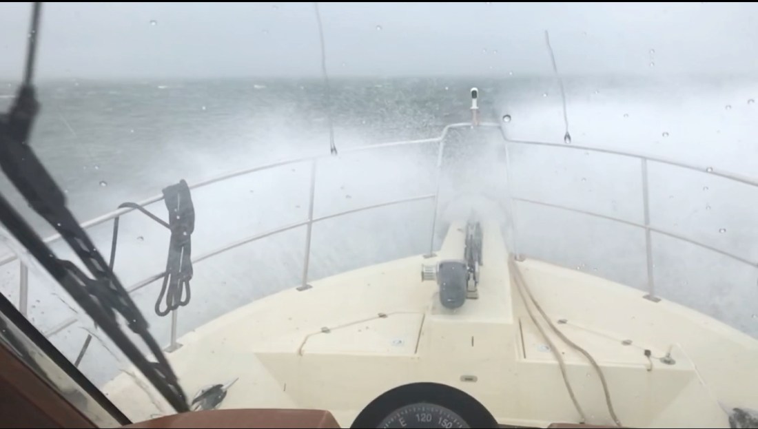
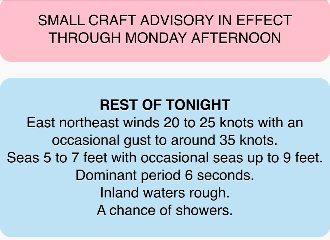
We had reservations to be at Downtown Marina in Beaufort, SC and the weather was not looking good. With 25 knot winds and gusts to 35 knots.
35 knots = 40 MPG Gusts
As we rounded Hilton Head Island the only thing my radar saw was rain.
That Magenta on the screen is rain reflecting my radar
Our route would look something like this:
Our Route from New River to Beaufort, SC
There were only a few locations where I knew we would have to face the wind if just for a short bit. When we rounded Hilton Head and came out of Skull Creek to cross Port Royal Sound inlet was one of them.
Skull Creek along HH Island into Port Royal Sound Inlet and then up the Beaufort River
The weather worsened just as we were crossing Port Royal Sound Inlet. High winds shutdown the Lady Island swing bridge but luckily we have a reservation @ Downtown Marina in Beaufort, SC just feet from the shutdown bridge.
Waves maybe 3-5’ with the occasional 6-7’. The challenge was that I was hitting each new wave in under 2 seconds and having to work the throttle to slow down from say 6 kts to 4 kts for the larger waves. Being an unstabilized trawler we headed into the waves (rather take them on the beam) till we got a little shelter from the Northern side of the Inlet. Then we had to turn and run at 10 kts with the waves on our stern.
As we approached Downtown Marina the Lady Island Swing bridge was shutdown due to high winds. Docking in high winds and strong currents makes for an interesting learning experience but the dockhands and fellow boaters came out in the driving rain to help catch lines. We had to put out extra fenders to keep the waves from smashing us into dock but it was time for a beer and to sit back and watch the storm.
The next day we observed the rushing sounds of water around the boat and took a short video of the current alongside the dock.
Beaufort, SC is a wonderful stop and we always enjoy the local restaurants like Plum and the gastro pub, Old Bull Tavern
We’ll use the time here to re-provision the boat and get ready for another week of anchoring out as we attempt to push North into North Carolina.
As we weighed anchor in Robinson’s Creek you could feel the power of the wind. The airport wind speed last showed a 30 MPH gust.
25 MPH Winds with 30 MPH Gusts as we passed NE Florida Regional Airport
Even with the strong winds a pair of US Custom agent boats zoomed by, unaffected.
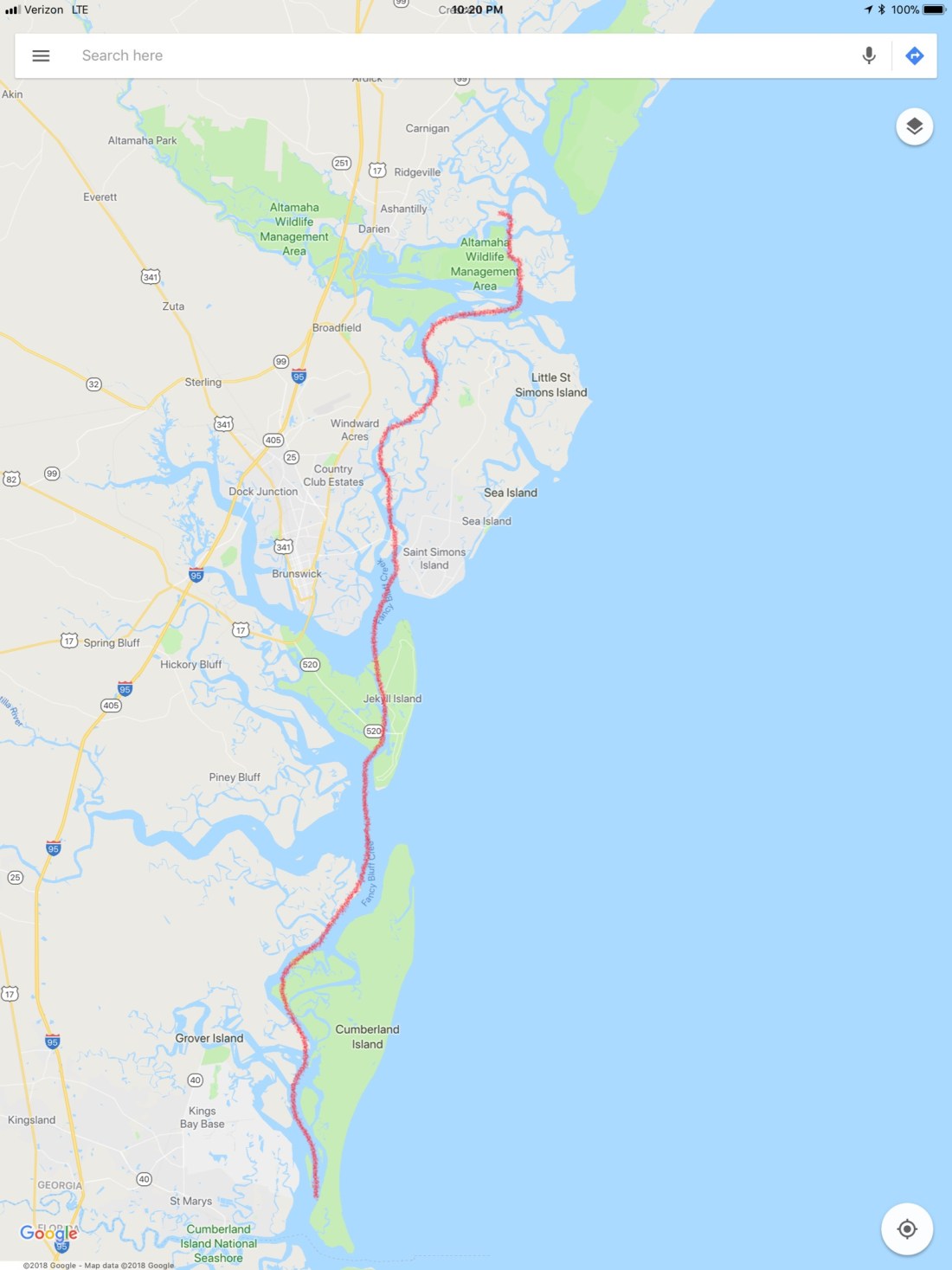
Our route would look something like this:
Our Route from an anchorage in St Augustine to Cumberland Island Anchorage
We would avoid many shoals:
Shoal near South Sapelo River.
We would cross over the St. John River in Jacksonville, FL and see sights such as this Navy ship in dry dock. What a narrow beam and sharp bow these attack vessels have.
Navy Ship in Dry Dock
I had always wondered what a trawler would look like with a wind generator mounted on the fly deck and I just have to say I can’t imagine ever doing this..
A trawler with 3 Wind Generators on the Flydeck
The free overnight dock in Jacksonville had a spot open but we were determined to use what we had left of the light and cover more ground. Our plan was to cross over the Savannah River and into GA.
Once in the Savannah River we saw that many of the river banks had been built up possibly for storm surge.
Lone Tree standing proud on the banks of the Savannah River
As you approach Cumberland Island there is a heavy Navy presence in the area. We passed these two big Navy ships in port.
Navy Ships near Cumberland Island
We read the writeup on the Cumberland Island Anchorage.
AC Cumberland Sound Anchorage writeup
We chose this anchorage because it offered a lee in the face of strong winds.
Our Anchor spot in Cumberland Sound
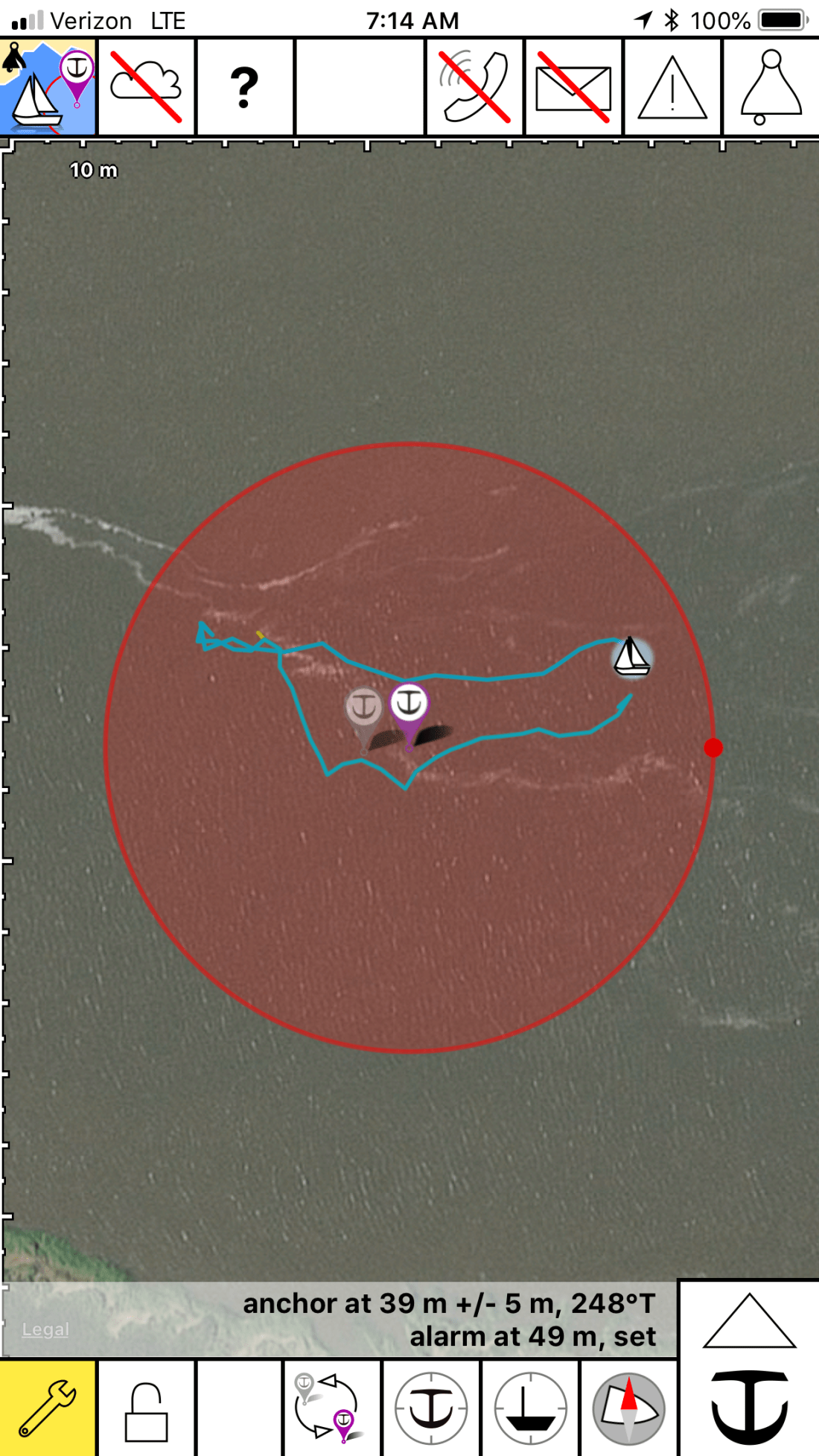
The anchorage was quite busy and the only spot we found was one tucked between two other anchored boats. I had to anchor in an area that had oyster shells and mud. Not a strong seabed for anchoring. The anchored dragged a bit as we set it at 700 RPM. I backed off a little on the throttle and this would have to do for the night. I was tired and needed sleep.
I set the anchor alarm app on my phone and drifted off to sleep.
Anchor Alarm App plays warning sounds if you drag outside of the red circle
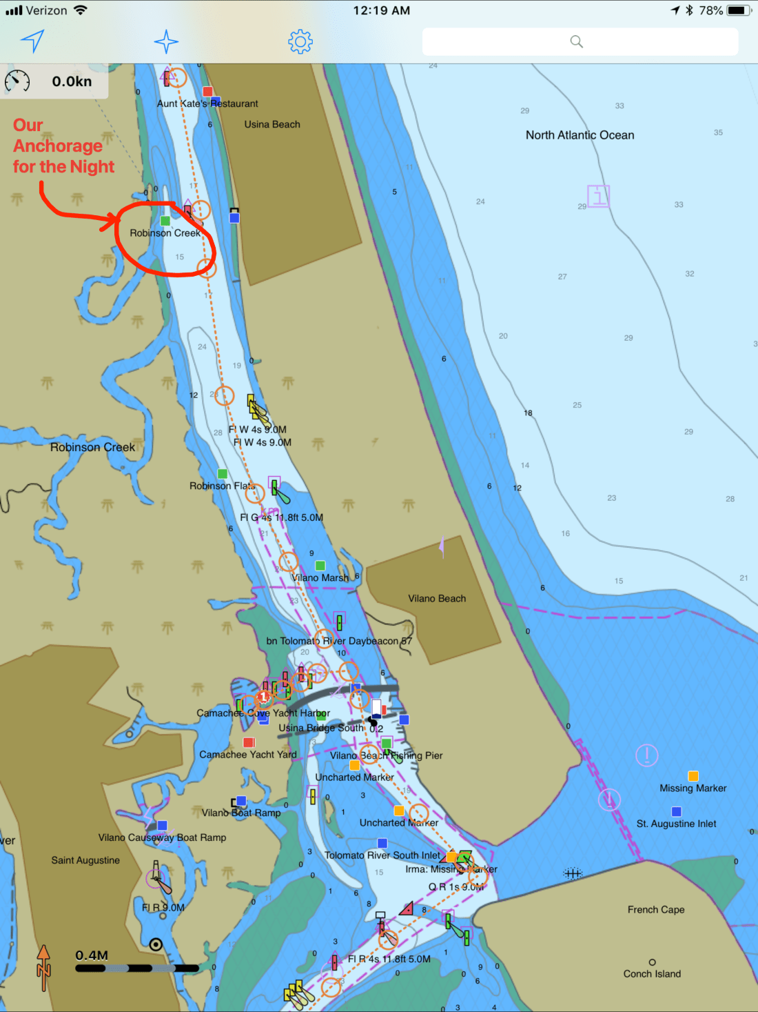
Making our way North our next anchorage, a little creek called Robinson Creek. This spot lies just North of Comanche Cove Marina in St. Augustine, FL. We stopped at Camanchee Cove for a few days on the way down.
Robinson Creek Anchorage
Our route would look something like this.
Route from Oak Hill to Robinson Creek
On our way there we passed through Daytona Beach and the airport had lots of planes flying overhead.
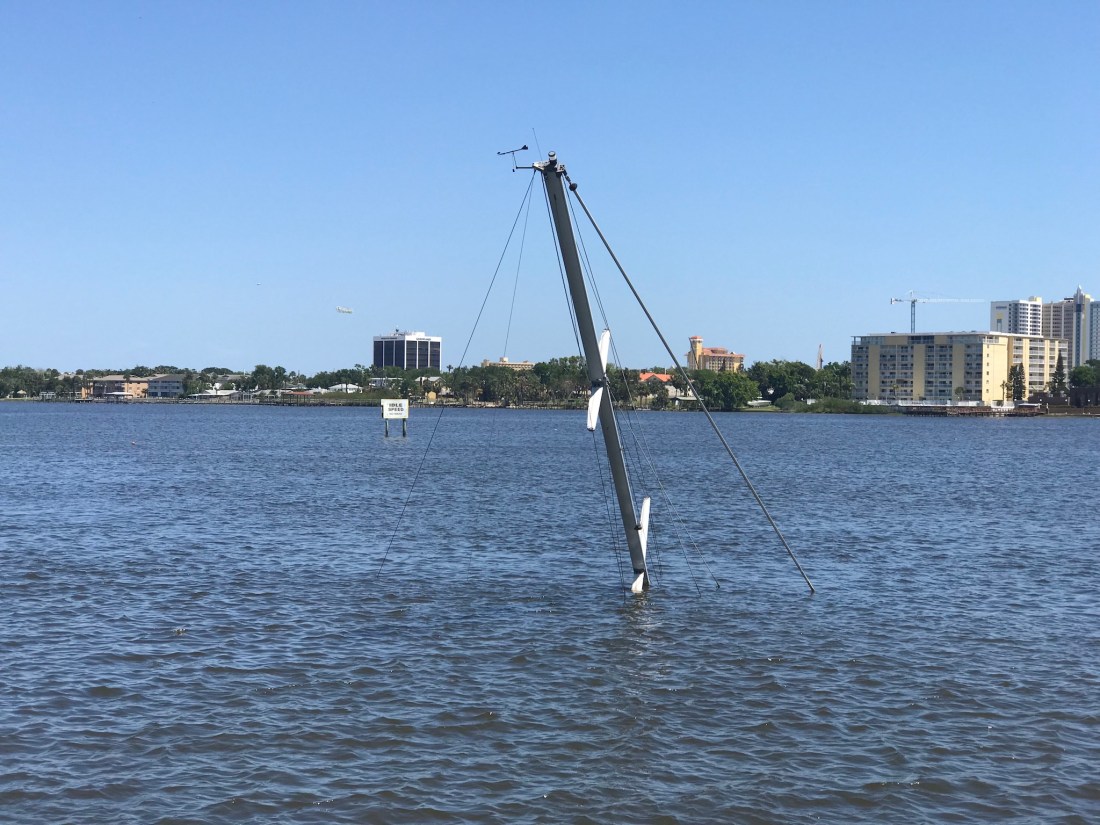
There were other hazards to watch for like this sunken sailboat. Just look for the mast 😉
Sunken Sailboat near Daytona Beach
As we traveled I trawled a fishing line from outside the pilothouse door. I heard the drag on my reel start zzz-zing and reeled in a what I would later identify as a “Ladyfish”. I quick fish app check and this is an unregulated species with poor edibility.
Ladyfish
Fish Id app
in New Smyrna Beach we had to pass under a few low bridges.Our 22’ air draft it made for a tight squeeze. Luckily the bridge is a bit taller in the middle than what is reflected by the height board.
New Smyrna North Causeway Bridge on the ICW
As we approached a bend in the ICW we saw two boats blocking our path to the North. One looks like they have thrown out an anchor to stop from getting pushed further ashore or a possible kedging off attempt. The other was in the process of being pulled off by TowBoatUS. We contacted the Towboat Captain on VHF and treaded water for about 20 minutes until the first boat was pulled clear and we could continue. The trick needed to pass was to hug the reds as close as 10′ abeam. Seems odd that the deeper water would be on the inside of the bend but was where you needed to be. This is location is right near Fort Matanzas South of St. Augustine, FL
The song playing in the pilothouse is “Devil’s Dance Floor” by Flogging Molly. A great Celtic band out of LA.
Anchored to a cloud
Lying STBD Side
Fort Matanzas Anchorage Near the Shoal
Every captain knows when you traverse the ICW, the shallow channel depths mean that you could run aground if you drift out of the channel. For this reason oncoming boats must stay “Right of Center”. This fellow captain seemed oblivious to that rule judging by the wave he gave after forcing us out of the channel. We were riding the right edge of the channel and had no choice but to either hold our ground and use sound signals (1 short blast for a 1-whistle pass – port to port) or simply move over. If you don’t know to stay right of center you wont know your sound signals either 😉
As we approached St. Augustine we saw a large trawler aground.
Large trawler aground just South of St Augustine, FL
Up early, we weighed anchor at Bluefish Point anchorage and headed North.
Our route would take us something like this..
As we were transiting Haulover Canal I had to laugh as I was flashed by a bird.
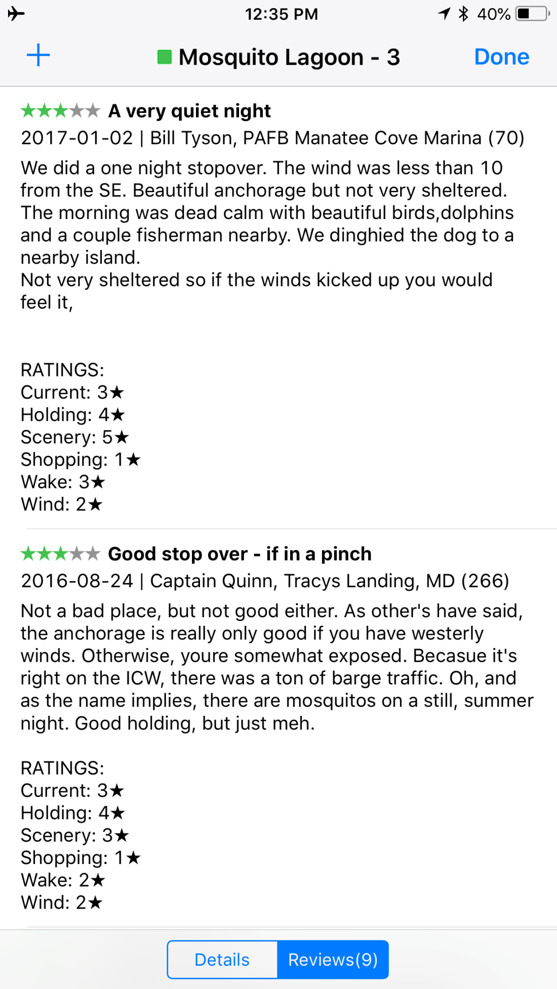
We decided on an anchorage called Mosquito Lagoon (I know, not a inviting name).
This lagoon is near Oak Hill, FL and has many fish camps where local fishermen have camps along the shore.
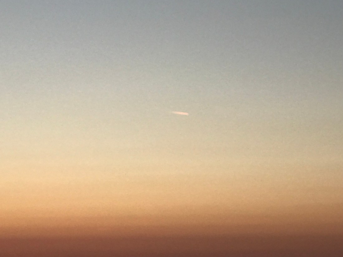
While listening to the VHF the USCG was warning about restricted areas around Cape Canaveral to the South of us. There was a SpaceX launch or their Titan 9 rocket and we wanted to be on anchor with a view for when it started.
Seeing a rocket fly over your head is both impressive and a bit unnerving.
Shortly after the launch we saw what may have been a re-entry from the reusable parts of the rocket? Something SpaceX pioneered.
No sooner had the rocket passed overhead and we were treated to a beautiful sunset and a present moon.


You must be logged in to post a comment.