Chesapeake City

Magnum Controller Fault

Stop Touching Things

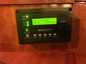
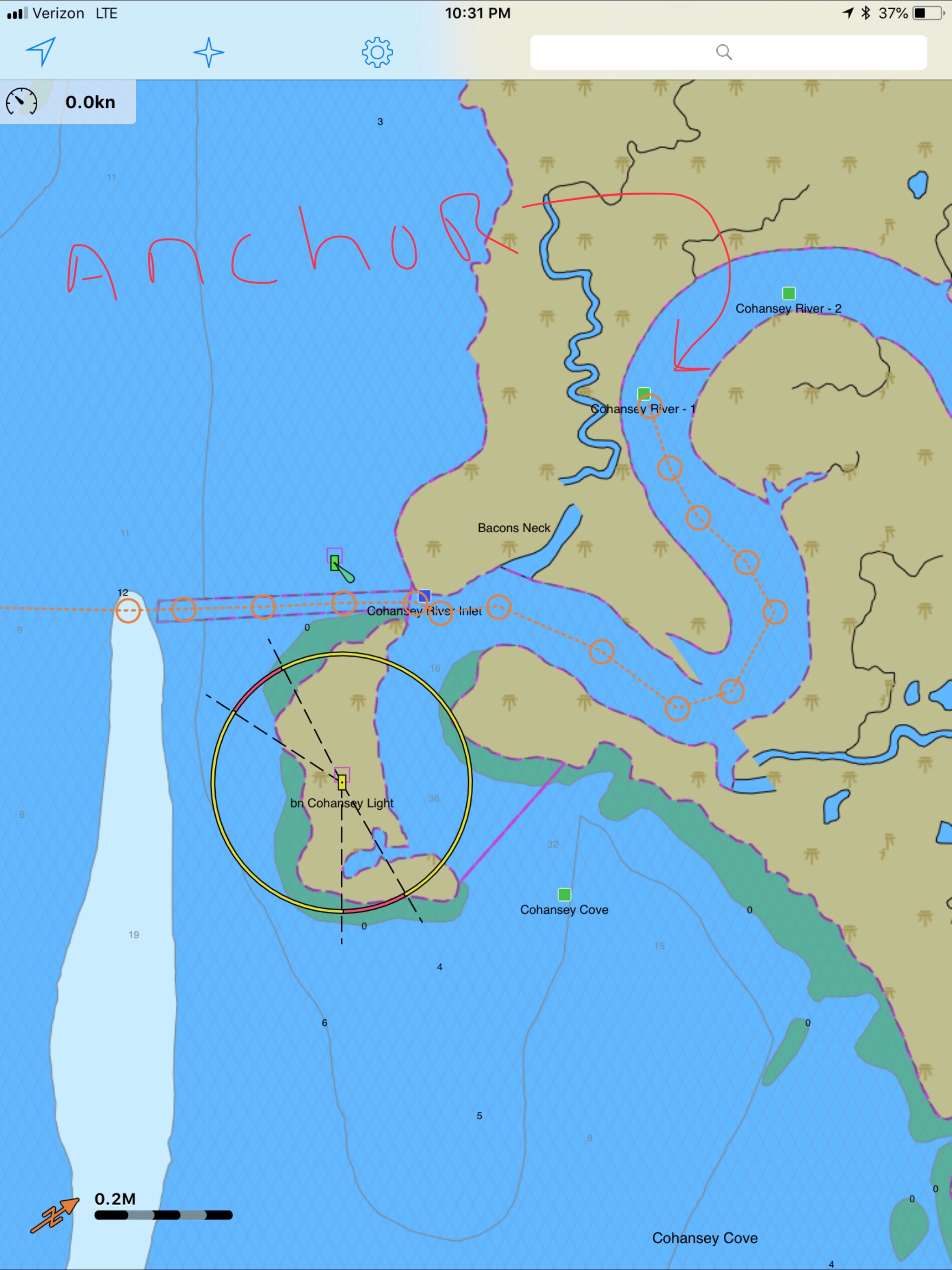
We awoke on anchor and I started the genset to recharge our house battery bank. Standing there in the pilothouse, I could not resist getting into the setup of the Magnum Energy Inverter Charger controller. There are just so many electronic gizmos aboard each with a plethora of controllable settings. Just then the power went out. Coincidence or should I stop randomly changing controller settings to observe the effect?

It took me a while of searching but I found the culprit…

a tripped circuit breaker. My guess… we are running the reverse cycle heat on the 240V AC compressors and the startup of the compressor draws a lot of juice.

Nuclear Power


Our trip up Delaware Bay sent us by the Salem & Hope Creek nuclear power plants. Their cooling tower belching puffy steam clouds set against a blue sky. There are two different nuclear power generating plants next to one another. Salem which has two pressurized water reactors (PWR) and Hope Creek which has one boiling water reactor (BWR). The main difference between a BWR and PWR is that in a BWR, the reactor core heats water, which turns to steam and then drives a steam turbine. In a PWR, the reactor core heats water, which does not boil. This hot water then exchanges heat with a lower pressure water system, which turns to steam and drives the turbine.Together these power generation stations share a large artificial island at the head of Delaware Bay. With it’s combined output of 3,572 megawatts, the Salem-Hope Creek complex is the largest nuclear generating facility in the Eastern United States and the second largest nationwide.

C&D Canal


C&D Canal Location

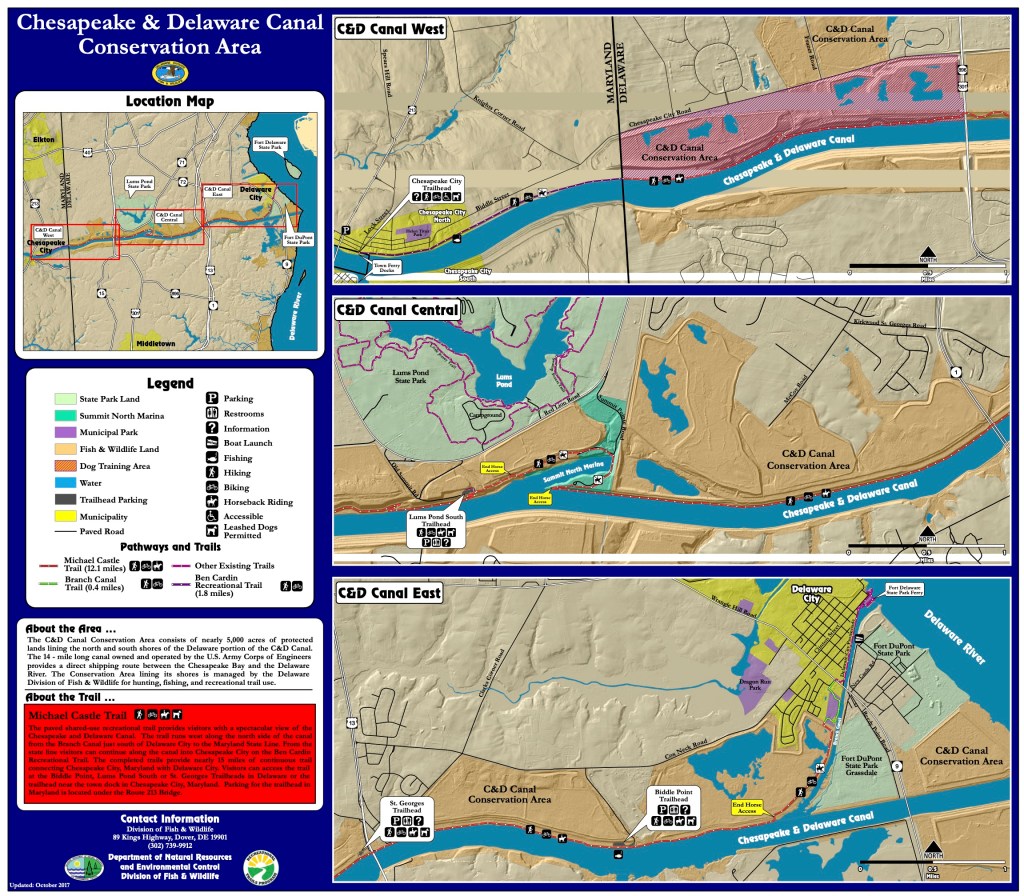
When you reach the head of Delaware Bay, there is a man-made land-cut called the the C&D Canal (shown as the red line in the picture on the right).

The Chesapeake and Delaware (C&D) Canal connects the Delaware River to the Chesapeake Bay.  The C&D Canal system provides a continuous sea level channel (ie. no locks needed) connecting the Port of Baltimore to the ports of Wilmington (DE), Philadelphia, and the northern trade routes. 

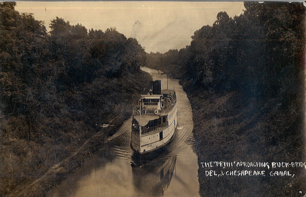
I believe the canal originally opened in 1829. I have included a picture of the steamship Penn as it traversed this early version of the C&D Canal.


Circa 1829

Steamship era Penn making her way down the early C&D circa 1829

This canal is currently a government 1935 authorized project given to the US Army Corp of Engineers (USACE).

The waterway channel is 35 feet deep and 450 feet wide, extending from Reedy Point on the Delaware River, about 46 miles below Philadelphia, PA, through a land-cut westward to Elk River and onto deep water near Pooles Island in the upper Chesapeake Bay.

Delmarva

I suppose it makes the DelMarVa (DELeware, MARyland, VirginA) peninsula more of an island? The Delmarva is a peninsular region 180 miles (290 km) long in the eastern US that includes Delaware, the Eastern Shore of Maryland, and a small strip of Virginia; it separates Chesapeake Bay from the Atlantic Ocean.

C&D Canal Map
C&D Canal East End

As turned to port and entered the C&D Canal. There were many locals walking the banks of the canal.

The towns have set aside the area along the bans as conservation land. It’s a peaceful area with the land high above you blocking the wind as you walk the banks waving to passing yachts.

We toot our air horns and receive waves from the locals as they stroll along.


Free Dock

We planned to dock at the free town dock in Chesapeake city. The town set this small dock aside for boating visitors to their town. Simple Life’s 58′ LOA makes her tougher than her previous namesake to slip into open space at a face dock. As luck would have it… We found an opening and eased her up to the dock and had to lasso the cleats from on board as our decks are too high to simply jump down onto the dock.

Chesapeake Town Dock – Are those Xmas lights?

Downtown

We quickly jumped off and wandered the pocket-sized downtown area.

Where to Grab Dinner?

Chowder

We walked into a restaurant called Prime 225 that a friend told us to visit but sadly… it was a 3 hour wait!

A block away we discovered a quaint local hangout call The Tap Room. I grabbed a burger and T had the chowder. Food was good but it wasn’t the right vibe and their Goose Island IPA is OK but not my favorite.

Where to next?

When we landed on the town dock we could see a marina restaurant just 400 feet away on the tiny harbor. We walked in that direction till we saw…


The Deck

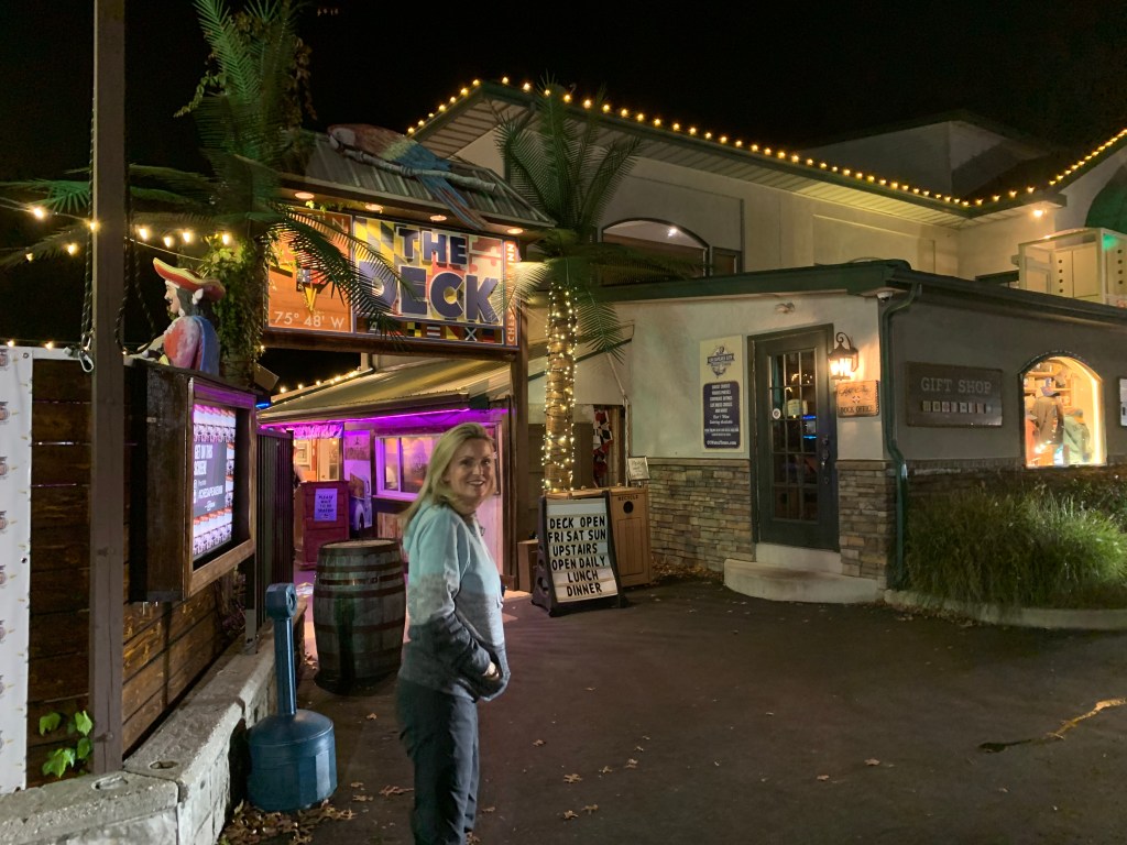
As we passed beneath the sign we were greeted with the sounds of a live band singing some Fleetwood Mac – Dreams.

We band was good and the IPA was better 😉 As the band played we played “Name that tune” while I shot out to a quick lead with Fleetwood Mac it seems the band conspired with Teresa to play her music and I believe she won by a landslide in the end.

The walk back to Simple Life was short and we where thankful for that.

La Mañana Siguiente

The town dock is free but if you plug into electricity like we did you must pay the town hall just 1 block away. So off I went to stuff an envelope of cash through their mail slot as it was Sunday.
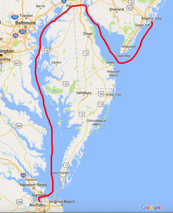
Leg Seven

The seventh leg of our journey south looked something like this…

Delaware Bay

The morning started with me readying the dinghy to be hoisted onto the flybridge. I attached the dinghy hoisting harness and untied the dinghy and walked up to the flybridge to operate the crane. I no sooner had the crane control in my hand and I looked out to see the dinghy floating away. Apparently, I had attached the lifting harness to the dinghy and not connected the crane’s hook to the harness. Oops. I had to quickly start the engine, untie from my mooring and chase the dinghy down as it was blowing across the harbor. We caught up with it just in time and used a boat hook to grab it. Crisis averted.

As we pulled out of Annapolis harbor this father, son, dog team passed us.

Guy Son 1
Father, Son, Dog Boating at it’s best

A quick check of the weather showed the SCA (Small Craft Advisory) was going to stick around for a few days.

2 SCA.PNG
SCA

As we proceeded North up the last bit of Chesapeake Bay you see many structures like this.

3 Structures in CB
What is it? I dunno?

A quick check of the currents showed me that I better increase my speed to prevent an unfavorable current while transiting the C&D canal.

4 CD Currents.jpg
C&D Canal Current Table

Entering into the C&D canal you see many interesting sights.

When you study the charts you’ll see things that cross canals like bridges and overhead power cables. When I saw an “overhead pipeline”, I was intrigued.

I also so these lighted poles that I’m guessing make navigation easier at night. These poles will also generate radar pings in areas where the canal is shallow. Without these light poles, you could imagine a ship accidentally straying outside of the dredged channel in the areas where the shoreline extended far from the channel.

CD canal lights
C&D Canal Lights

Soon we exited the East end of the C&D Canal and we turned South down Delaware Bay.

South
It’s frustrating to spend two days heading South when you are trying to get North

As we approached our anchorage the sun began to set and I was so busy trying to navigate in the small cut on the West side of the barrier island that blocks the entrance to the Cohansey River. I was so busy at the helm, I could only manage a single picture.

Sunset
Sunset in Delaware Bay

Soon we were anchored in the Cohansey River and the waves of Delaware Bay were held at bay by the river’s banks. While the river has a strong current, the river bottom has proven to have good holding power.

Delaware Bay has some interesting facts. It is home to many horseshoe crabs and their numbers are dwindling due to horseshoe crab harvesting. Not for eating, though you can eat their eggs or roe but for their blue blood. That’s right, horseshoe crabs have brilliant blue blood due to copper that carries oxygen in their bloodstream. This is very similar to the red hemoglobin that carries oxygen in our human bloodstream. Research scientists in the medical field harvest their blue blood for it’s ability to react to the presence of bacterial endotoxins. This unique ability allows medical professionals to detect bacteria in many places.

Horseshoe-crab-blood-harvest-11
Harvesting the Blue Blood of Horseshoe Crabs

Delaware bay is also home to the Red Knot bird. The red knot has one of the longest migrations of any bird. Every year it travels more than 9,000 mi (14,000 km) from the Arctic to the southern tip of South America. The exact migration routes and wintering grounds of individual subspecies are still somewhat uncertain.

Red Knot
Red Knot – A.K.A. Calidris canutus rufa

Lastly, Delaware Bay is home to a phenomenon called “Sand Waves”. This is where the sand on the bottom of the bay forms a wavy bottom surface. The wave patterns that sets up are static and have reached an equilibrium. The sand waves cause larger water waves on the surface. It’s interesting to see on your sonar picture as you go over the top of these sand waves. We saw this very same sand wave phenomenon on our sonar at the mouth of Chesapeake bay.

Sand Waves Chart
Sand Waves Depicted on my Chart

Sand Wave SF Bridge
Sand Waves West of the San Francisco Bridge

Chincoteague Island, VA – Where are the Ponies?

We awoke around 4AM this morning and I began pouring over the charts until I felt comfortable that we could safely make the passage down the outside passage to Norfolk, VA in 4 separate legs. By staying outside we will save days if not a week of traveling inside through the Chesapeake. While we would like nothing more than to spend months exploring all the great places in Chesapeake Bay, right now we could go for some Key West sunshine.

The other day we left Atlantic City and motored past the mouth of Delaware bay, I just could not bear to make a starboard turn and head up the Delaware Bay. This would mean heading North rather that South. In order to take the inside passage you must first run North up the Delaware Bay till you get to the C&D canal that connects the head of Delaware bay with the head of Chesapeake Bay. Once in Chesapeake Bay you again start heading South. It’s quite a bit longer than simply staying outside in the Atlantic Ocean.  It’s also more work for the captain, who must stay vigilant to avoid other boat traffic as well as steer around lobster pots. Nobody likes getting a lobster pot line wrapped around their propeller. We installed a “shark” pot cutter in front of our propeller to hopefully chop any lines that tangle in our propeller.

shaft shark
“Shark” Pot Cutter in Front of Propeller (Similar to MV Simple Life’s Setup)

Inside Passage Map
Inside Passage – Up Delaware Bay, Through C&D Canal and down Chesapeake Bay

4 legs map
Outside Passage – 4 Legs, 2 Anchorages

The more we studied the few inlets along the outside passage, the more we realized that many of them were possibly full of shoals and shallows to be worth trying to enter. There were some that if we did enter the inlet, it was clear that once inside it we could easily run aground due to the shallows that abounded. It was also very evident to us that our 2012 electronic charts no longer match the current depths and shoal locations. I use the charts as a “guide” but keep a close eye out for breaking waves where a new shoal may have formed due to recent storm activity.

We arrived at Chincoteague Island sometime around 1PM. The journey here was pretty uneventful. We saw only one other boat and it was a large sport fishing yacht moving at twice our speed South down the coast.  We studied the charts and found a nice spot to drop hook, close to the shore. MV Simple life has a 90 lb. Rocna, plow style anchor and 300′ of 3/8″ chain. I let out almost 120′ which was a ridiculous amount of scope (“anchor scope” is a ratio like 7 to 1: length of chain compared to depth of water). If we were in a crowded anchorage we’d never be able to let out that much scope as when the wind changed direction we’d swing into other boats. Along this coast there is not another boat in sight. After the anchor hooked up I applied some throttle in reverse (+200 above idle, or 800 RPM) which combined with the strong wind, buried the anchor. The extra throttle  lifted the chain straight out of the water with no bounce. We believe you should always “back down” on your anchor and watch to see if the chain jumps up/down which is a clear indication that the anchor is dragging along the bottom. This can happen for many reasons but some possible causes can be the seabed could have eel grass that stops the anchor from “digging in” or the bottom might not be sandy but instead a super soft silt that is like pushing a potato chip through whip cream instead of thick cheese. Better to have your anchor drag while you’re backing down on it than when the wind picks up in the middle of the night and you are fast asleep.

Chinoteague map
Red X is Where we Anchored – Off Wallops Island. Chincoteague outlined in Red

After reading about the wild ponies on Chincoteague Island, I made up my mind to use the crane and drop the dinghy in the water to go find them ponies. I had no sooner raced off on the dinghy before I thought.. I’m freezing & I’m zipping along over the shallow shore and could easily run aground at full speed and wind up taking a dip in the cold Atlantic. So I put a lifejacket on and turned around and made it back to the Simple Life. DAMN, NO PONIES!!!

Back at the boat the heater was on and I quickly put the dinghy back on the flybridge and warmed up to an IPA 😉 That brings me to where I am now.. sitting in the pilothouse enjoying a beer or two. We’ll leave you with our sunset view — good night.

Wallop Island Sunset