Cumberland Sound Anchorage

As we weighed anchor in Robinson’s Creek you could feel the power of the wind. The airport wind speed last showed a 30 MPH gust.

30 mph Wind Gusts at NE FL Regional Airport
25 MPH Winds with 30 MPH Gusts as we passed NE Florida Regional Airport


Even with the strong winds a pair of US Custom agent boats zoomed by, unaffected.

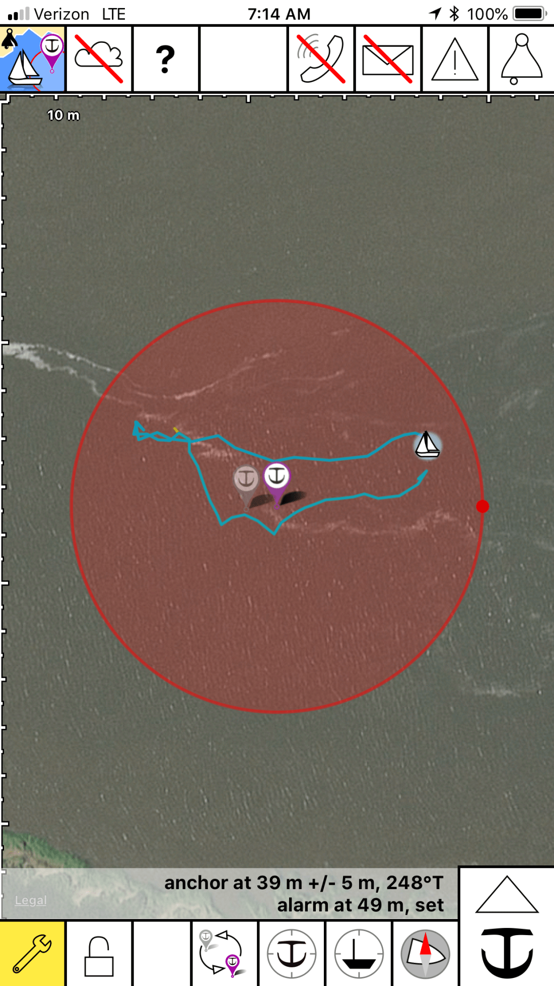
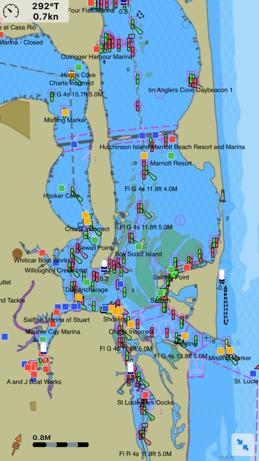
Our route would look something like this:

Route 4 - Robinson Creek - Cumberland Sound
Our Route from an anchorage in St Augustine to Cumberland Island Anchorage

We would avoid many shoals:

South Sapelo River
Shoal near South Sapelo River.

We would cross over the St. John River in Jacksonville, FL and see sights such as this Navy ship in dry dock. What a narrow beam and sharp bow these attack vessels have.

St Johns River Battleship
Navy Ship in Dry Dock

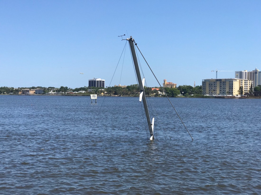
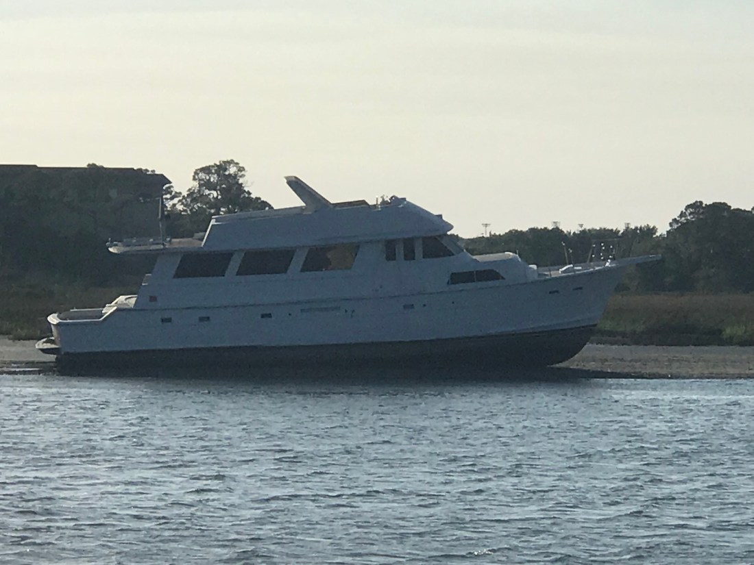
I had always wondered what a trawler would look like with a wind generator mounted on the fly deck and I just have to say I can’t imagine ever doing this..

Trawler 3 Wind Generators
A trawler with 3 Wind Generators on the Flydeck

The free overnight dock in Jacksonville had a spot open but we were determined to use what we had left of the light and cover more ground. Our plan was to cross over the Savannah River and into GA.

Once in the Savannah River we saw that many of the river banks had been built up possibly for storm surge.

Savannah River Tree
Lone Tree standing proud on the banks of the Savannah River

As you approach Cumberland Island there is a heavy Navy presence in the area. We passed these two big Navy ships in port.

Cumberland Island Navy
Navy Ships near Cumberland Island

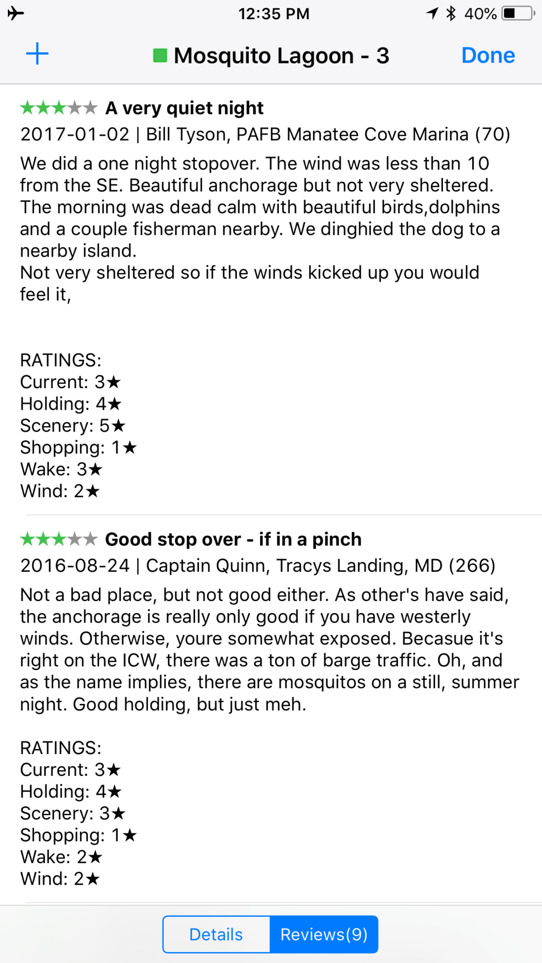
We read the writeup on the Cumberland Island Anchorage.

Cumberland Sound
AC Cumberland Sound Anchorage writeup

We chose this anchorage because it offered a lee in the face of strong winds.

Cumberland Sound Anchorage
Our Anchor spot in Cumberland Sound

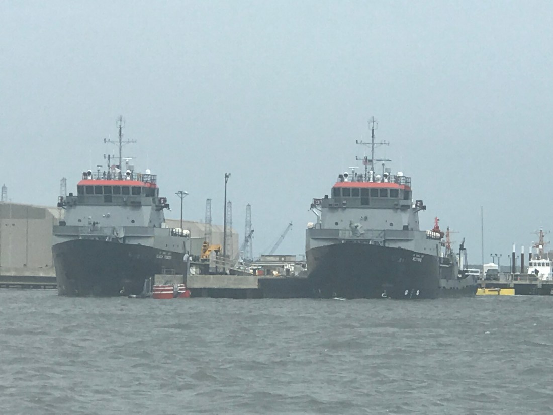
The anchorage was quite busy and the only spot we found was one tucked between two other anchored boats. I had to anchor in an area that had oyster shells and mud. Not a strong seabed for anchoring. The anchored dragged a bit as we set it at 700 RPM. I backed off a little on the throttle and this would have to do for the night. I was tired and needed sleep.

I set the anchor alarm app on my phone and drifted off to sleep.

Anchor Alarm
Anchor Alarm App plays warning sounds if you drag outside of the red circle


Robinson Creek Anchorage

Making our way North our next anchorage, a little creek called Robinson Creek. This spot lies just North of Comanche Cove Marina in St. Augustine, FL. We stopped at Camanchee Cove for a few days on the way down.

Robinson Creek
Robinson Creek Anchorage

Our route would look something like this.

Route 3 Oak Hill - Robinson Creek
Route from Oak Hill to Robinson Creek

On our way there we passed through Daytona Beach and the airport had lots of planes flying overhead.


There were other hazards to watch for like this sunken sailboat. Just look for the mast 😉

Sunken Sailboat Daytona
Sunken Sailboat near Daytona Beach

As we traveled I trawled a fishing line from outside the pilothouse door. I heard the drag on my reel start zzz-zing and reeled in a what I would later identify as a “Ladyfish”. I quick fish app check and this is an unregulated species with poor edibility.

in New Smyrna Beach we had to pass under a few low bridges.  Our 22’ air draft it made for a tight squeeze. Luckily the bridge is a bit taller in the middle than what is reflected by the height board.

New Smyrna N Causeway Bridge_7968
New Smyrna North Causeway Bridge on the ICW


As we approached a bend in the ICW we saw two boats blocking our path to the North. One looks like they have thrown out an anchor to stop from getting pushed further ashore or a possible kedging off attempt. The other was in the process of being pulled off by TowBoatUS. We contacted the Towboat Captain on VHF and treaded water for about 20 minutes until the first boat was pulled clear and we could continue. The trick needed to pass was to hug the reds as close as 10′ abeam. Seems odd that the deeper water would be on the inside of the bend but was where you needed to be. This is location is right near Fort Matanzas South of St. Augustine, FL

The song playing in the pilothouse is “Devil’s Dance Floor” by Flogging Molly. A great Celtic band out of LA.


Every captain knows when you traverse the ICW, the shallow channel depths mean that you could run aground if you drift out of the channel. For this reason oncoming boats must stay “Right of Center”. This fellow captain seemed oblivious to that rule judging by the wave he gave after forcing us out of the channel. We were riding the right edge of the channel and had no choice but to either hold our ground and use sound signals (1 short blast for a 1-whistle pass – port to port) or simply move over. If you don’t know to stay right of center you wont know your sound signals either 😉

As we approached St. Augustine we saw a large trawler aground.

Trawler Aground_8030
Large trawler aground just South of St Augustine, FL

We passed the magnificent schooner Freedom

Freedom

The night ended with a warm orange-pink sunset.

Robinson Creek_Sunset
Sunset at anchor in Robinson Creek

Mosquito Lagoon Anchorage

Up early, we weighed anchor at Bluefish Point anchorage and headed North.

Our route would take us something like this..

Route 2 Bluefish - Oak Hill

As we were transiting Haulover Canal I had to laugh as I was flashed by a bird.

Haulover Canal Flasher Bird

We decided on an anchorage called Mosquito Lagoon (I know, not a inviting name).

Mosquito Lagoon

This lagoon is near Oak Hill, FL and has many fish camps where local fishermen have camps along the shore.

Oak Hill Camp.JPG

While listening to the VHF the USCG was warning about restricted areas around Cape Canaveral to the South of us. There was a SpaceX launch or their Titan 9 rocket and we wanted to be on anchor with a view for when it started.

Seeing a rocket fly over your head is both impressive and a bit unnerving.

Shortly after the launch we saw what may have been a re-entry from the reusable parts of the rocket? Something SpaceX pioneered.

Oak Hill reentry_7934

No sooner had the rocket passed overhead and we were treated to a beautiful sunset and a present moon.

Vero Beach Heading North

After coming out of the Okeechobee Waterway we anchored just off Hutchinson’s Island. This anchorage is just inside the St. Lucie Inlet and while it’s not an official anchorage, it worked for us.

Anchorage Marriott

Our crew was was looking a little banged up. Kelly with a broken toe (again)

Kelly Toe

Chief Martin Brody with a sore paw after ripping a claw off one of his toes.

Thankfully the captain survived to patch the crew back up.

As departed Hutchinson’s Island and made our way North towards Vero Beach I did some quick math on our speed and expected time of arrival. We had told the Suntex Marina in Vero Beach that we would be there before 5PM. With the late start that meant that we were going to have to burn a little fuel and step up our speed from a leisurely 6 kts to something North of 8 kts.

Having dolphins on your bow is something that happens daily in Southern Florida.

Soon we were docked in Vero Beach and it was time to go out to dinner with Lori & Jim @ the Bonefish grille. The food was great and we always have a blast hanging with Lori & Jim.

Back at the marina I found another North Pacific 43. This couple is from Canada and they have some interesting modifications to their NP43. For one they added backup mirrors to the outside of the life rails (I wonder if you can actually use these backing in from the pilothouse?).

I also found a fellow boater from Duxbury, MA here in the Marina.

While we were in the marina the weather turned stormy. Sitting in the pilothouse you could see the wind blowing hard over the water’s surface.

From our aft cockpit you could stay dry as the rain poured down.

We even got some hail hitting the boat and landing in the cockpit.

We had lots of fun in Vero Beach but alas we must keep making our way North to get home and see more family and friends. As we headed out onto the ICW we past many beautiful homes that reminded us how nice Vero Beach is to visit.

Miami and Key Biscayne

We enjoyed Fort Lauderdale and especially having family come to visit.EdDoKellyMarty

We hit some of the local restaurants like…


One night while on anchor a fellow cruiser from another boat came to visit and him and I chatted about the Bahamas and where to go. At 80 years old he and his wife had crossed over to the Bahamas countless times and he was nice enough to give me a map of interesting places to visit. I enjoyed that time and had a great selfie of the two of us to post here but unfortunately, I locked myself out of my phone and had to wipe and restore it losing the pics 😦

Our anchorage in Lake Sylvia had some amazing homes to look out at.

Occasionally we would see a floating tiki bar go by…

Tiki

Next we anchored in Maule Lake in North Miami Beach.

We were enjoying the 80 degree days and cool breeze at night. We took the dink out to find more fun restaurants like Duffy’s.


There was a great abandoned park where I was able to land the dinghy. Time to do some re-provisioning.

IMG_0135

Dingy full of required stuff, it was time to get back to the mother ship.

IMG_9164


We keep waking up every morning and deciding to stay a bit longer till we realized that we need to be halfway down the keys in a few days so it was time to weigh anchor and get underway. The trip down the ICW took us past Haulover Sandbar.

Haulover Sandbar is a popular party spot in Miami and with it being Spring Break down here it is sure to come alive. We’ll have to stop on our way back from the Keys.

Random Haulover Sandbar YouTube Video


Tonight, we anchored in Key Biscayne Bight just as the sun was setting

KB0

The full moon made for a great night sitting in the aft cockpit and enjoying a few drinks.

KB1