Leaving Atlantic City, the predicted forecast was for 4-5′ waves on our stern as we travel south to Cape May. Normally we wait for 2-3′ waves as 4-5 footers can be uncomfortable especially if they are on your beam. However, if we didn’t get out of AC on this particular day… the Atlantic zone between AC and Cape May will have waves in the 7’+ range which is nothing we wanted to travel in. So… Off we went…
The waves heights turned out to be OK and I grabbed a video of our bow wake as we headed out of Atlantic City.
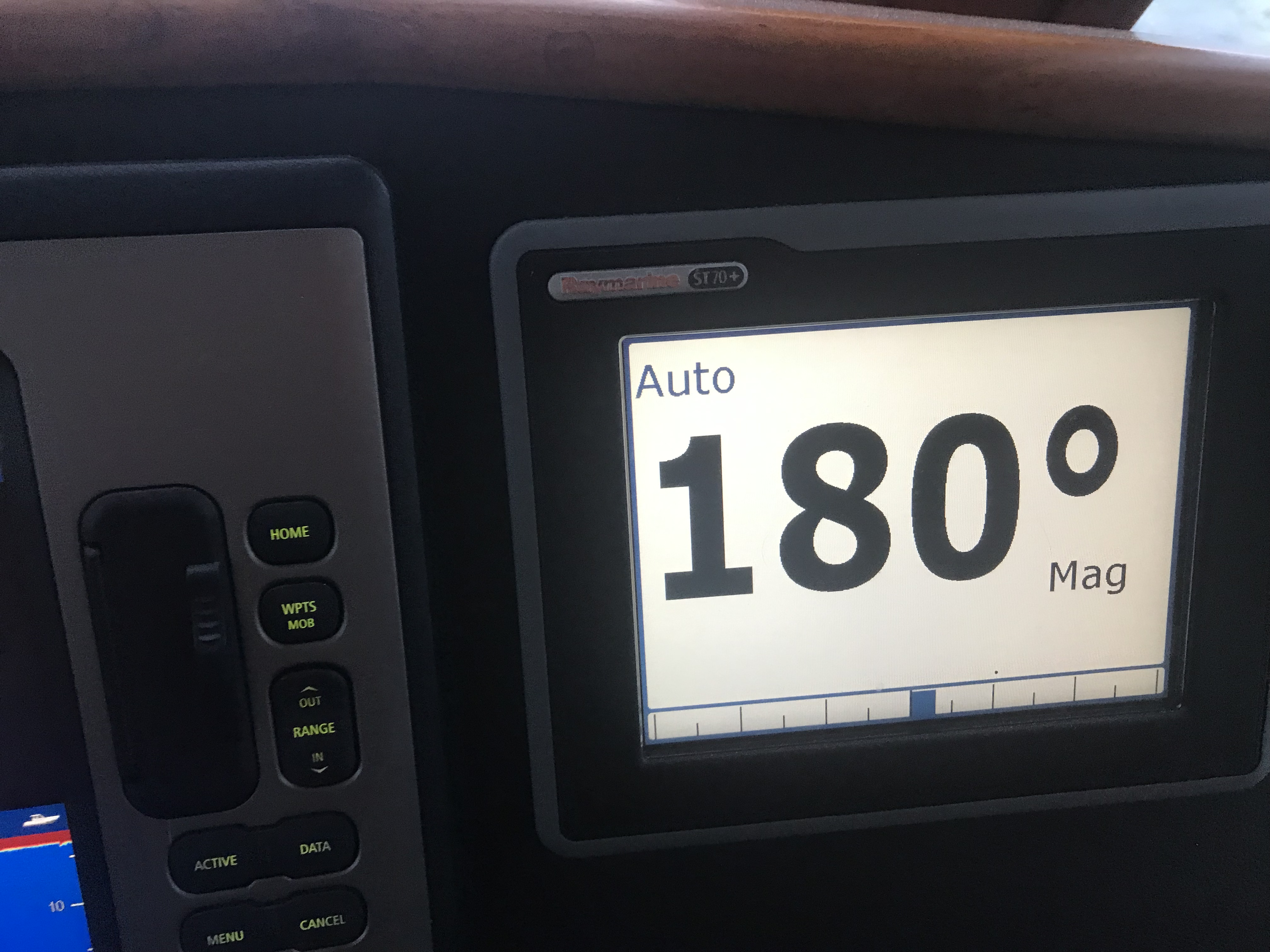
We made good time heading south down the Jersey Shore. We increased speed to 12kts to add more stability to the boat.
Like most trawlers or motor yachts Simple Life has a square (hard chined) hull when you move aft. This is very common as most boats have a sharp V shape under the water at the bow and those steep V hull sides slowly turn horizontal or flat bottomed as you move from the bow to the stern of the boat. This means that the where the sides of the hull meet the bottom of the hull in the aft (rear) of the boat you have a near 90 degree corner.
Have you ever stuck you flattened out hand into the water moving past you while on a boat? If you have, your hand was thrust up and out of the water by the force of the water hitting your hand. If you try pushing your hand deeper into the water it gets pushed back up even harder. As the boat heels to one side or the other… one side of the boat is forced deeper into the water while the other side is lifted out of the water. The faster the oncoming water is hitting the bottom of the boat on the heeled-side the stronger it feels pushed back up, This has the effect of reducing the heeling motion. Likewise the side of the boat that is being lifted out of the water feels less buoyancy force pushing it up by the smaller section of hull still submerged. The forces work to return the boat to level.
Righting Moments
If you take your captains class you will use a diagram like this with metacentric heights and righting moments. It’ll be a more formal discussion like the one found here.
Some times I just like to watch the prop wash that pops back to the surface after being pushed down by the boat riding over it.
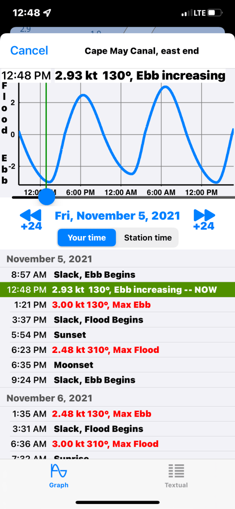
We were approaching the Cape May inlet and we already knew that we would hit the Cape May Canal as it approached maximum ebb current. Not much we could do about that other than throttle up and push through.
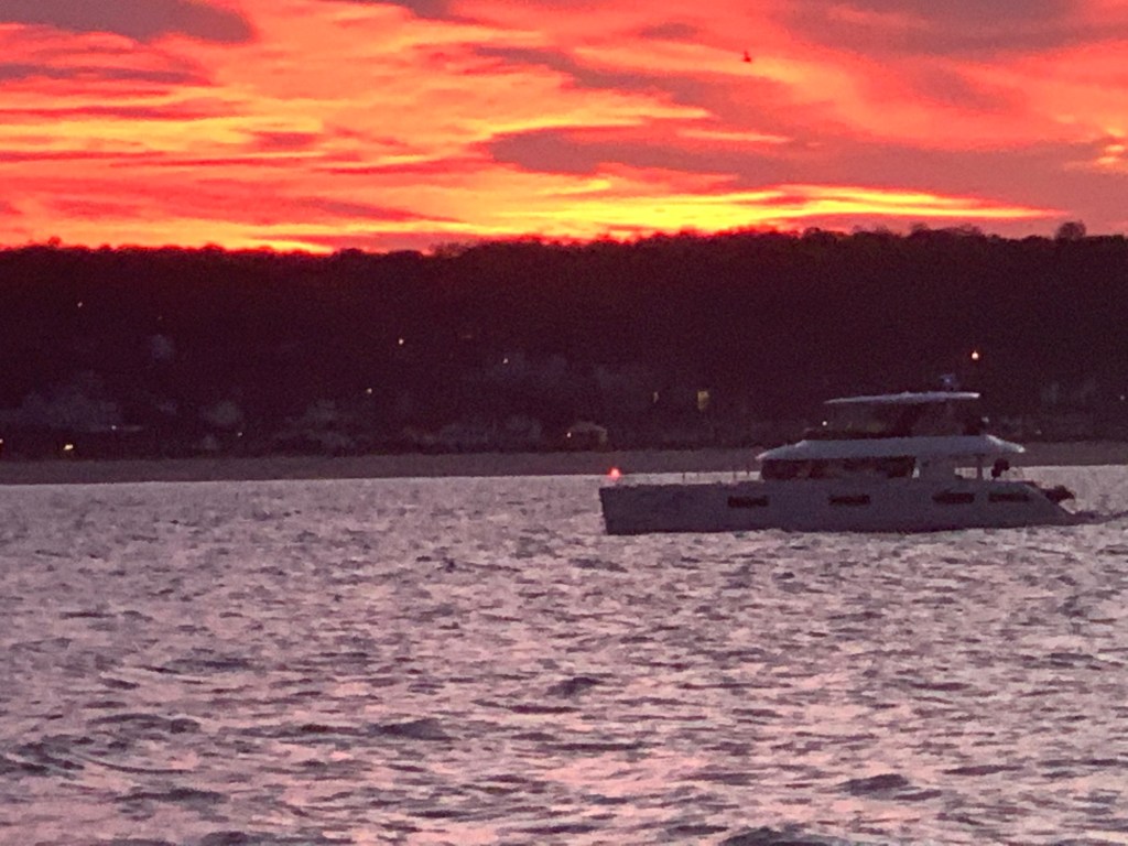
We exited the Cape May Canal and made our way up the Delaware Bay. The ride north up Delaware Bay was uneventful and we passed almost no other boat traffic. Soon we were approaching our chosen anchorage in the Cohansey River. We circled for a bit checking depths before we dropped the hook for the night. We were treated to an amazing red sunset.
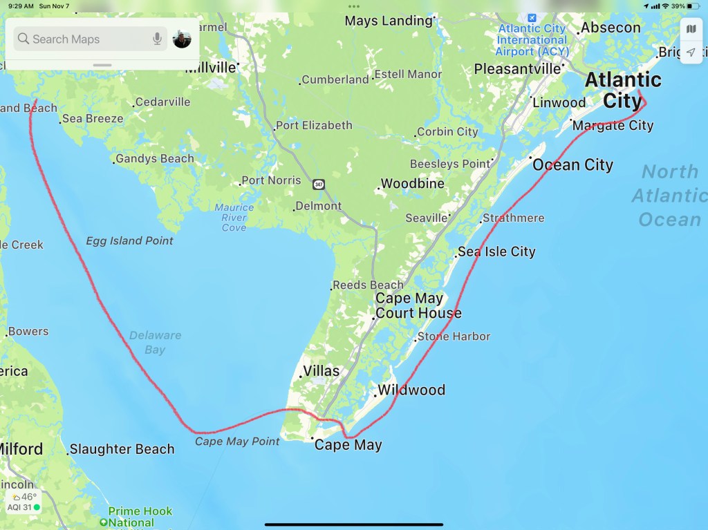
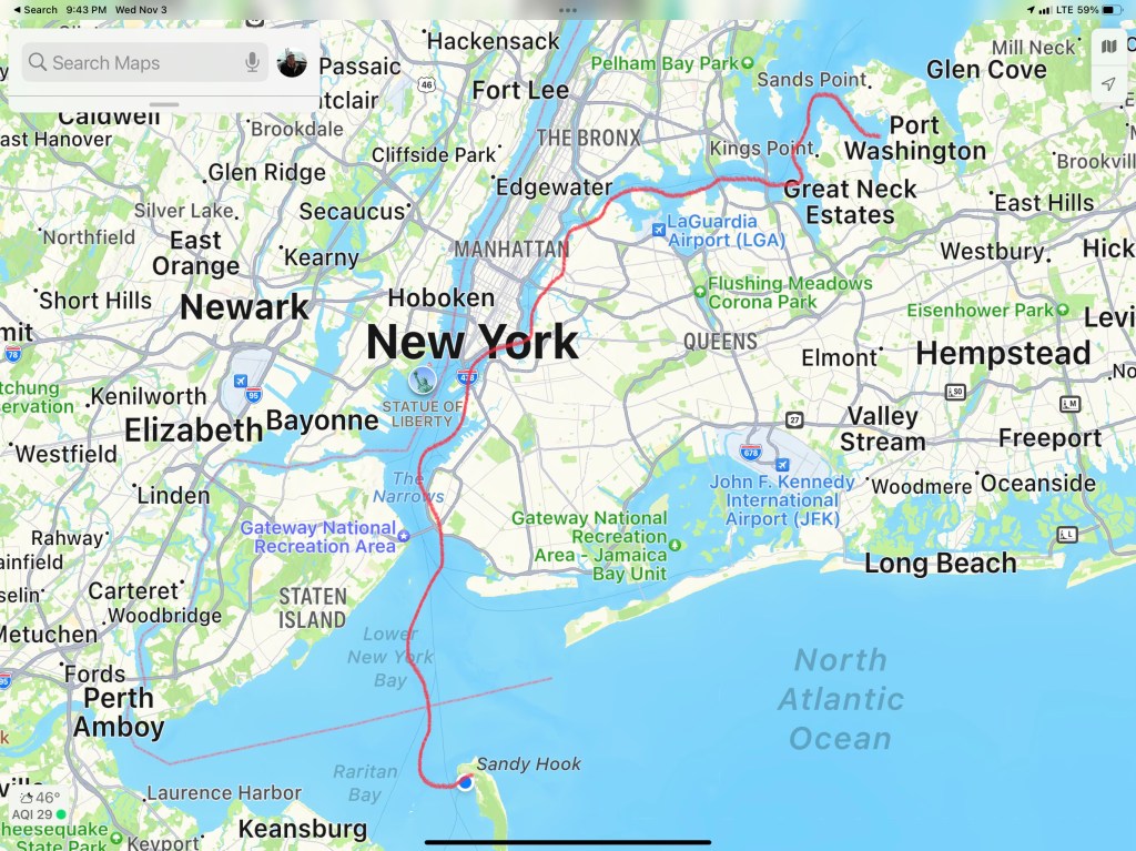
Our route for Winter 05 – Leg 006 looked something like this.
We awoke on anchor in Sandy Hook, NJ. We weighed anchor and got underway by 8AM. The trip down the Jersey shore was peaceful with 2-3′ waves and a 15kts of wind. We cruised south staying about 2 miles off the beach.
We did not see much boat traffic other than small fishing boats that huddled around Manasquan & Barnegat Inlets.
Barnegat light is very conspicuous from this close distance.
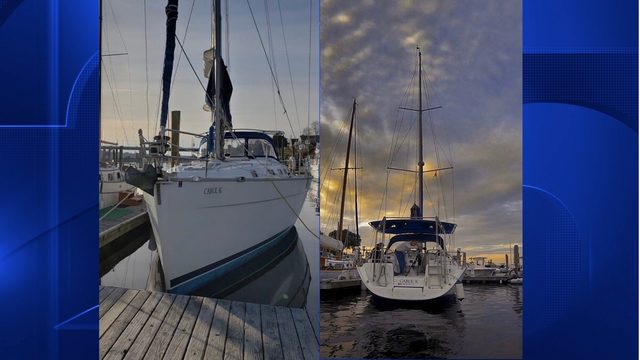
Here at the marina, Simple Life was not the only yacht hailing from a port in Massachusetts.
MV Seaductress
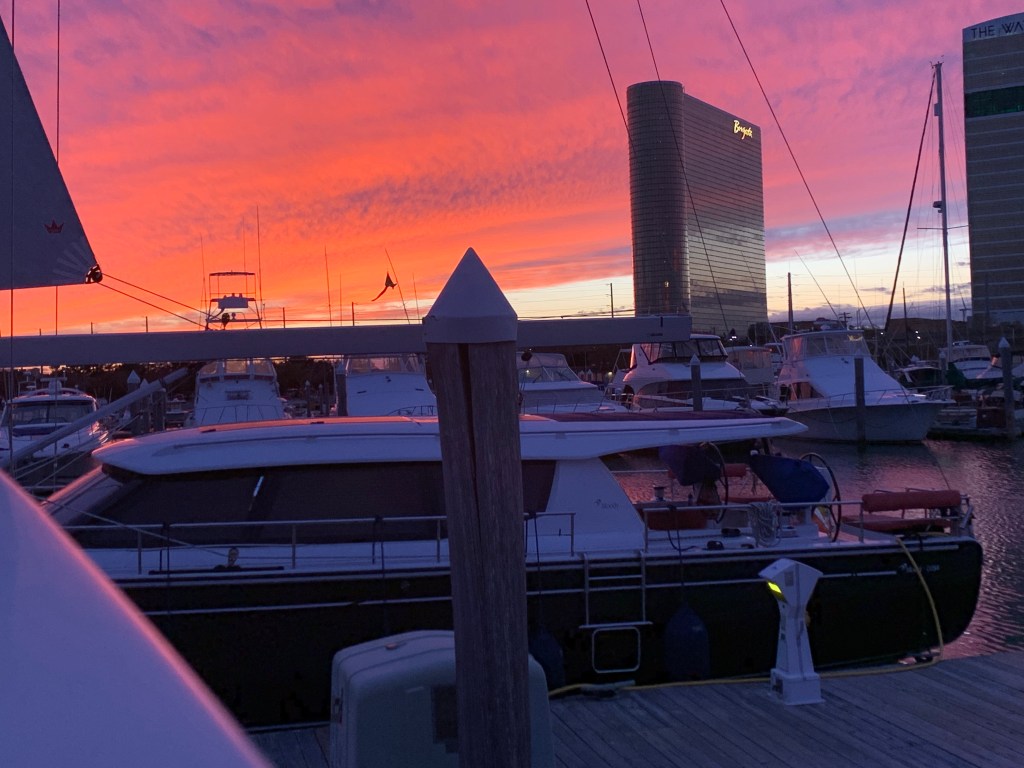
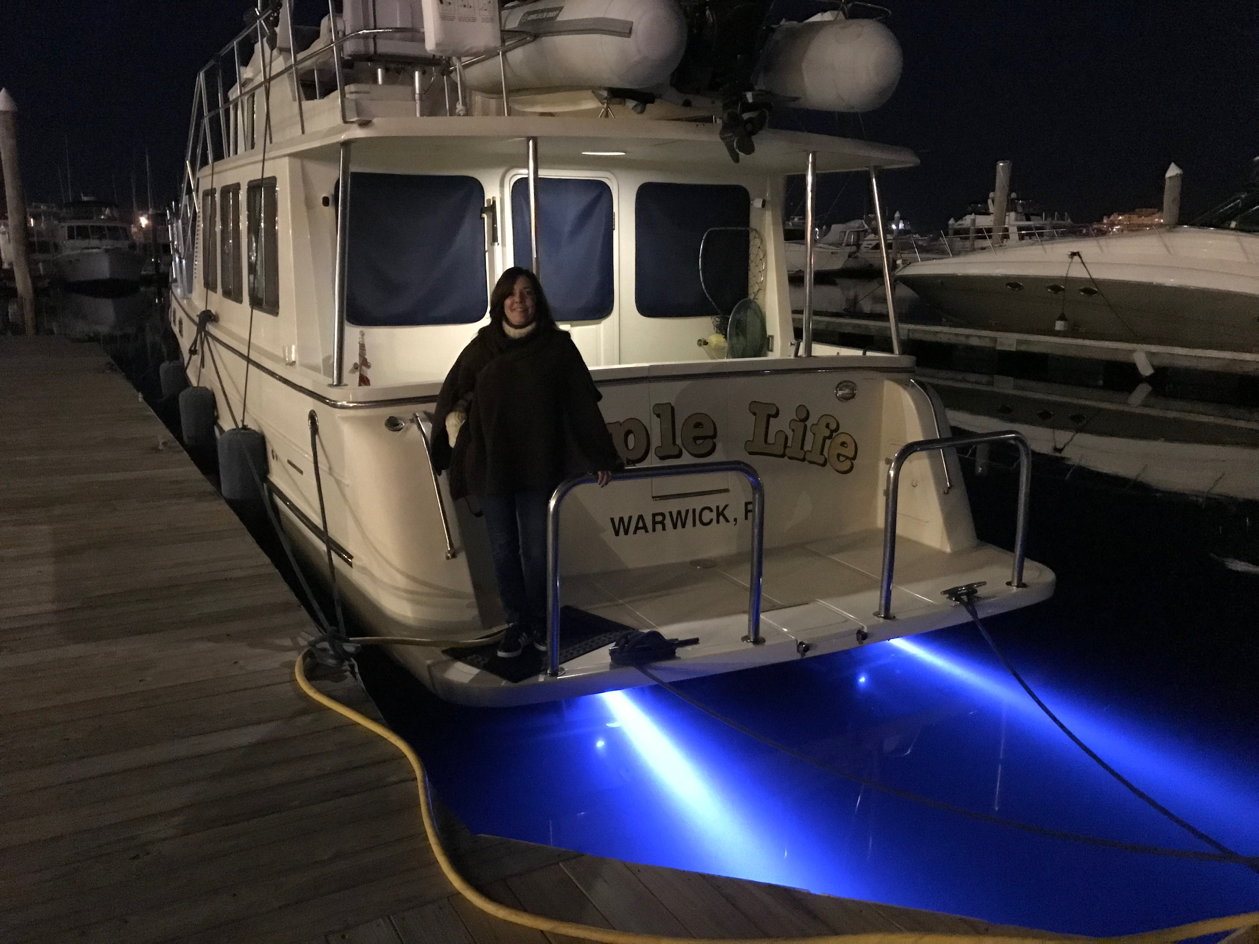
The sun was setting as we tied up the boat.
Golden Hour Cast upon the Yachts
Sunset
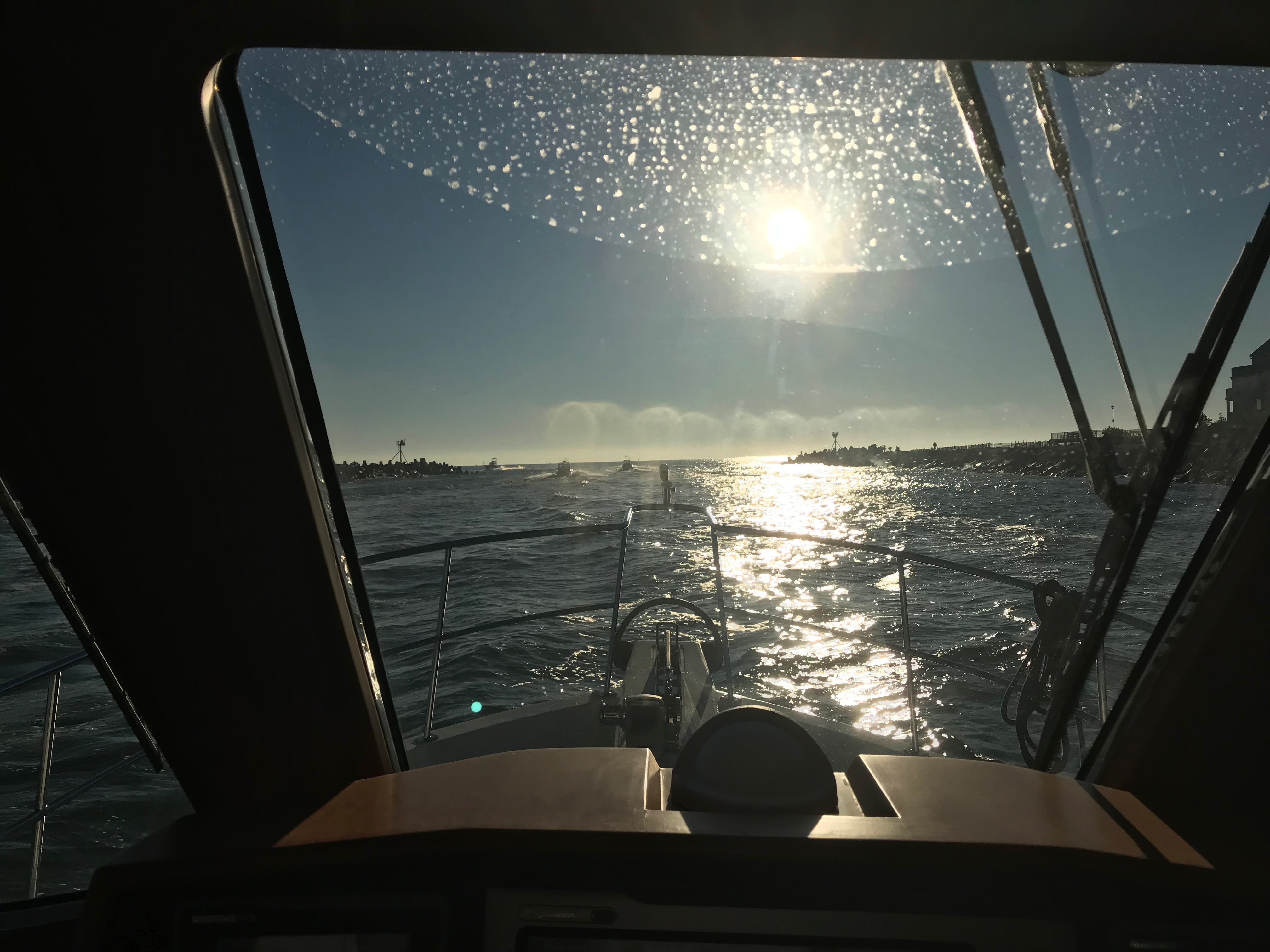
View from the Pilothouse
Sunset in AC
We were just feet from the Golden Nugget Casino.
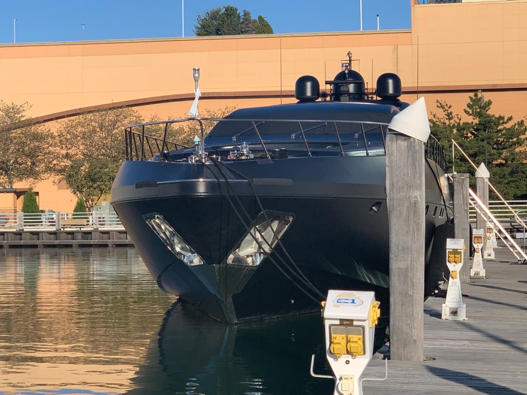
MV Neoprene docked in front of the Golden Nugget
MV Neoprene is a like a fart in the shower… it just can’t be ignored.
Stern
Port Side
Bow
MV Neoprene
Gambling is not our thing but we would not miss out on hitting the casino. Even if trying to enter the casino felt like we were in Alfred Hitcock’s “The Birds”.
The Birds
In went us…
We played some blackjack and the slots for a bit before loosing enough money to feel like gamblers.
One Armed Bandit
Pro Gamblers
Golden Nugget
Time to hit the Chart House for a good steak. Our table overlooked the docks and you could see the cobalt blue lights of MV Simple Life through the window.
Chart House Restaurant
View from our Table
Simple Life out the Window
This leg of our journey looked something like this..
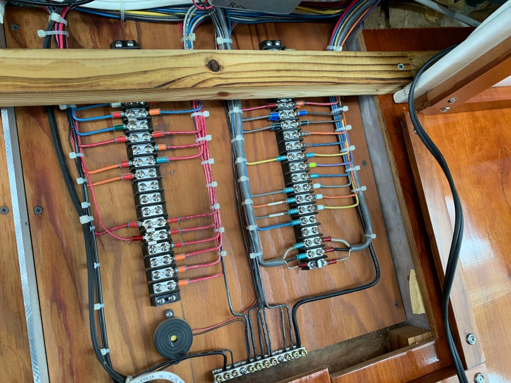
The repair of the radar turned into the install of a radome a wind transducer and a second MFD (Multi-Function Display ie. Chartplotter). This required several electric kick-scooter trips to West Marine for miscellaneous switches, cables, etc. We had to pull the inside roof of the pilothouse down in order to snake cables between the two helms (Pilothouse & Flyberidge). This took several days.
PH Wiring
Flybrridge Break Out Panel
We met our neighbors Capt. John and Charlie who were bringing a 55′ Sunseeker Manhattan to Florida. If you are interested it’s for sale on YW (YachtWorld.com). $2.25M
2021 Sunseeker Manhattan 55 For Sale
Capt John was very knowledgable about boating technology and we discussed everything from LiPO4 batteries & BMS (Battery Management Systems) to Chinese diesel fired heaters. Capt. John had many projects going on with his own one-off sailing yacht called Myth.
SV Myth
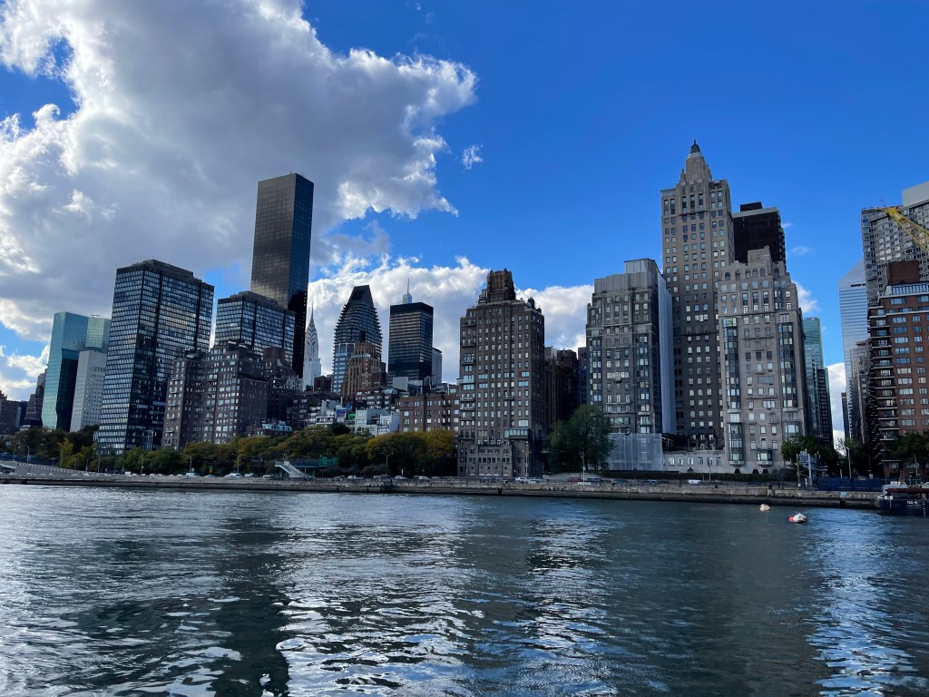
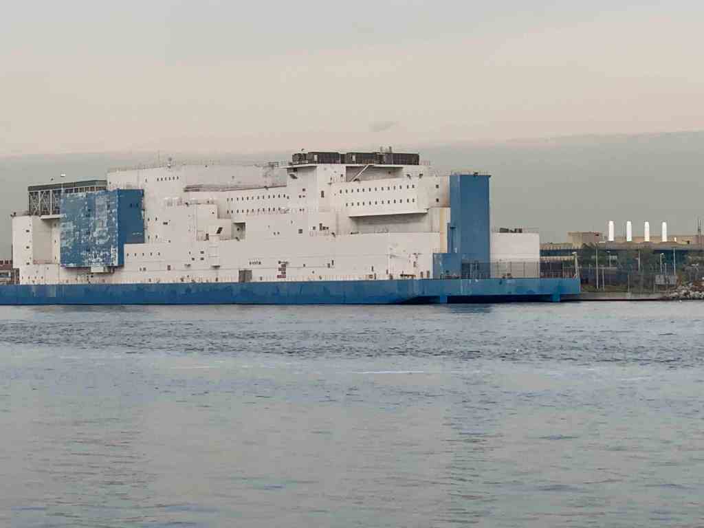
We got a late start but it felt good to be moving again. We slipped past a lonely lighthouse before entering the East River. Soon we were passing the massive prison ship in the Bronx. Vernon C. Bain Correctional Center (VCBC)
Prison Ship
The clouds looked like cotton balls as we cruised West down the East River.
Lady Liberty always reminds me freedom is what everyone wants in this world.
Our Lady Liberty
Freedom
As we scooted beneath the Verrazzano Bridge we passed a large container ship entering NYC harbor.
Cargo Ship
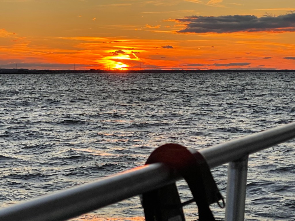
As the day came to an end we decided to drop the hook behind Sandy Hook, NJ for the night. As the sun disappeared beneath the horizon we tucked in for the night.
When my youngest sister, Janet & I were acting bad, our Dad would simply state “Who wants a wallop?” My first thought was “What’s a wallop?” Later I learned… It was code for you better starting acting right or Dad’s gonna straighten you out like a piece of wire. Lucky for us, it was rare he ever had to make good on that threat because we knew enough to stop.
You may be thinking… why is he talking about about getting a wallop? Well… ADD aaannnd tonight’s anchorage will be Wallop’s Island. There are not many places to anchor along Virginia’s Atlantic coast but this is one of the few.
Wallop’s Island along Virginia’s Atlantic Coast
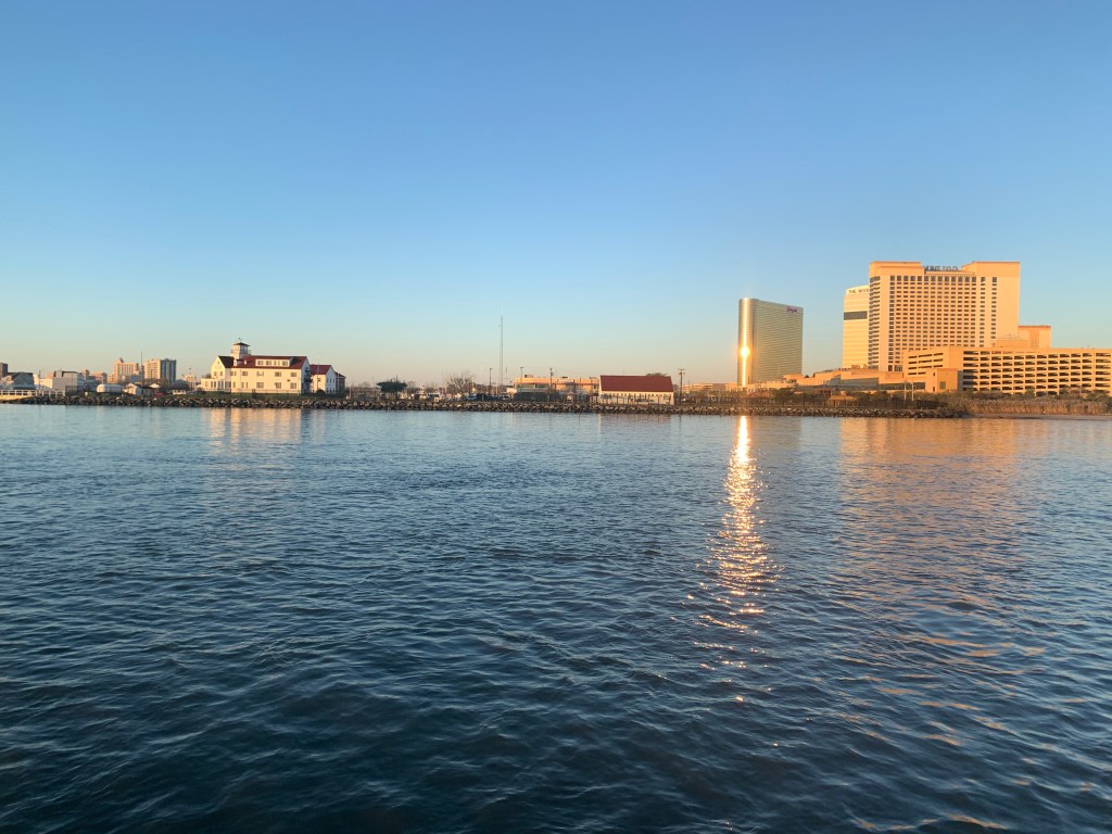
Absecon Inlet
I only slept for 2 hours and awoke at first light. It’s amazing how refreshed you feel even after as little as 2 hours sleep. As I look out the pilothouse windows I can see a bright spot of sun on the metal exterior of the 430′ high Borgata Hotel Casino & Spa.
Borgata Hotel Casino & Spa
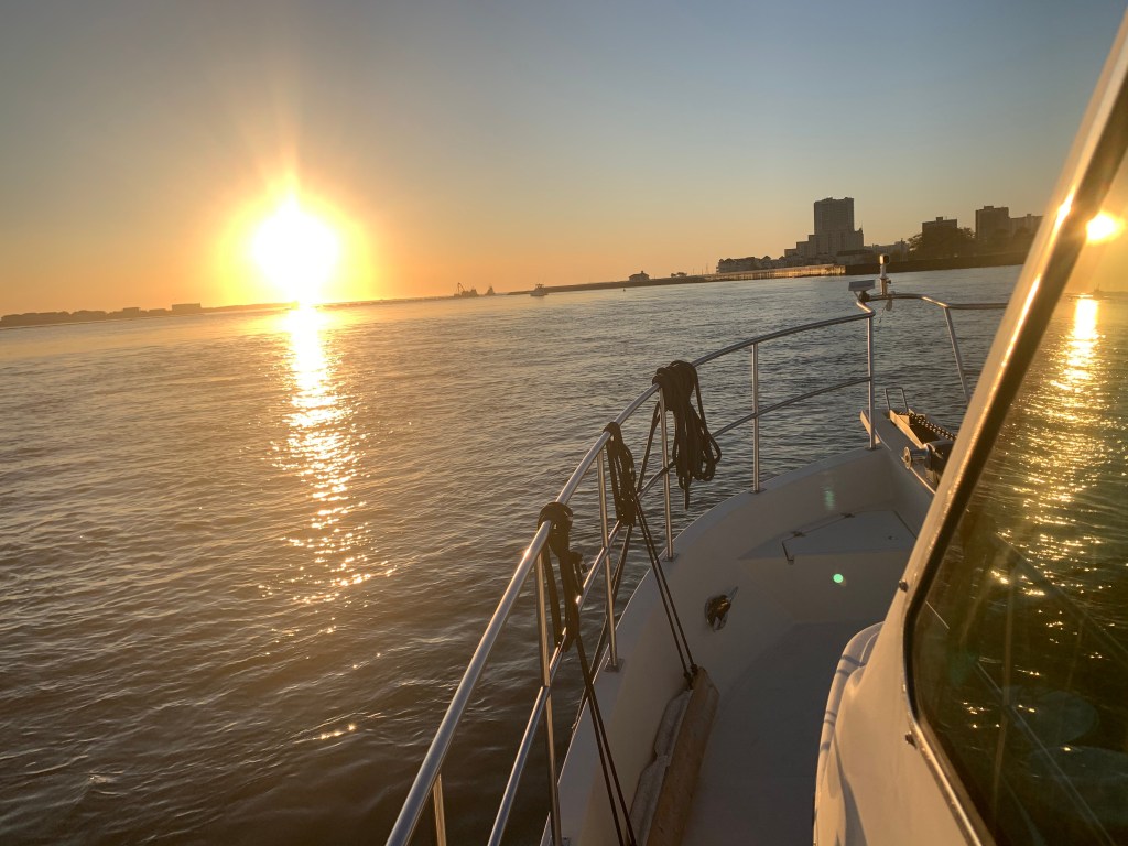
As I glance out the other side of the boat I see Ra, the ancient Egyptian sun god, has just started his journey across the cloudless sky.
Ra’s Journey Has Begun
I am not alone. Last night I weaved through three sailboats to find an empty spot to drop my anchor. I wonder if they will even know I was here?
We are not Alone
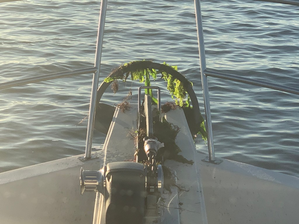
When I finally retrieve my anchor into it’s bow roller I see that it’s covered with sea lettuce. Well I’m sure there is a more technical term but I’m sure the strong current was trapping the lettuce against my anchor chain like lettuce blowing in the wind.
Fresh Salad aboard MV Simple Life
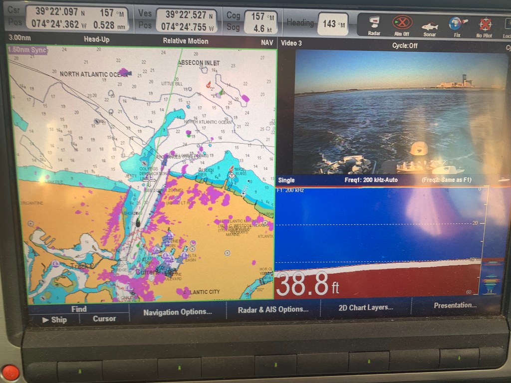
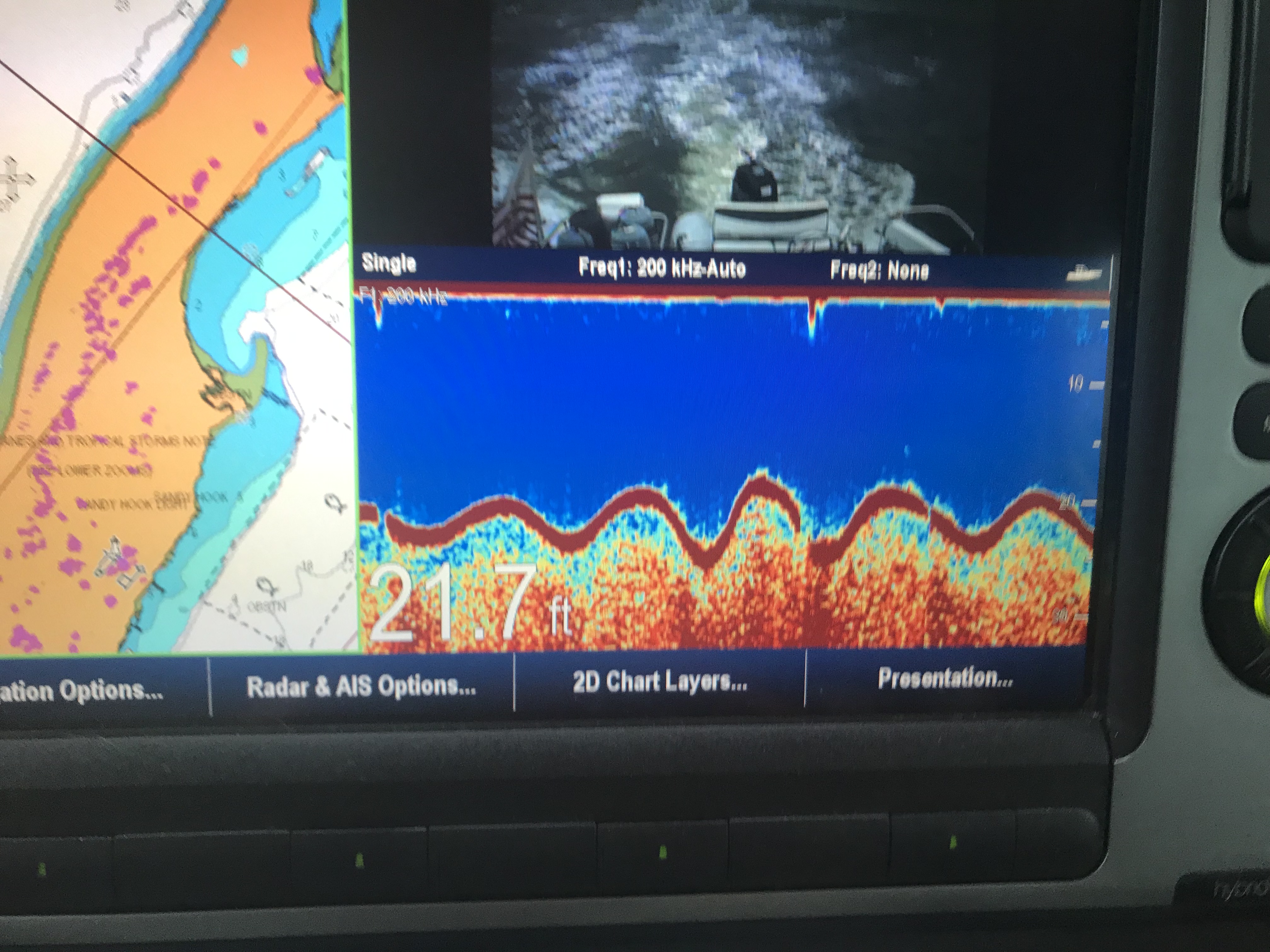
As I look in my review camera I am reminded of how deep Absecon Inlet is.
Almost 40′ deep inside Absecon Inlet
As deep as it is inside the inlet there is quite a bit of shoaling going on around it’s entrance. The Aqua Maps chart plotter view below shows a few of my past tracks entering and leaving Absecon Inlet. The pink track entering from the left of the picture was my track coming in at 3:11AM on 11/4/20. While the charts show depths like 20′ and 15′, reality was much closer to 9′ as I came across that shoal. Whenever you are navigating inlets your chart depths are not to be trusted. If you have any ocean swell action going on you’ll often see breakers wherever the shoals exist.
Brigantine Bay anchorage on left, Absecon anchorage in middle and Farley State Marina on the right
As I make my way out of the inlet I am bucking the incoming tide and it slows my normal 6.5 kt speed down to a plodding 4.6kts.
Fighting Absecon Inlet Current
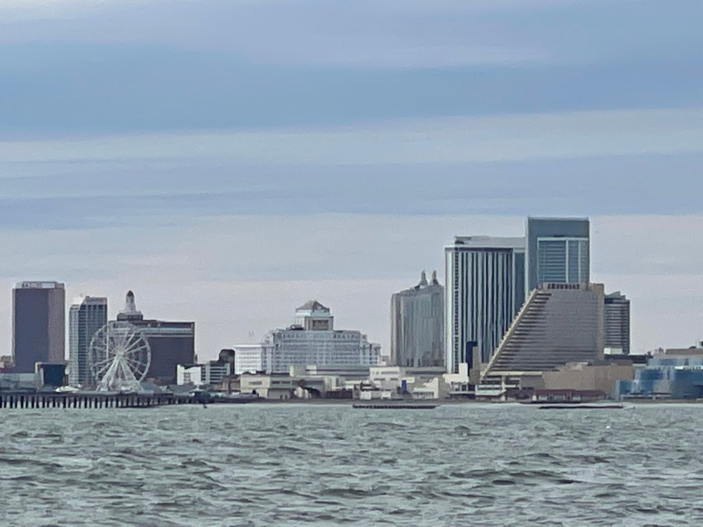
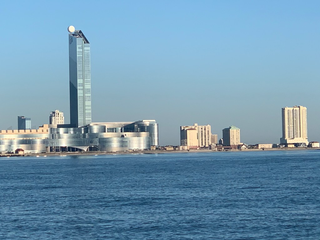
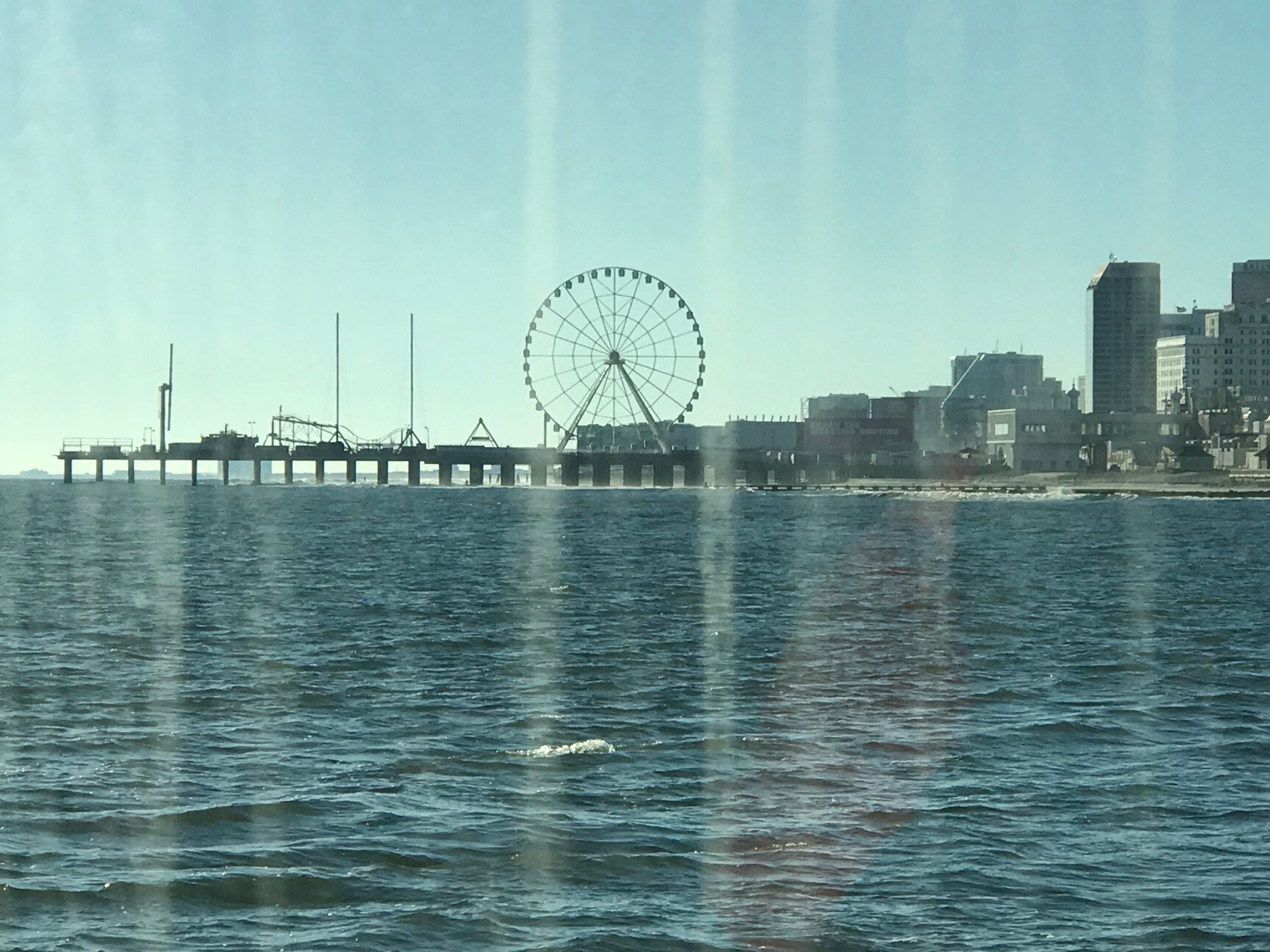
Atlantic City Architecture
As I leave Atlantic City I look back at both the 710′ high Ocean Casino Resort and The Wheel @ Steel Pier (227′ high). Both of these object are lit up at night and can be seen for miles as you approach on a dark night. The ball at the top of the Ocean Casino Resort (The former Revel Casino Hotel) glows with changing colors.
Ocean Casino ResortThe WheelA glowing Wheel
Digital Selective Calling
The next hours many hours were spent cruising the coast with hardly a boat to be found. Then suddenly the VHF radio sprang to life.
Me ACK’ing a DSC distress message with no LAT/LON or nature of distress info in the message
VHF radios have evolved to use DSC or Digital Selective Calling which allows for making calls to select individuals or groups using their MMSI number (Maritime Mobile Service Identity). DSC also allows for making a digital distress call like the one I received. After ACK’ing the call I received, I immediately entered the boat’s MMSI number and called them back directly. No response! I tried several times for about 30 minutes while I scanned the horizon with my binoculars for any signs of boats or activity. Nothing. Other boaters have told me stories about how the distress button gets accidentally pushed on radios and when someone calls back the people won’t answer your call. Often after you accidentally push the distress button, many boaters attempt to call you back and having to repeatedly tell each of them that you accidentally pushed the button can be a humiliating experience.
Learn From My Mistakes
All that said… I still wish I had notified the USCG.
At the time I thought… there was no location or nature of distress information included in the DSC message. So I would simply be telling them that I received a message with no other info. BTW, the location information is probably one of the greatest reasons for DSC distress in the first place. You simply hookup a NMEA (National Marine Electronics Association) data wire from your Chartplotter/GPS to your VHF and the VHF automatically sends your LAT & LON coordinates as part of the digital distress message. Had the location info been sent I could have gone to the location given.
Even though I know…
Buttons get pushed by accident
I could see no boats or activity
Whomever pushed the button never answered my reply
I realize it was a mistake not to inform the Coast Guard that I received a message. Next time, I will be prepared on how to handle this situation. Boating is a learning experience. I make mistakes and I learn everyday.
Night Approaches
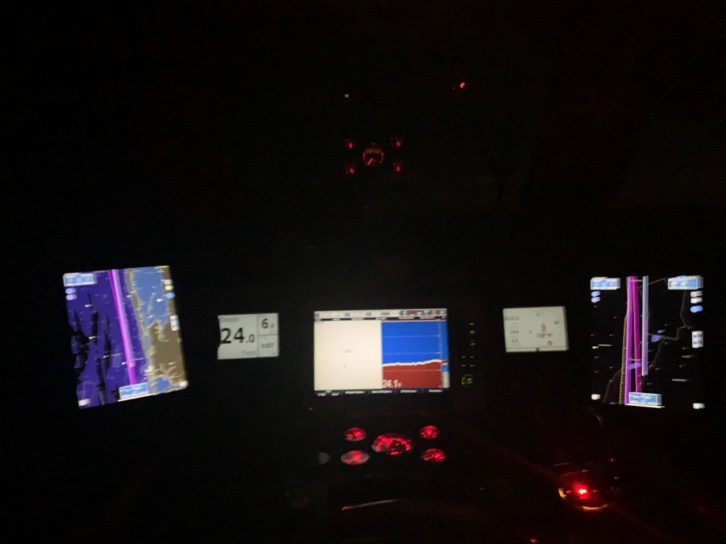
The sun was setting. I settled back into my captain’s chair and prepared for dark. There was a half moon tonight but moonrise would not occur until around 8PM. I let the flybridge lights so that I would be seen by others and between radar and occasionally spotlighting I felt good as I cruised on into the night.
Tonight’s sunset behind Fenwick Island near Ocean City, MD
I adjusted the brightness of my chart plotter & instruments as well as set dark mode on my iPads. Nothing can be seen outside but the reflection of my instruments in the pilothouse windows.
I arrived at Wallop’s Island around midnight. It was a long 17 hours at the helm. I’ll be up at first light but I’m sure I won’t have any issues getting to sleep tonight!
Winter 2020 – 115NM Leg 004 looked something like this…
I purposely got a late departure from the marina in Port Washington because I wanted to catch a fair current. When I went to leave my slip the gale force winds were on my beam. When you are solo you must untie and leave only a front a back looped over the cleat so you can climb aboard and flick the lines off and go. The problem this morning was that after I flicked off the stern line and ran through the boat to get to the bow line I’m sure the boat would be sideways in the slip. I opted to tie the boat with a single line, jump aboard, flick the line of the cleat and try to get out of of my slip before the wind had it’s way with me. Lucky for me the slips are very wide as were the fairways.
Pulling out of Port Washington a sailboat was following me.
Blue-hulled sailboat reminds me of my old Hunter sailboat before I bought my trawler
Port Washington is just around the corner from the east end of the East River.
Port Washington is a great staging location to wait for a fair current
Under Bridges
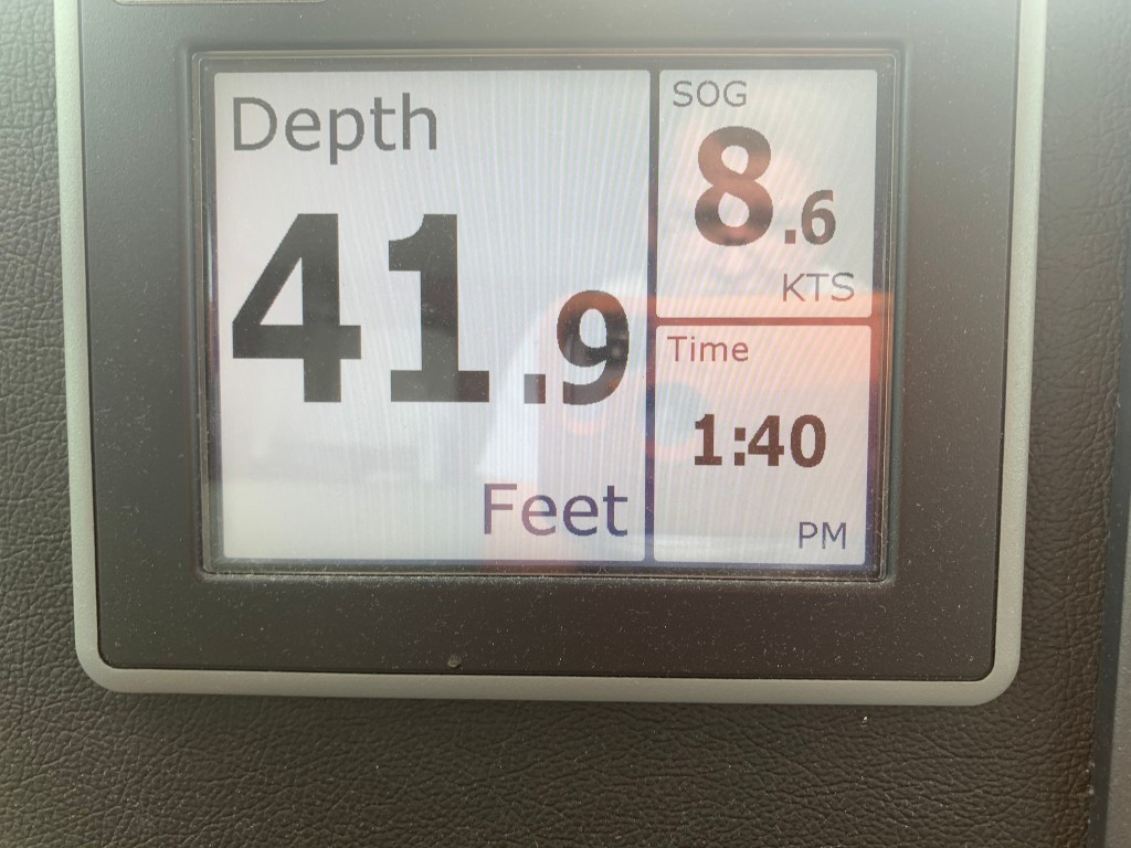
Throgs Neck Bridge is the first bridge as you enter the E. River. You can see the Bronx – Whitstone bridge behind it. The fair current boosts my speed from 6.5kts to 8.6kts as I zip along under the bridge.
Throgs Neck Bridge East end of the E. River8.6 kts thanks to the current
Passing Traffic
Almost immediately I’m being passed by USCG & NYPD boats as well as other boat traffic. They are everywhere as you navigate the East River.
Dystopia
The NYC skyline can be seen in the distance. On this cold grey day I can help but think it looks like a scene from some dystopian future SciFi flick.
Dystopian future skyline
Push Me Along
As I approach the infamous Hell’s Gate where the E. river & Harlem river converge my speed jumps to 11kts.
work pajamas on feet in the helm
Right of Way
Soon I had an oncoming boat that was crossing my port bow. They were on a collision course so I sounded my airhorn for a 1 whistle pass. They did not change speed or direction. I blew my horn again and again with no reaction from the oncoming boat. I finally laid on the horn turned to starboard. We exchange some hand waving before the captain got on the VHF calling me a moron. I simply explained that he did not have the right of way. He was on a collision course. He did not respond to my sound signal and left me no choice but to stop. No response.
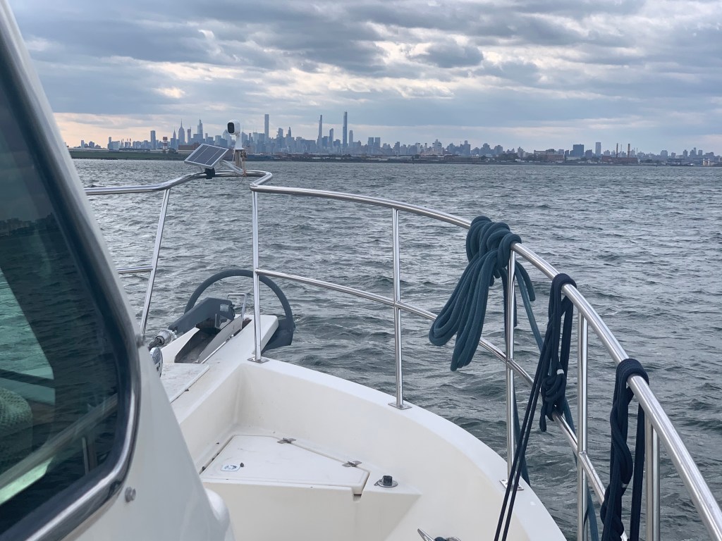
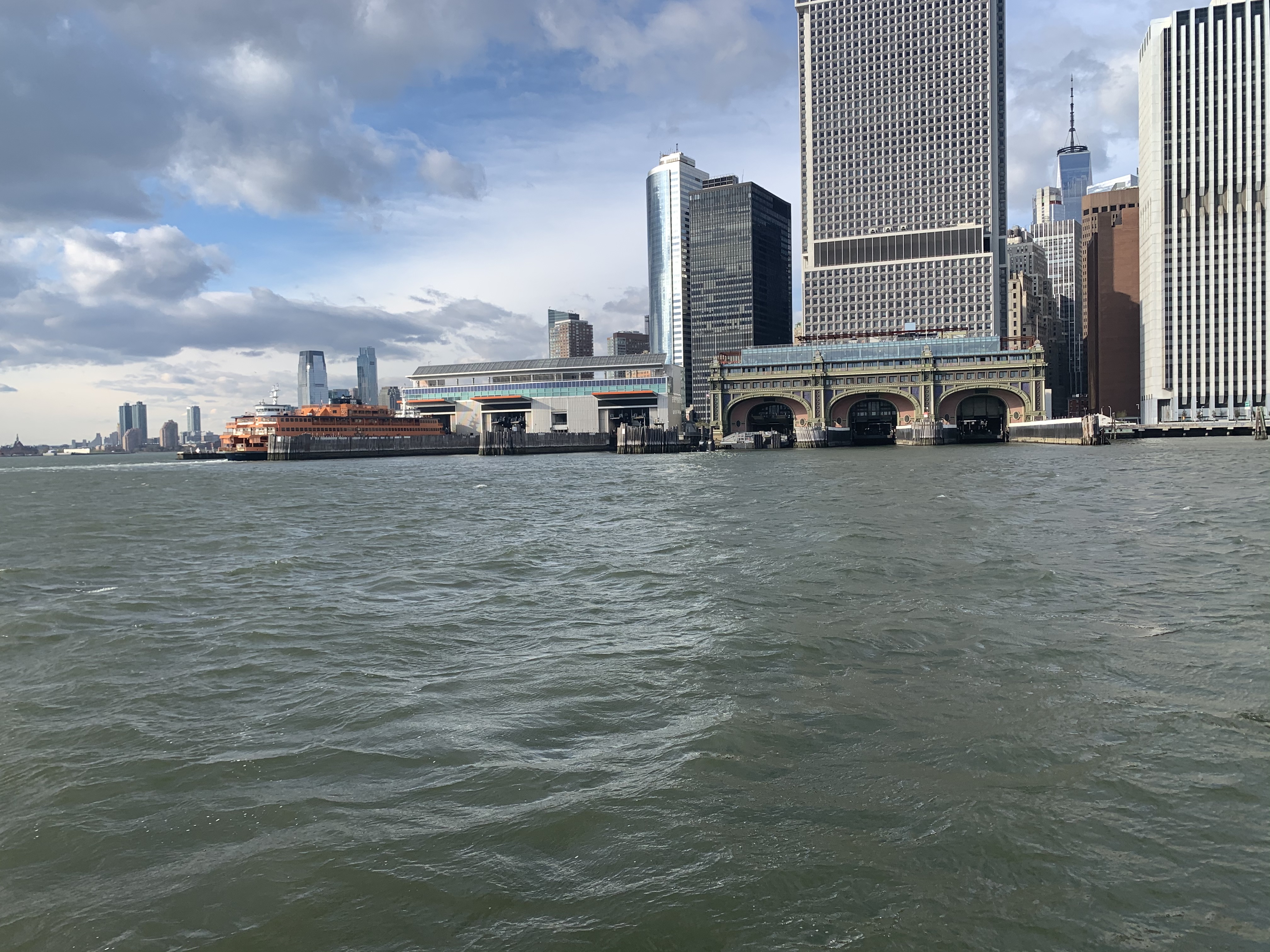
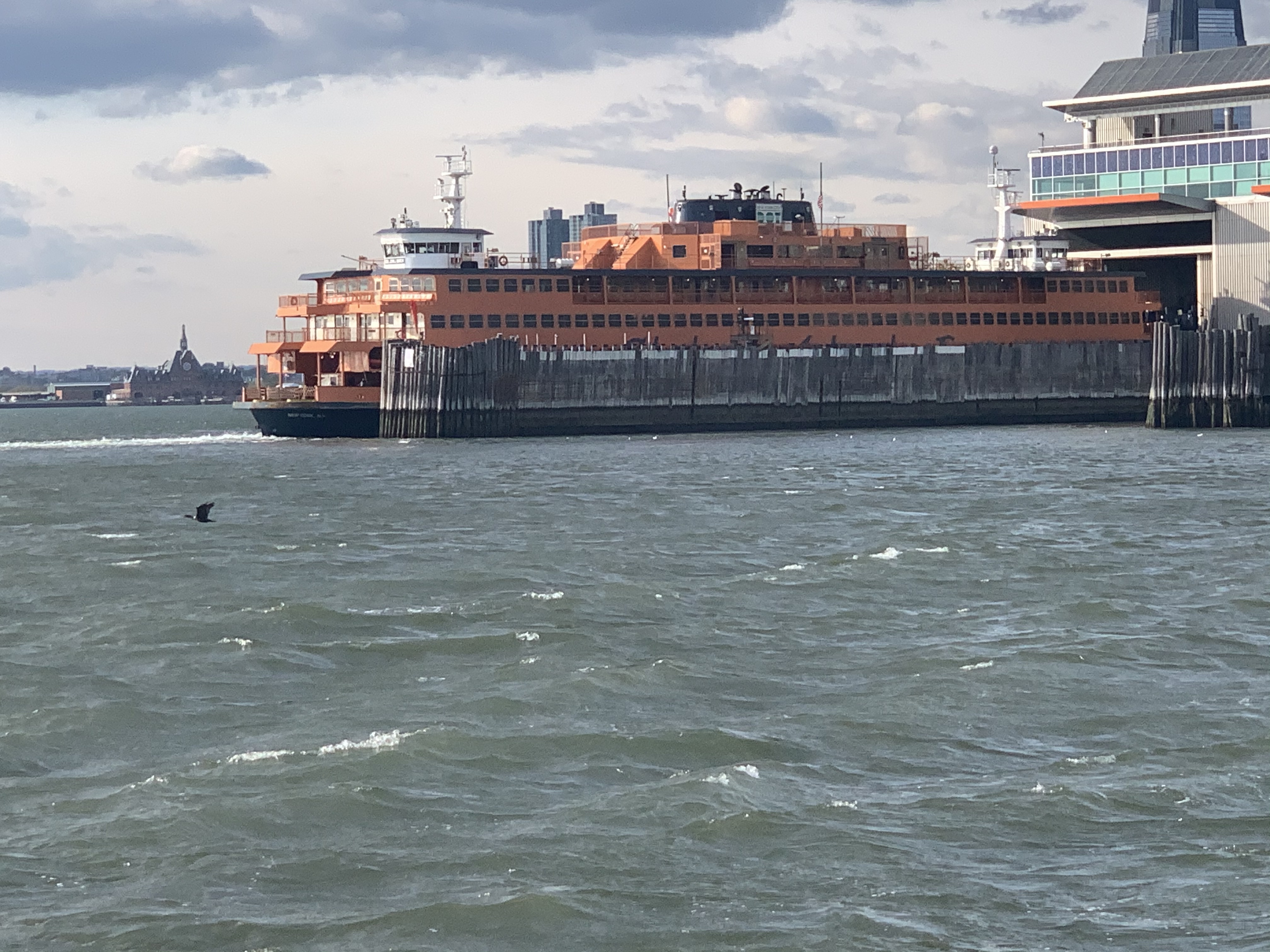
Staten Island Ferry
As I pass the souther tip of Manhattan I see the ferry terminal and the Staten Island ferry docked.
They never stay docked very long. NYC’s fast pace as passengers rushing off and on and they are underway again passing me.
A Sexy Girl goes Past
As I’m passing the Statue of Liberty I see a radar return for something passing me on my starboard side. She’s a beauty. MV Arriva from England.
Hustle and Bustle of NYC
This is the busy part of NYC harbor and all sorts of traffic is passing me.
USACE (US Army Corp of Engineers)
Maersk Containership entering NYC harbor
The Jersey Shore
As I pass under the Verrazanno Bridge and past Sandy Hook the sun is setting and at first it’s a beautiful yellowish orange.
Yellowish, orange sunset off Sandy Hook
But minutes later it’s very pink
Pink sunset off Sandy Hook
Serenity
My AIS shows a 66′ foot yacht approaching from my stern.
AIS info transmitted between boats digitally over VHF CH#70
hmmm… 33 feet of beam I think as I wait to snap a photo of this boat with the sunset above. MV Serenity VII is a Lagoon 63 – 4 cabin, crewed power catamaran for charter. You can reserve it here for about 30K/week in the Bahamas if you like? I’d guess the crew are bringing the boat south to the Bahamas for the start of the chartering season.
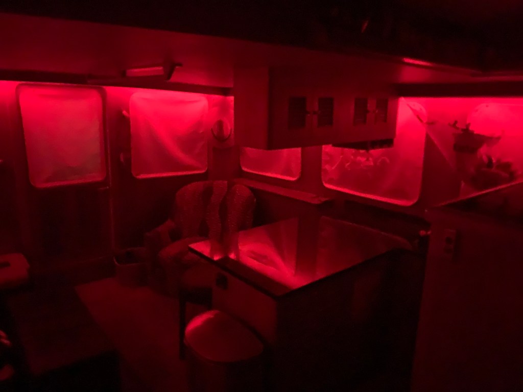
Red Light District
As the sun sets I swap my salon LED lighting from blue over to red to keep my night vision.
The rest of the trip was a long dark ride to Atlantic City. The sea was calm and I was scheduled to arrive around 4AM. This leg of the journey was 16 hours. I had planned to anchor in Brigantine Bay but it was dead low tide when I arrived and every attempt at getting in the narrow entrance channel ended with the bow slowly riding up on a muddy silty shoal. Being as tired as I was, I simply found a place to drop the hook near the Golden Nugget. The anchor was no sooner set and I curled up on the pilothouse berth and was sound asleep. I plan to wake in 2 hours when the sun comes up and as I have another long 100+ NM day.
W04L003
The 113NM third leg of my Winter 2020 journey looked something like this.
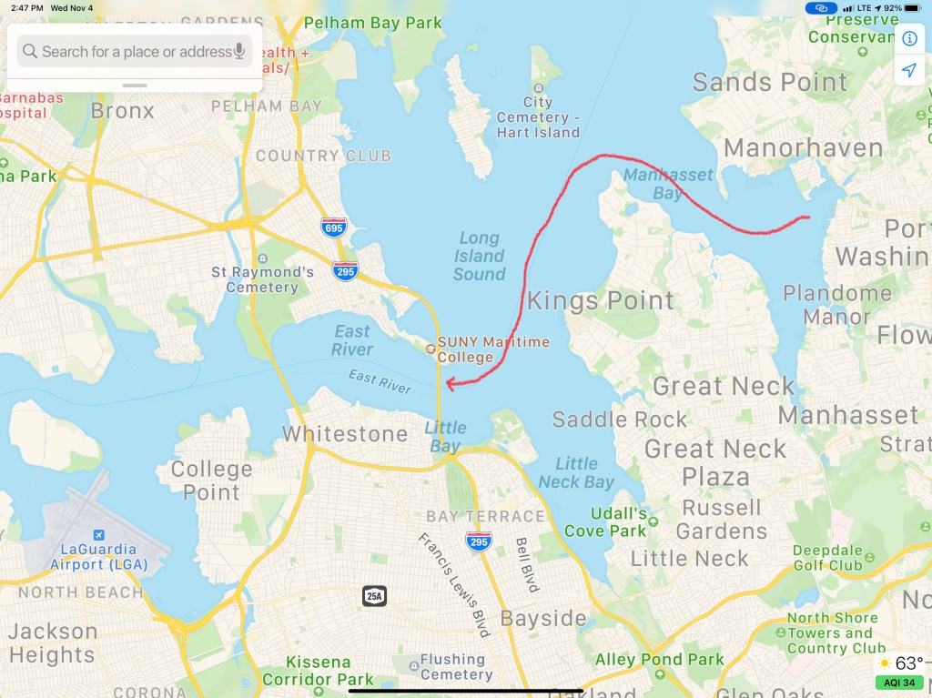
We departed Port Washington and perfectly timed our arrival to the east end of the East River. We had a fair current giving us a strong push on our stern all the way through the East River and into NYC Harbor.
East River
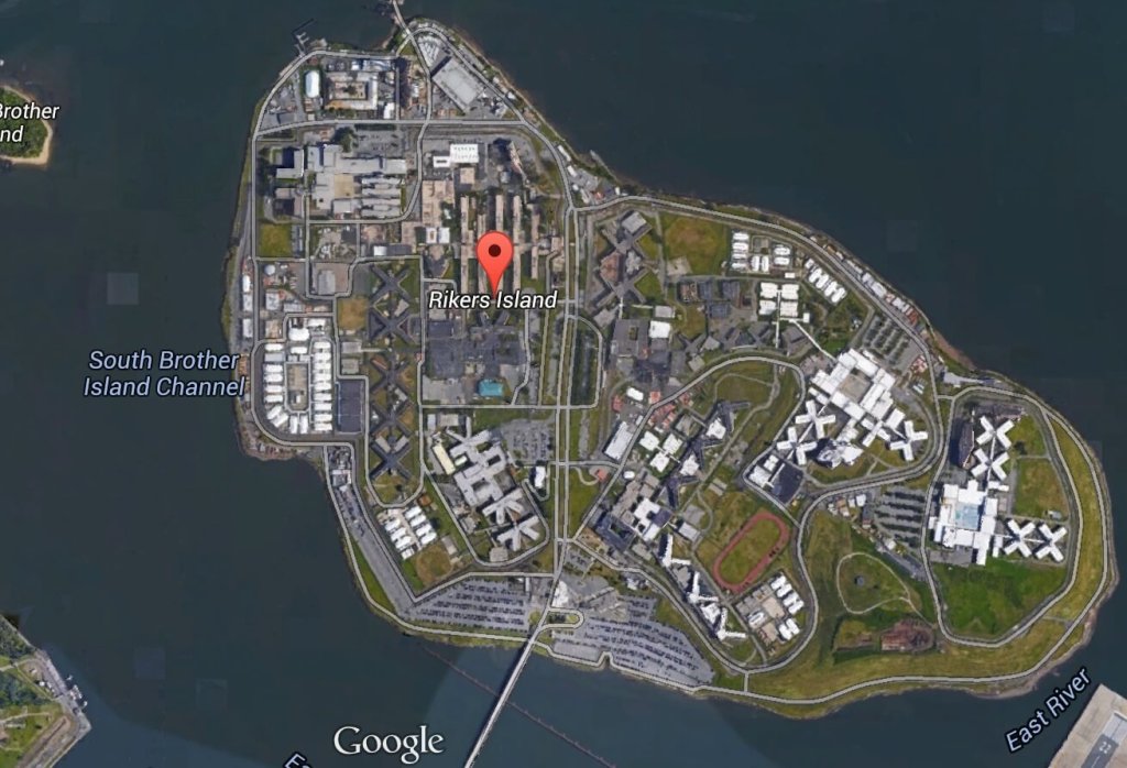
Once in the East River you come upon Laguardia airport and Rikers Island.
A wee bit further down the East River and you come to an infamous location known as Hell’s Gate. This is where the Harlem River dumps into the East River. Our planning placed us here at max ebb current because it’s a great feeling being pushed in such a strong current.
Buddy was at the helm calmly making helm corrections as quickly as possible to keep the pointy end of the boat pointing in the right direction.
We had planned on spending a couple days in NYC harbor and visiting Manhattan but our weather heading down the NJ coast looked great for the next 38 hours. We had a quick discussion at the helm and decided that we would go offshore. Stopping in NYC would have meant being trapped for the foreseeable forecast.
Sunday 4-6′ Seas
Need to be South of NYC by Sunday
Offshore Voyage to Norfolk, VA
Going offshore to Norfolk would require a helm watch schedule. We like to call it a port & starboard watch meaning that there would be two teams. Team 1 = Buddy & Renee. Team 2 = Marty. When you’re on “helm watch” the other team is relieved of any responsibilities other than to rest up for when your watch starts.
Night watches means keeping an eye out the pilothouse windows for any lights. The moons phase was only a sliver of a crescent and it did not rise till 4AM. We chose a route between 2-3 NM off the coast and that allowed us to see the twinkling lights of shore as we made way south.
For those uninitiated in night watches you will have to become comfortable with staring intently at your radar screen while you push into the blackness. Looking forward out the pilothouse windows all you see is black and the few instrument lights that reflect off the inside of the glass. You’ll need to determine if any of those red, green or white lights are coming from a boat or a buoy. If the light blinks, it’s a buoy. If it’s solid, it’s a boat.
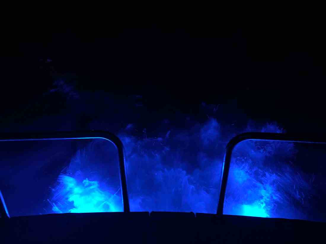
One night I come off watch and lit the underwater lights so I could stand on the stern as the propeller wash boils up from below as the lights of shore pass.
Here is a short video of a boat passing on our starboard side. You can clearly see the other vessel’s red-portside-light as well as it’s white-steaming light. When I zoom in the camera was able to pickup the white water wake in their stern light.
When I left my home port in Warwick, RI, a few fellow boaters, friends were also making the trip south for the winter. MV Ship Happens, a large sport-fishing boat, was heading south and we had been communicating thinking we’d cross paths eventually. I received a photo via text from Capt. Dan and to my surprise it was of MV Simple Life as they zoomed past us. Although MV Ship Happens left port days after us, she has a much faster cruise and eventually overtook us.
Capt. Dan snapped this pic of us on the way past us
During the day we were graced with the presence of whales. I captured a short video of a whale coming to the surface off our starboard side.
Whales off the Jersey Coast
While we were off the coast, our VHF crackled to life with the USCG issuing a securite broadcast about an overdue 43′ Benneteau sailing vessel out of Jamestown, RI called the “Carol K”. They had left before us and were somewhere along the coast with us. We attempted to hail the Carol K but got no response. We hoped that they would be found safe and several days later they were found 100 miles of Cape Henry, VA.
The trip down the busy channel into Norfolk, VA is best done in the daylight. I could tell you a story about nearly getting run over by a warship a few years back but that story is best told over a few beers. 😉
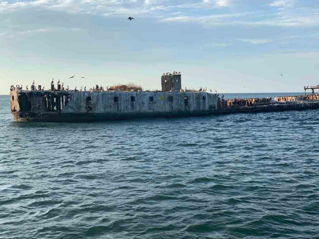
We searched our Aqua Maps charting app for an Active Captain anchorage and found one called “Concrete Ships”. The wind was out of the east but the forecast predicted the wind would clock around to the south and strengthen. This particular anchorage offered the best lee from the wind within the distance we were willing to travel.
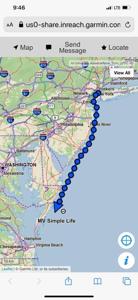
My website/blog has a button that you can click to see the real-time location of MV Simple Life. Here are some pics of that my Garmin InReach Satellite communications device makes available to you.
Working our way down the East Coast
Arriving at the Concrete Ships Anchorage
Days past, I have made the trip south from Cape May, NJ to Norfolk, VA by going outside along the coast before. Those times, I had chosen to anchor nightly along the coast. There are few decent anchorages along this stretch of coast. One anchorage I have used before was inside the Great Machipongo Inlet. I recall how tricky getting through the shifting shoals dotting the inlet was. As we passed, I could not help but notice that the latest update of the NOAA charts shows a similar sized vessel to MV Simple Life wrecked on those same shoals. (Me thinks…) I’m happy I bailed on my inlet entry that stormy night.
Ghost Ships
When it comes to ship building there are many hull materials to select from. One such material/method is ferrocement construction. It’s a cheap way to build a hull/boat but has fallen out of favor with the advent of materials such as FRP (Fiberglass Reinforced Plastic).
We had arrived at our anchorage with plenty daylight left. We shot some video and snapped a few pics of the ships as we arrived.
Standing on the bow at night in the breeze we were flanked by ghost ships with their ghostly pale white shapes faintly materializing though the inky black of night.
Well exited the Manasquan River right at slack tide which is good for reducing the currents when trying to squeeze through the narrow railroad bridge as well as the rip at the mouth of the inlet.
Manasquan Inlet Slack in 7 minutes
NJ ICW Mile 0
As we headed out the Manasquan River we looked back and saw Point Pleasant canal which is mile 0 or the start of the NJ ICW (InterCoastal Waterway).The NJ ICW ends in the Cape May entrance channel.
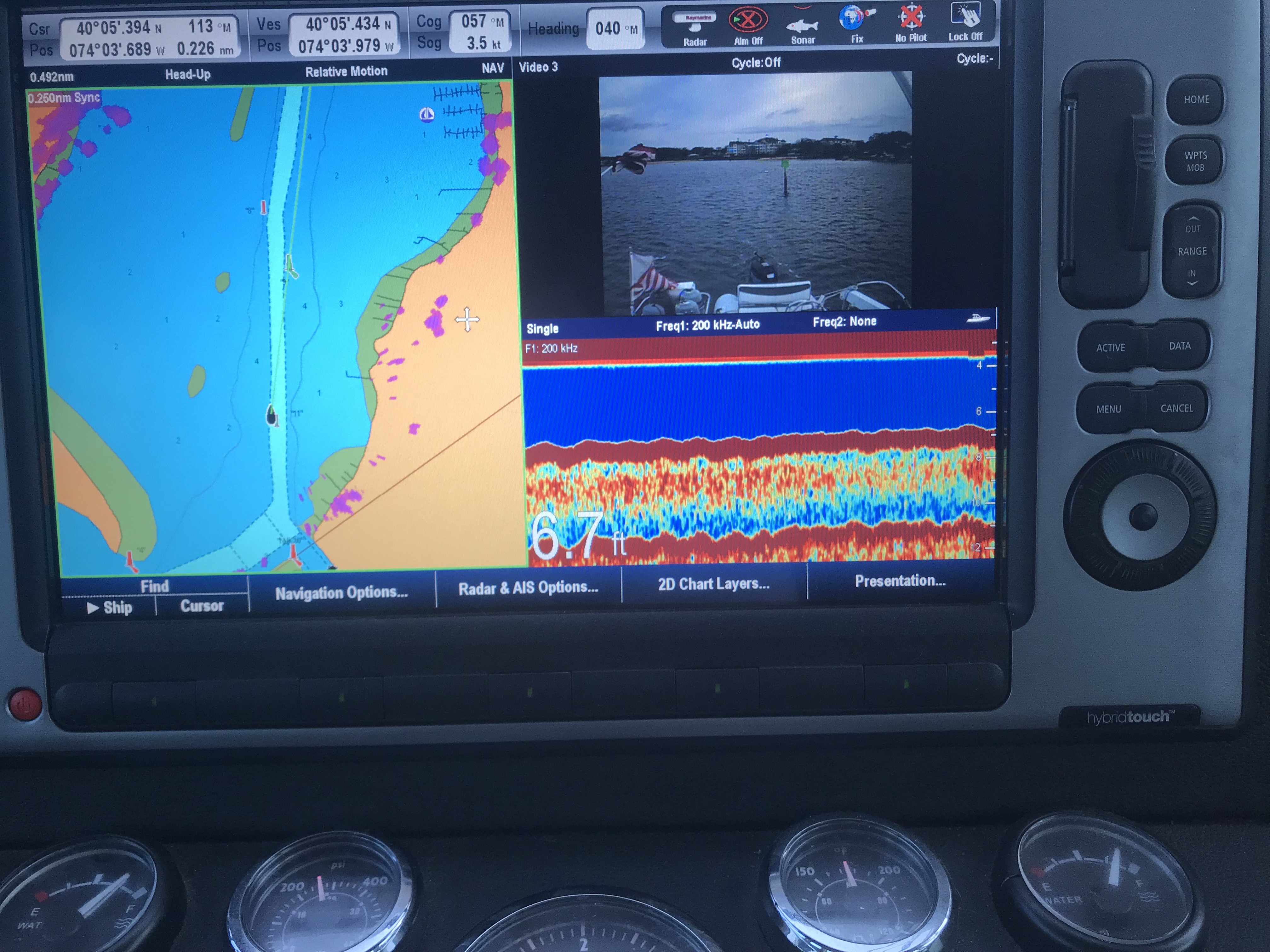
Notice the 6.7′ depth
As you work your way out of the Manasquan River be careful. My charts don’t line up perfectly with the channel’s actual location so follow the daymarks and temporary buoys and cans that are in place.
There are two bridges on Rte. 35 and the other is an automated railway bridge.
Approaching Rte 35 Bridge
The Rte 35 bridge gets shallow just as you are about to pass under it. So when your low water alarm goes off don’t break your focus and stay straight going through.
6.6′ depth just as I’m passing under it.
Normally open Railway Bridge. I heard the opening is only 48′
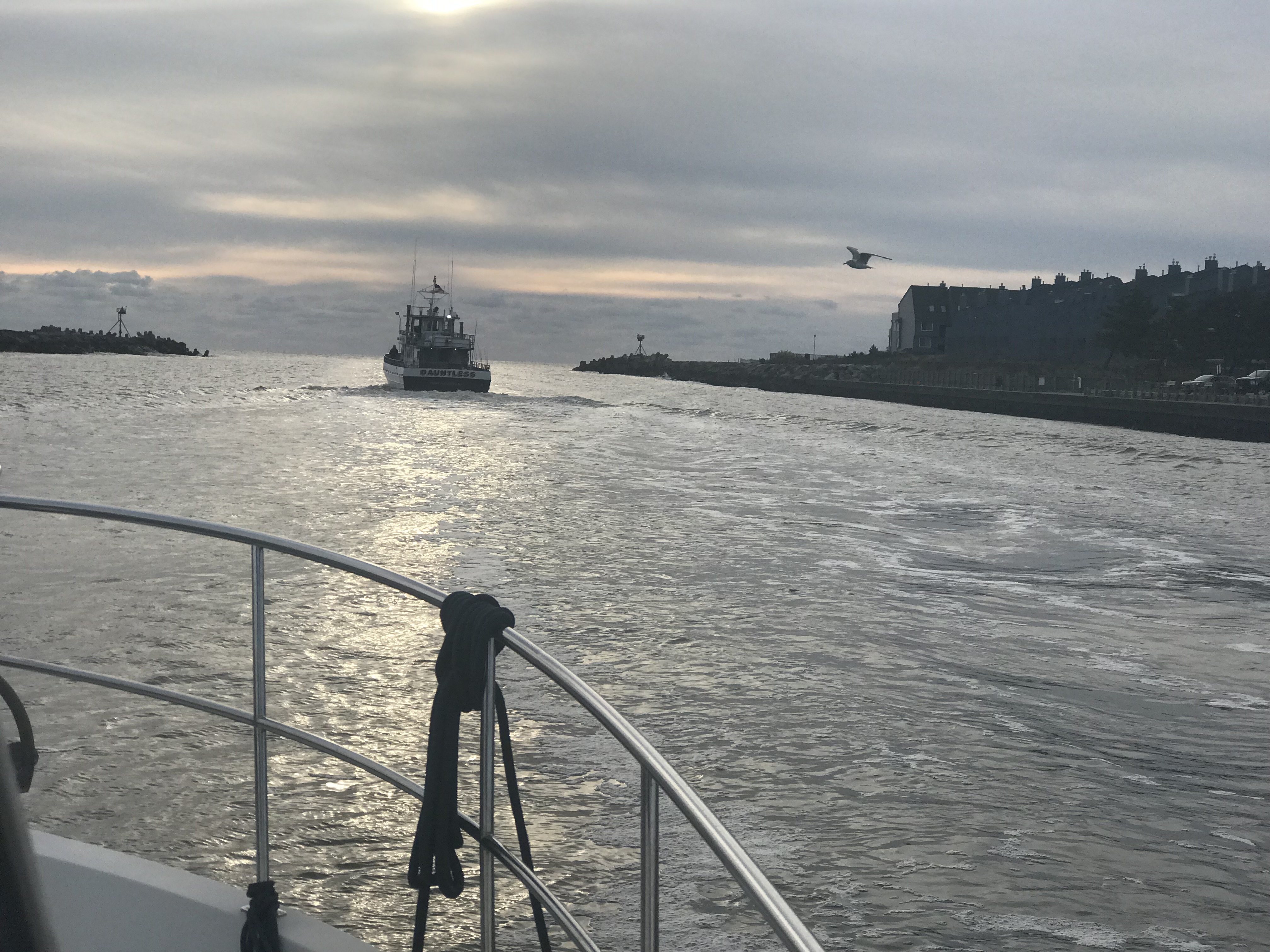
Soon we were at the inlet to the Manasquan River and we exited into the Atlantic.
Manasquan River Inlet – Leaving
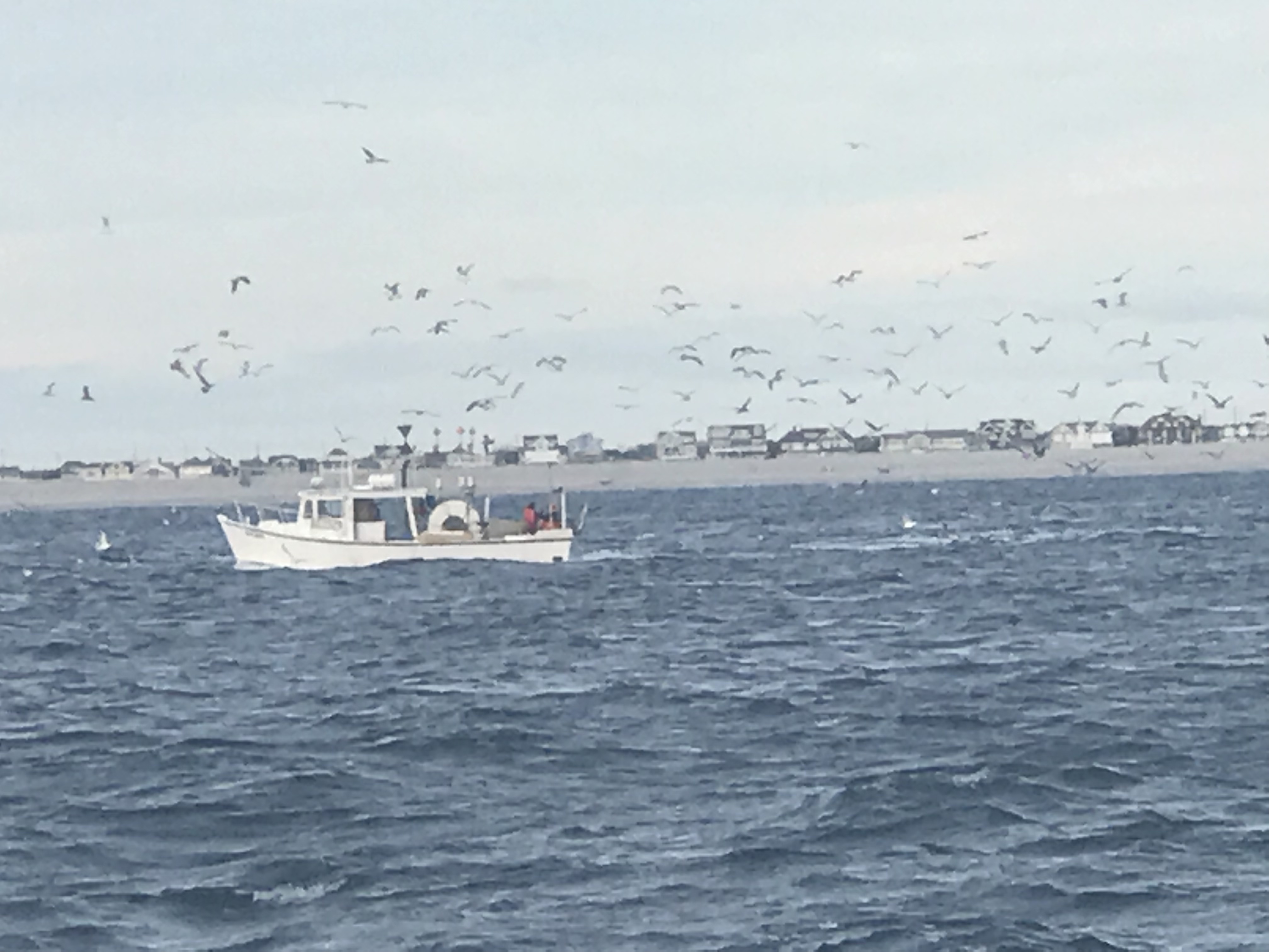
There were not many boats out on the NJ coast. It is mid-November after all.
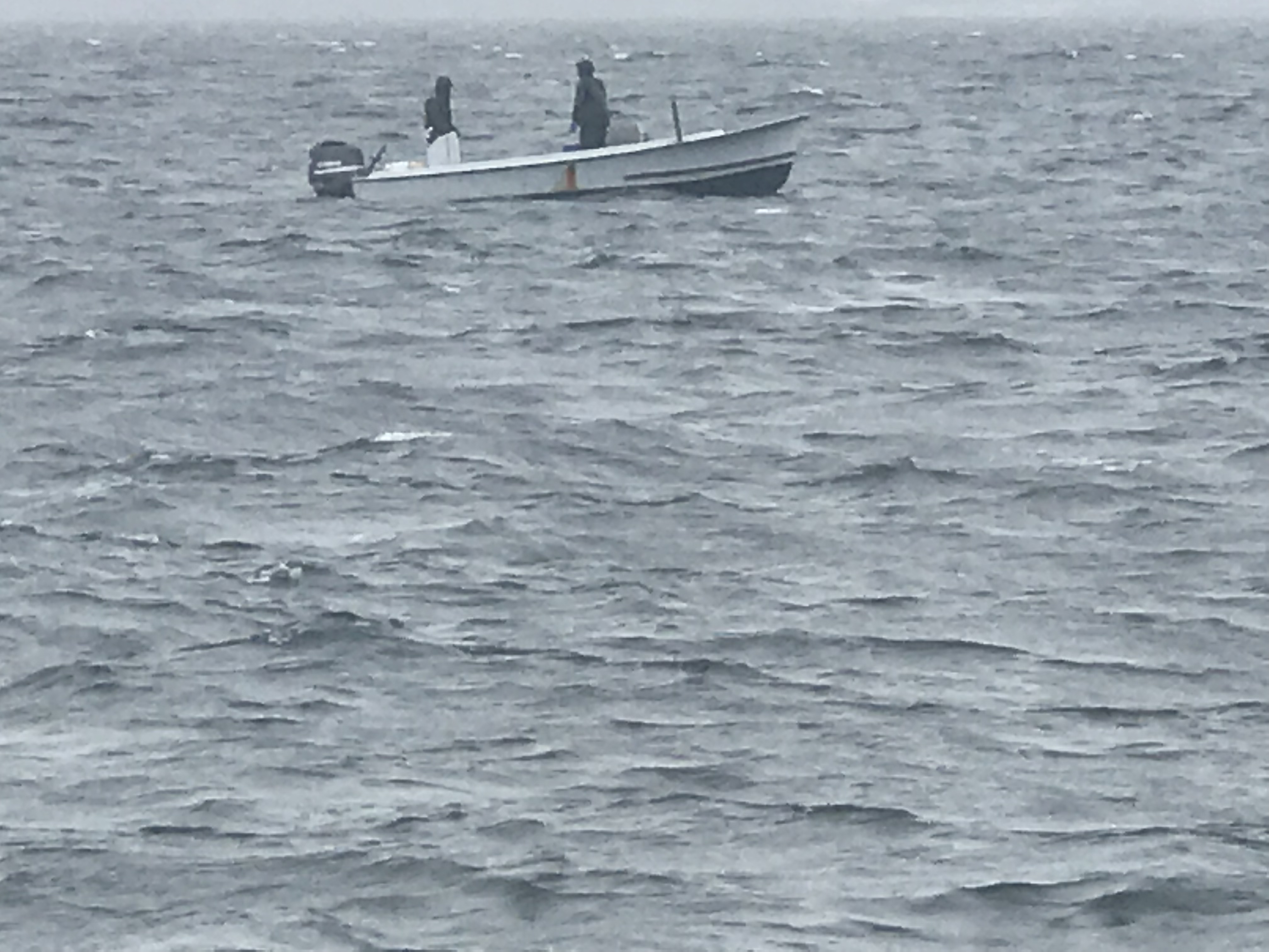
However this FV (Fishing Vessel) Webo looked like a scene from Alfred Hitchcock’s “The Birds”. Soon I found him piloting real close up the back MV Simple Life and I swear he did it to infect us with his flock of sea birds. As he pulled away the flock split and half seemed to follow us. Kelly’s not a real fan of birds something about getting caught in her hair or something … so I just did not let her know that the birds were surrounding us.
Bird Boat
FV Webo is not 70′ long!
FV Wevo on our backup cam
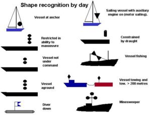
Note the double black cones day shape to designate a vessel engaged in fishing
I could not help but notice that FV Wevo was using dayshapes to let other boaters know he was engaged in fishing. Two black cones, point to point in a vertical lines designates this.
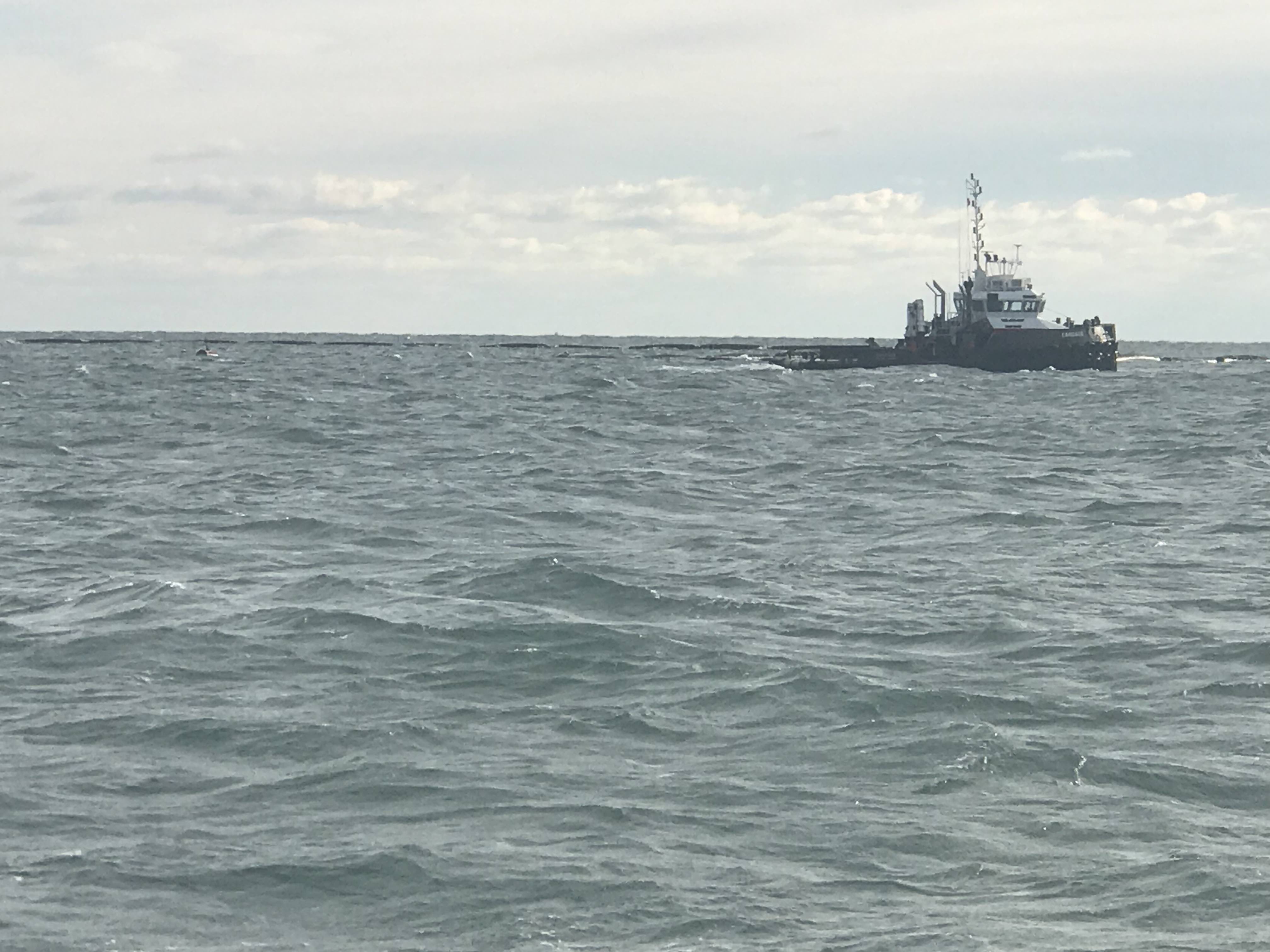
We also passed a fish farm or tug towing a fish pen. You need to be careful of running into these at night.
Tug towing a fish pen
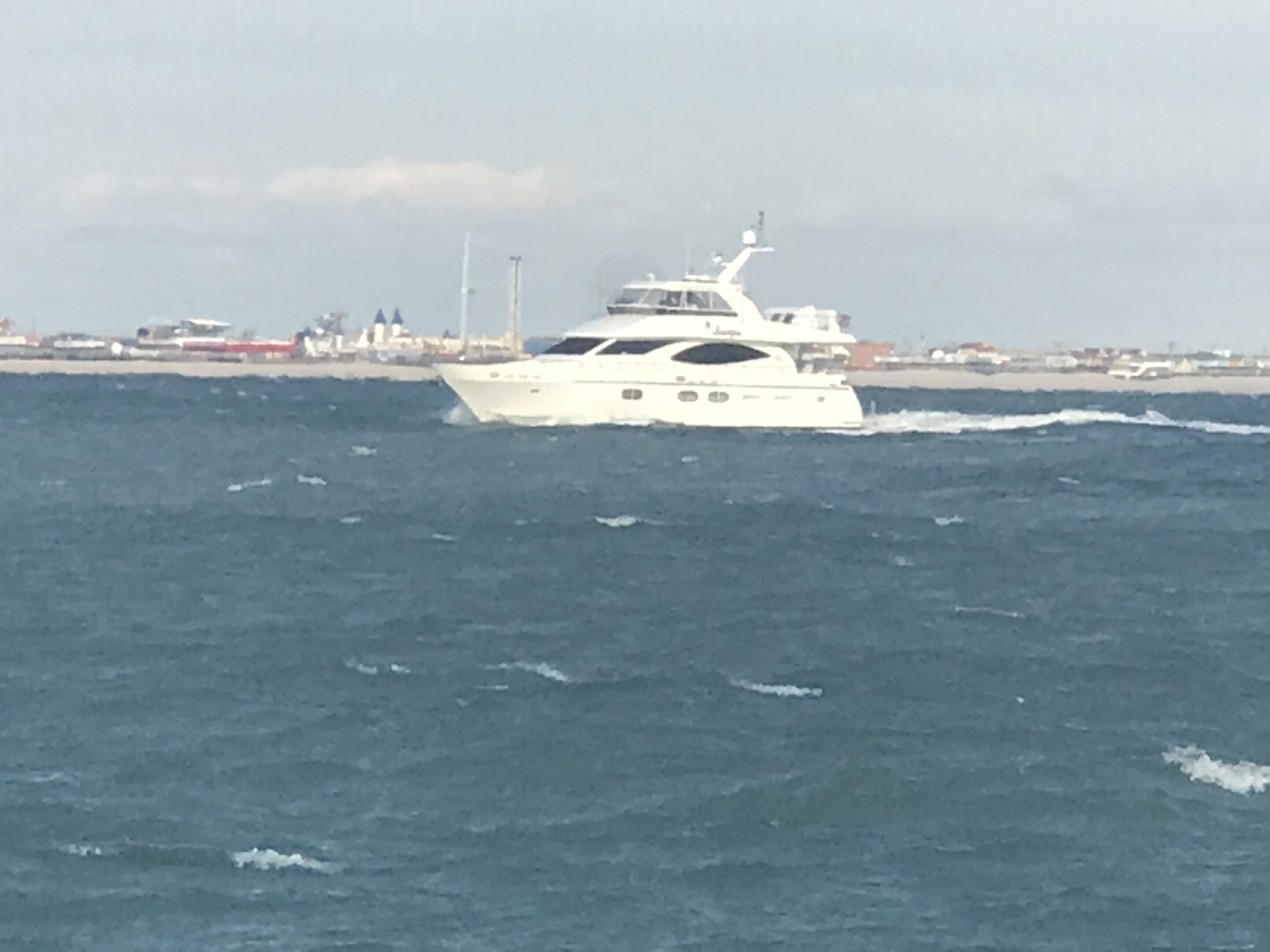
We did see one other snowbird racing south. MV Scorpio passed us doing about 11 kts compared to our 8 kts.
AIS – Automatic Identification System info on MV Scorpio
This drum hazard snuck up on us and we had to adjust course to avoid hitting it. I don’t believe it was lit so keep a good helm watch at night.
Hazard Drum
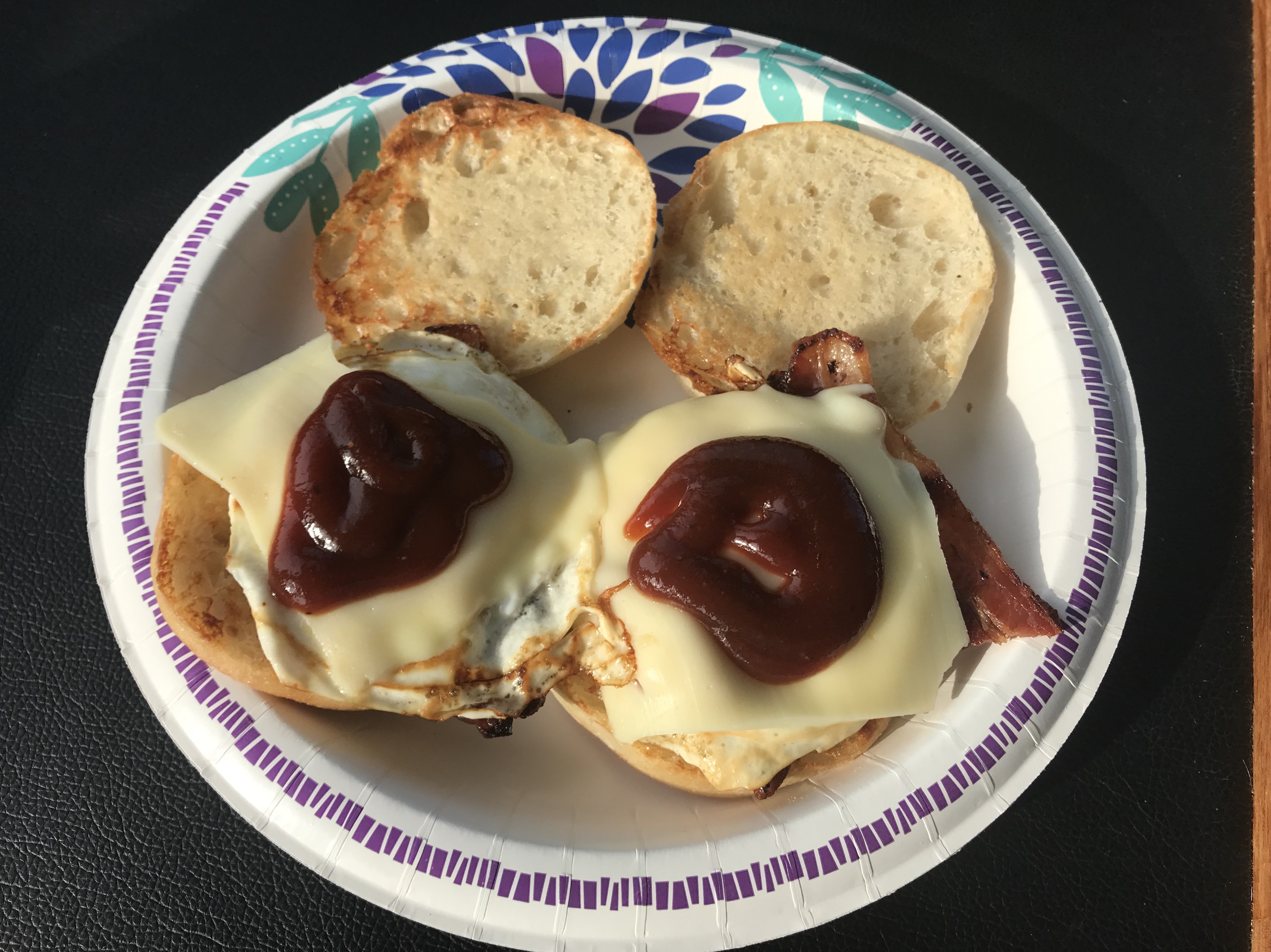
Kelly is great about cooking while underway and delivered two hot bacon, egg & cheese muffin sandwiches to the helm.
Yumm
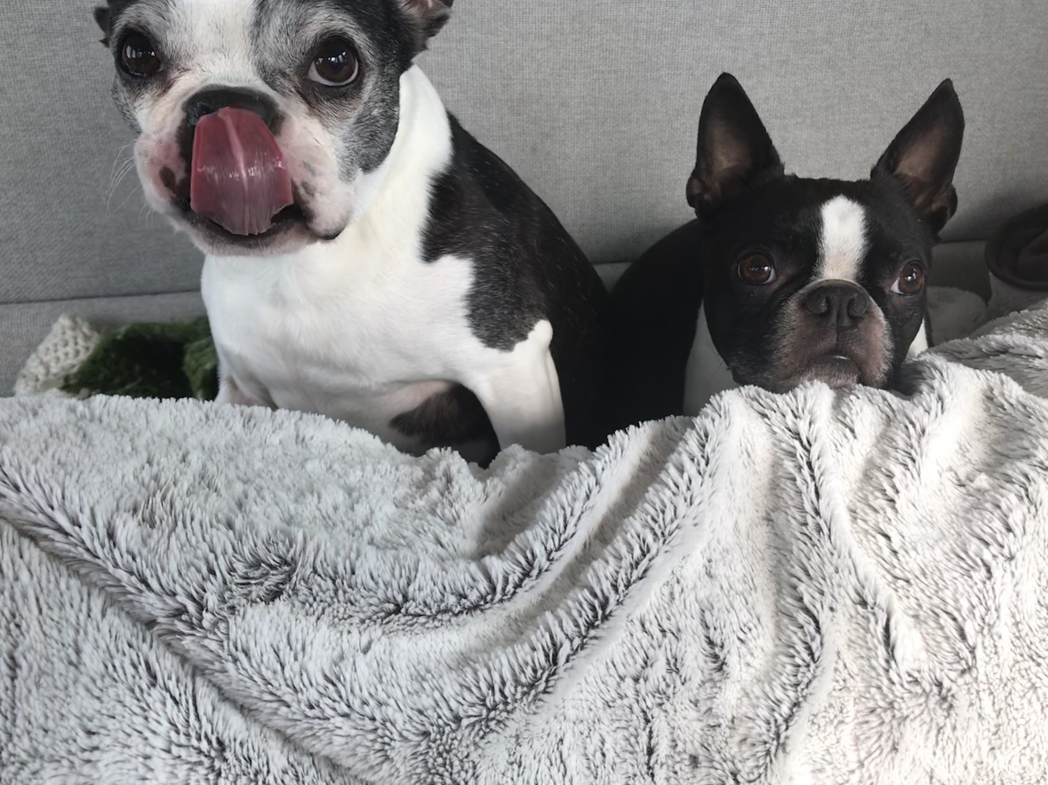
Even the dogs were licking their chops
Happy Smells Maple BACON!!
We passed Atlantic City on our way to Delaware Bay.
Atlantic City
Soon the sun went down and the overcast sky made for a dark night on the water.
We could start to see Cape May on the horizon.
Cape May on the Horizon
When you work your way into the Cape May inlet they provide a nice red range light that you can use to keep your boat positioned in the center of the channel.
Red Range Light
You can see the split in the entrance channel and the range marker right at the split.
My heading line splits right through the range maker
Once in Cape May Harbor we worked our way straight through and out the Cape May canal to Delaware Bay. We anchored for the night just South of the Cape May Canal jetty. A bit of a lumpy anchorage in this wind and chop but we’ll be gone at sunrise as the stormy weather is nipping at our heals.
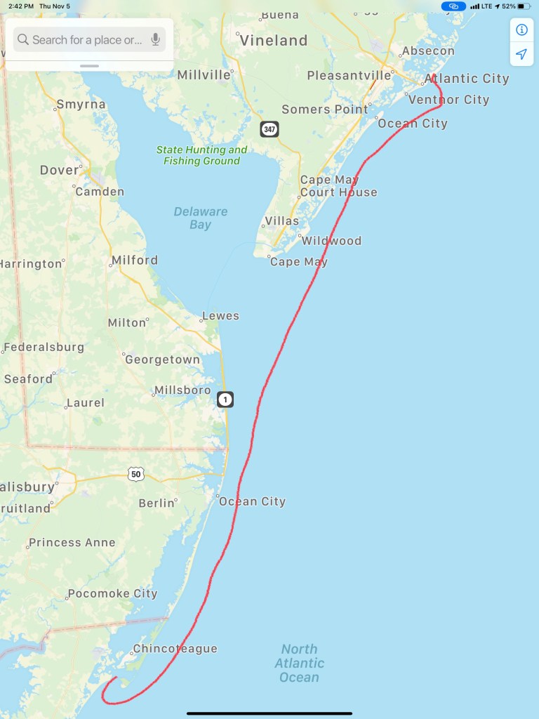
Tomorrow’s forecast has 30-40kt winds were we are anchored tonight.Today’s Leg about 100 miles. W02L004
So we started out of the Manasquan River shortly after sunrise and ran aground before my coffee got cold. The captain was not paying attention as used some excuse about being by the morning sun. “Crappy Captain!” is what we shout whenever I do something stupid. I still have much to learn. It was a sand bar @ 4ft and far from what my charts showed. We backed up and pushed our way off the sandy bar and the rest of the trip was without incident.
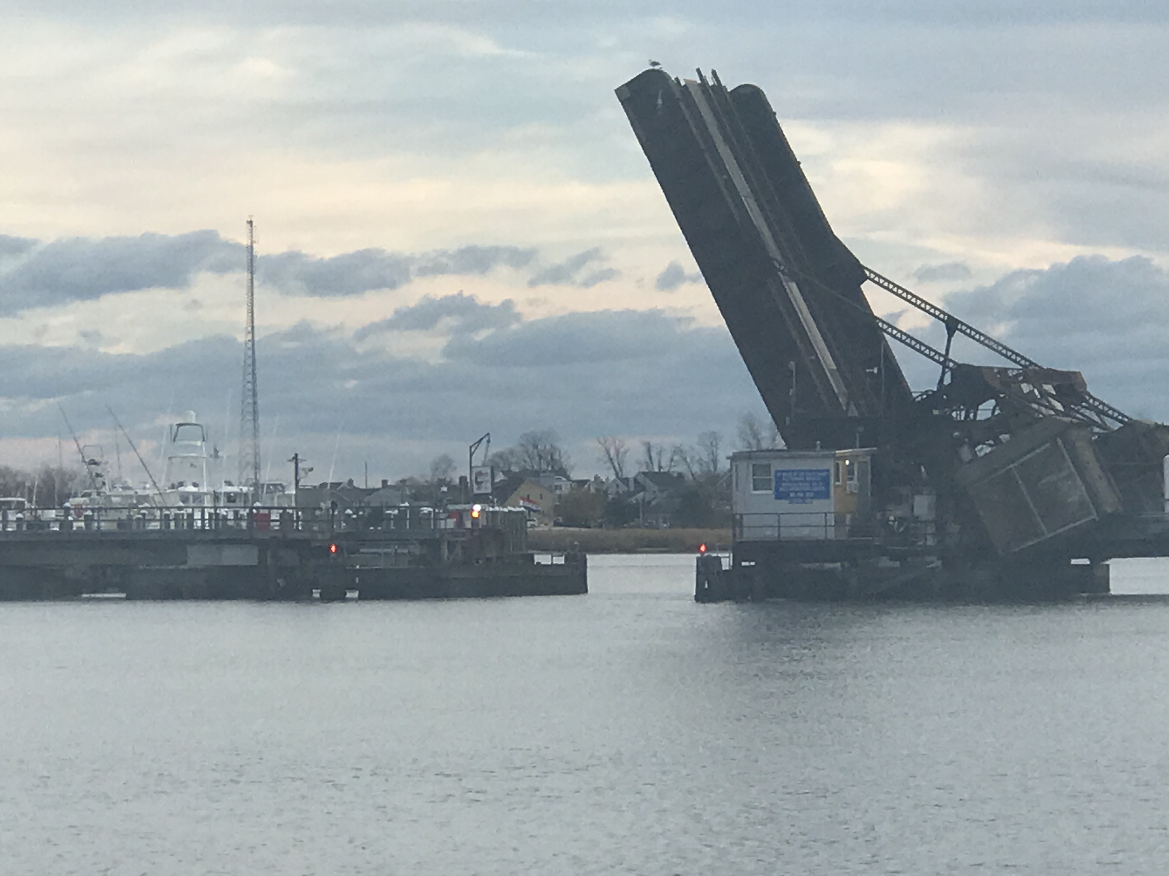
Right away we were forced to wait @ the Manasquan River railroad bridge which was closed for a train crossing. We waited with 20 or so boats for the bascule bridge to reopen. When it did open, it was “every boat for themselves”. It felt like being at the Raynham, MA dog track… “There goes Rusty”. I think that was the rabbit’s name?
As we passed through the narrow opening for the railroad bridge I felt compelled to snap a pic out the pilothouse door to show how tight the passage feels.
Tight Squeeze to Starboard
The last challenge to get through was the Manasquan inlet which was displaying a phenomenon called “reflected waves”. These are wakes from boats (zipping by us) that are being reflected back off the inlet walls. It’s like having your head above water in a washing machine; there is no rhyme or reason to the direction of the waves.
Reflected Waves
The cruise South was smooth as the period between the ocean swell was long, 10 seconds or so. This made for a gentle 3-4 foot swell. We made our way South down the NJ coast and as we passed Atlantic inlets we dodged the many sport fishing boats that were fishing atop of one another. We listened on the VHF as they stood holding a rod on the back of a boat at the end of November.
When it was not fishermen we were seeing it was a porpoise or two. Here is a short video of what I think was a porpoise but I’m sure one of you will chime in about what species owns the dorsal fin in the video?
As we approached, Atlantic City could soon be seen in the distance.
AC Boardwalk
Coming into AC was easy as far as NJ inlets go. With the exception of having to stay clear of the bar that can be understood when you see the breaking waves atop of it.
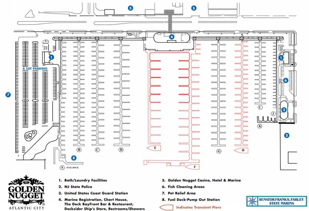
The Absecon Inlet is wide and the ebbing current was only about 1.5 kts against us. Just inside the entrance, we turned to port we left the wind & current behind. As we hailed Farley State Marina and VHF channel 65 as Kelly reminded me to loose my Boston accent and hail “FaRRRley Marina” instead of “Fahlee Marina”. The VHF radio crackled back and they told us to head down the fairway between docks echo and foxtrot and simply pick any slip we liked. We chose a slip close to the Chart House restaurant an 1st mate jumped into action as we backed her down into the slip. Kelly great about waiting till I bring the boat alongside the floating dock before attempting to jump off onto the dock. A miscalculation could lead to winding up in the water between the dock and the 30,000 lb boat as it kisses the dock. This docking however was easy-peezee. The wind was buffeted by the highrise hotel and dockside current was zero.
1st Mate Kelly
We tied up quickly and raised a toast to AC. Thankfully the night before I had walked the path from the boat, under the bridge and to the liquor store to buy MORE IPA beer. I learned beer is always a mix of malty barley vs. bitter hops. Like all IPA enthusiasts, the more bitter the better. My IPA of choice is a “West Coast” style IPA that has IBU (International Bitterness Units) between 50-100 and with a citrus pop like grapefruit or mango, etc. Anyway… the liquor store had Stone Brewing’s “Delicious” IPA and I have to say…YUMMMM, what a great IPA.
YuMM
As for Atlantic City, well… we were starving and decided to go to the Chart House.
Atlantic City Water Club
The Chart House was great. We caught happy hour and it was Capt & margaritas! & filet & fish tacos.
We are planning a sunrise departure again but I convinced Kelly to do a quick Casino tour. Thirty feet into the casino and the cigarette smoke made us change our minds. Tonight we’ll finish happy hour on the boat while I write this blog update and do some chart plotting before bed.
Tonight I will be scouring every maritime website / app for any & all information I can about the Delaware coast. Today’s Captain is digital. It used to be an old guy who looked like the Gorton fisherman but now it’s a millennial with the charting, piloting, tide, moon phases, sunrise times and weather apps on multiple digital devices.
Gorton vs. Millennials
Though I must admit…a captain is only as good as his/her experience. I have been boating 20+ years and still feel like a noob at times. I imagine that becoming a full-time cruiser will give me the time to read such maritime tomes as Chapman Piloting and Bowditch – The American Practical Navigator.
Every captain make mistakes… which we’ll call wisdom later on 😉
That’s all for now. Kelly & I hope everyone had a great Thanksgiving.
We are still here at Crystal Point Marina in Point Pleasant, NJ. It’s a rainy day – perfect for writing a blog update.
Rainy Day in the Pilothouse
Correction, I think the marina’s official address is in Brick, NJ but it’s right on the town line. While we wait I am catching up on “The Walking Dead” and “Mr. Robot” while Kelly is watching “Blue Bloods”.
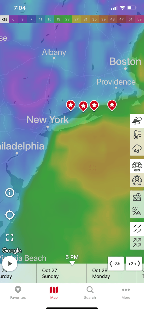
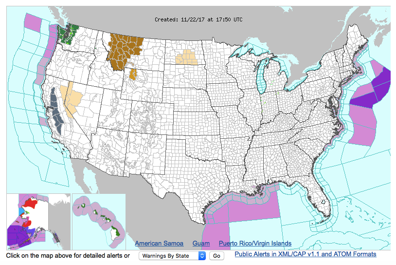
We are waiting for a weather window to proceed south to the next leg of our journey – Atlantic City, NJ. The NWS Marine Weather Forecast is showing Friday @sunrise to be our best bet.
FORECAST FOR COASTAL WATERS FROM MANASQUAN INLET TO LITTLE EGG INLET NJ OUT 20 NM
If you want to feel like you are on the water with your VHF radio tuned to the WX channels (first 5 or so channels on a VHF Marine Radio) check out this live stream of the Tom’s River NWR Station
NOAA Weather Radio Frequencies
162.400 MHz (WX2)
162.425 MHz (WX4)
162.450 MHz (WX5)
162.475 MHz (WX3)
162.500 MHz (WX6)
162.525 MHz (WX7)
162.550 MHz (WX1)
Channel numbers, e.g. (WX1, WX2) etc. have no special significance but are often designated this way in consumer equipment. Other channel numbering schemes are also prevalent.
I feel like all the other “Snowbirds” have left before us and I am like the main character of the book my mother would read to me, “The Poky Little Puppy”. She would joke that I was a “lollygagger”. I suppose it’s my right as the last-born.
Snowbirds go south and there is more than one route to take. If you have a “Blue Water” boat and enjoy open ocean you may simply wait for a weather window and set a rhumb line straight from Newport, RI to Bermuda. This route is what the sailors of the bi-annual Newport to Bermuda sailboat race take. From Bermuda, its due South straight to St. Thomas in the Caribbean.
Rhumb line from Newport, RI to Bermuda
Caribbean Route Options
This route is only taken by larger sailing vessels and long-range stabilized trawlers such as a “Nordhavn”. Speaking of Nordhavn Yachts… in 2011, I flew down to Jacksonville, FL to purchase a Nordhavn 43. The marine broker met me at the boat which was “priced right” but as soon as I toured the vessel it was clear that she had not been properly maintained. Maybe in the future?
Nordhavn 43 Raised Pilothouse
While we initially looked at buying a blue water trawler we realized that it did not match the type of cruising that we would be doing. We settled on a long-range trawler that was perfect for the kind of coastal cruising that we do. Coastal cruising means that you generally cruise from one port to the next never exceeding 10-12 hours at the helm. Blue water cruising means 24-7 motion with 3 hours “watches” while the other crew are sleeping in their bunks. We settled on a North Pacific Yachts 43 (45 LOA) with a raised pilothouse design and many options that we hand selected. I will save the details for an upcoming blog post about the boat itself.
Weather:
When you become a full-time cruiser you start to focus your efforts on learning more about weather. You find yourself spending a lot of time on the NWS (National Weather Service) Marine Weather Forecast website learning about all the information that it can give you. Not just forecasts but real-time observations from ships and weather buoys.
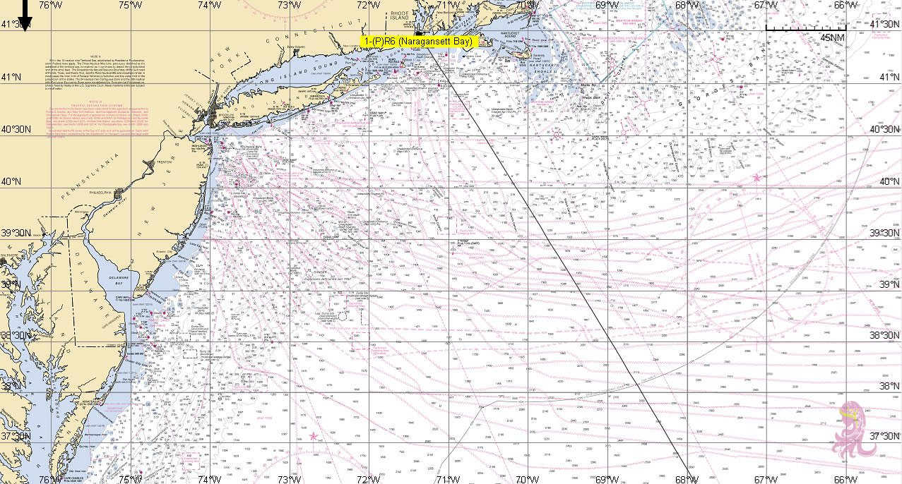
Map showing the different weather “zones” – use link below for clickable version
from the link above, you can select from a graphical map, the coastal forecast for the “zone” that you are in. The coastal forecasts are broken up into small rectangular sections of coastal waters that are roughly 20 miles on most sides. There is an offshore forecast for fisherman who fish the “Canyons” which are the deep underwater valleys that you see when you look at a bathymetric chart that shows the underwater topology (sea mounts and valleys).
Canyons South of Block Island and Nantucket
There are also inshore forecasts as well that show the weather inside the bays. I have always had a keen interest in meteorology and understanding weather. I was smitten with weather the very first time a meteorologist came to give a lecture at UMB (Umass/Boston) and I swear every other term I needed to lookup the meaning. More recently, I signed up for a 2-day “Marine Weather Workshop” at the annual Newport RI Boat Show. I imagined that the class was going to talk about how to read the weather by looking at the skies around the boat. I was thrilled when it turned out to be a much more science based talk about wet & dry adiabatic charts and surface pressure charts built from daily weather balloon launches, etc.
The presenter was Lee Chesneau and you can find his Marine weather page here.
I’ll post more about weather as we go and maybe spend some time talking about the many different aspects of understanding weather. For now, my plan is to shelter-in-place (unfortunately, that word has a more recent meaning) and wait for the northerly winds that often follow a cold front.


You must be logged in to post a comment.