A Journey of a Thousand Miles Begins with One Step

Just Don’t Be Late

Simple Life was supposed to leave the dock on Saturday, October 17th. Now, two weeks later, it’s Halloween and Preppy and I are out on the bow in the blowing snow trying to wire up a windlass.

Windlass wiring

It’s Cold!

Our hands are barely working after letting go of the freezing cold anchor chain. We laugh at how ridiculous the situation is.

It’s says it’s 34 degrees and snowing but the raw wind definitely does make it feel like 22 degrees.

Snow! It’s everywhere.

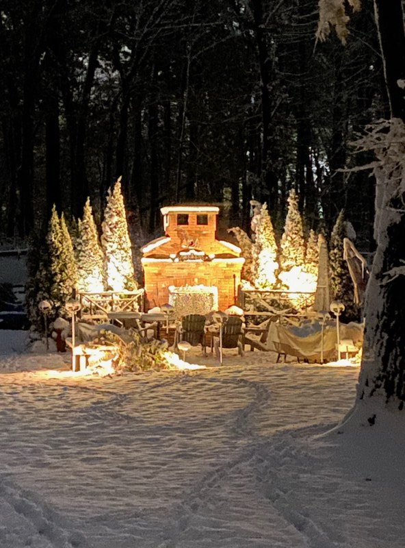
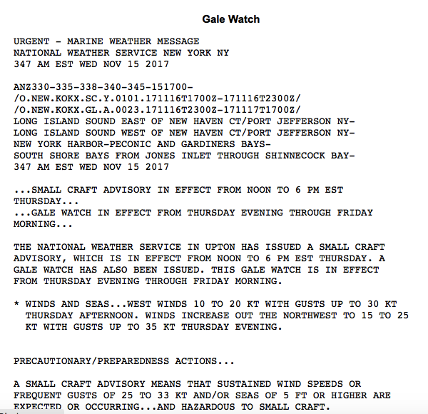
The original departure date was missed but with Preppy aboard we were now ready to depart. Another quick check of the weather and there’s the remnants of a hurricane that are blanketing our area.
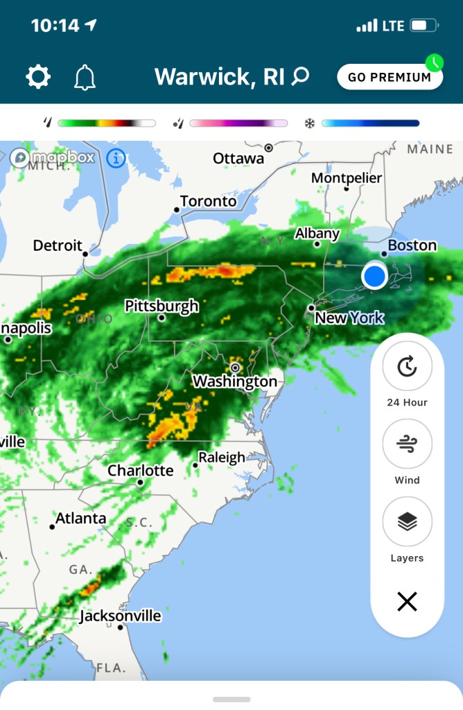
Storm Radar

Gale Warning

So we give it a couple days and what’s next? A Gale Warning!
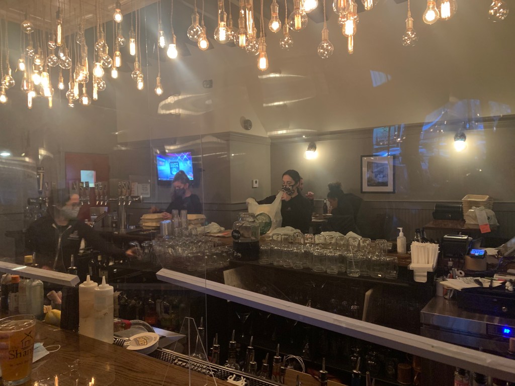
Not the forecast I was hoping for

The Shanty

With nothing to do but wait we decide to walk to The Shanty for dinner and some IPAs .

The Shanty for some IPA

Frozen Dock Lines

It’s Halloween morning and Preppy is going home as he has next week’s jobs to prepare for. Preppy had agreed to make the trip over to the fuel dock in the morning before we parted ways. The only challenge now was getting off the dock?

Me attempting to thaw my dock lines

Sometimes I don’t think… I just do. So when Preppy said the dock lines are frozen solid on the cleat, I just grabbed the torch which was right next to me and started heating them up. It was not until Preppy said … Umm.. why don’t we just pour some hot water over them? Duh? Yes, that did the trick!

With the dock lines finally freed we made our way out of the slip and over to the fuel dock.

Preppy finally freed the frozen lines

At the fuel dock were Peter & Leslie of MV Leap of Faith. They were attempting to use the pumpout hose but it was frozen and would not operate. MV Leap of Faith is also heading south for the winter. They travel faster than I do so we’ll stay in touch as we go through text & calls.

I really like leaving with full water tanks and an empty blackwater tank, especially when it’s cold as I’ve run into situations where you try to pull into a marina to get water & pumpout and it’s either frozen or winterized. I spent quite a while with the pumpout hose locked open and in the seawater till it thawed and came to life writhing like a snake. A short suck of the 54 degree seawater and it was time to pump out.

The water in Greenwich Bay is a chilly 54 degrees

The Lookback

As I pulled away from the fuel dock, I looked back. Every time I leave I look back. There is an undeniable feeling of freedom. It’s the first moments of a 6 month, 5K mile journey. I smile. The world seems right.

Snow covered fly deck looking back at fuel dock

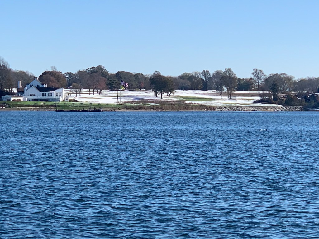
As I pass Warwick Neck I can see the snow covered Warwick Country Club.

snow covered Warwick Country Club

Point Judith

MV Leap of Faith had already called me and gave me the word that the sea was very calm when they exited Narragansett Bay. I was passing Point Judith Light and slowing coming up on a Hunter sailboat who was also enjoying the trip west down Long Island Sound.

At this moment I noticed that my Garmin satellite tracker seemed frozen. I checked my blog’s current position page and it showed that I was still in Warwick, RI? I quick reset of the satellite tracker and it update my position. Ofcourse it drew a straight line between where I left and where I was when the tracker came back to life. I’m guessing someone is going to ask me how I piloted the boat over the state of RI?
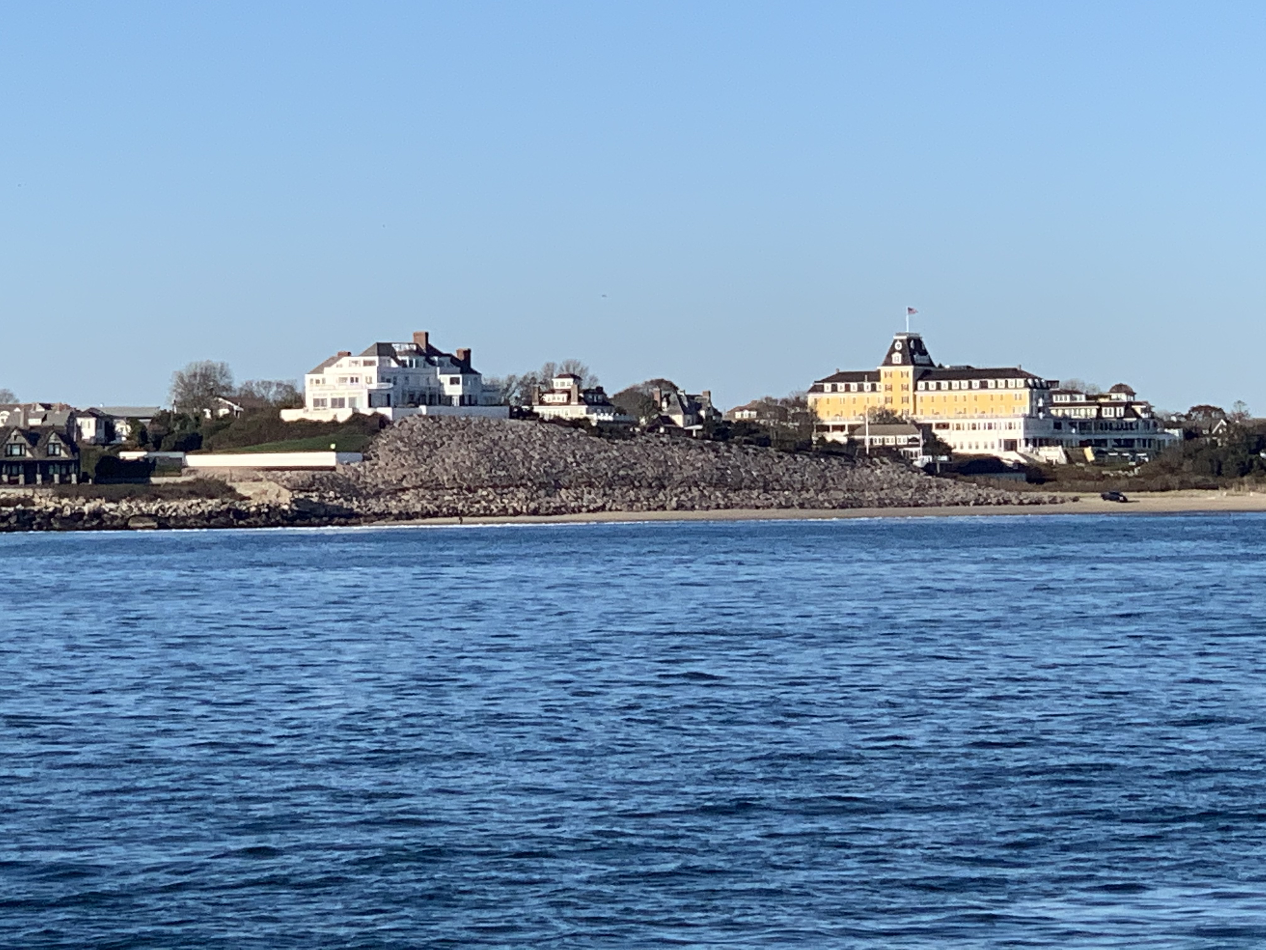
Watch Hill

Soon I was passing Watch Hill, RI and some of the beautiful homes along the coast.

Fisher’s Island

I made my way up the inside of Fisher’s Island. There were fishermen working the current between the island and mainland CT.

Fishing the rip

I don’t know a lot about Fisher’s Island but it looks beautiful as you cruise past.

On the west side of Fisher’s Island you must keep an eye out for the ferry’s as they can sneak up on you pretty fast.

Cross Sound Ferry MV John H – between Orient Point, Long Island, New York and New London, CT

I had planned to anchor behind Fisher’s Island because I had never done that. However, the sea was calm and the moon was bright. I decided to keep going west. The area around Fisher’s Island is called “The Race” and it has strong currents and often gets pretty choppy. Getting inside the northern fork of Long Island seemed like the right thing to do.

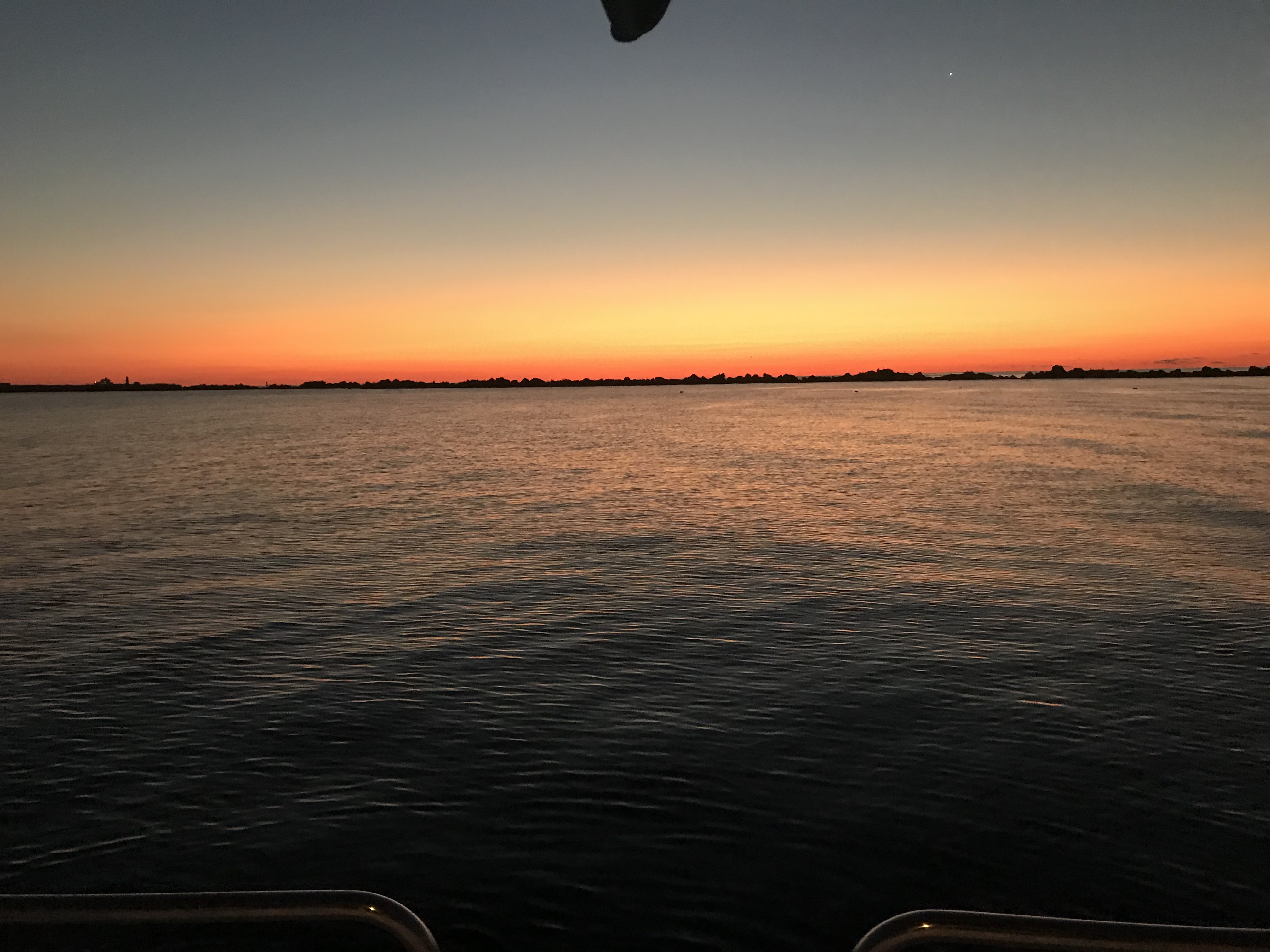
With the sun setting Long Island Sound looked amazing.

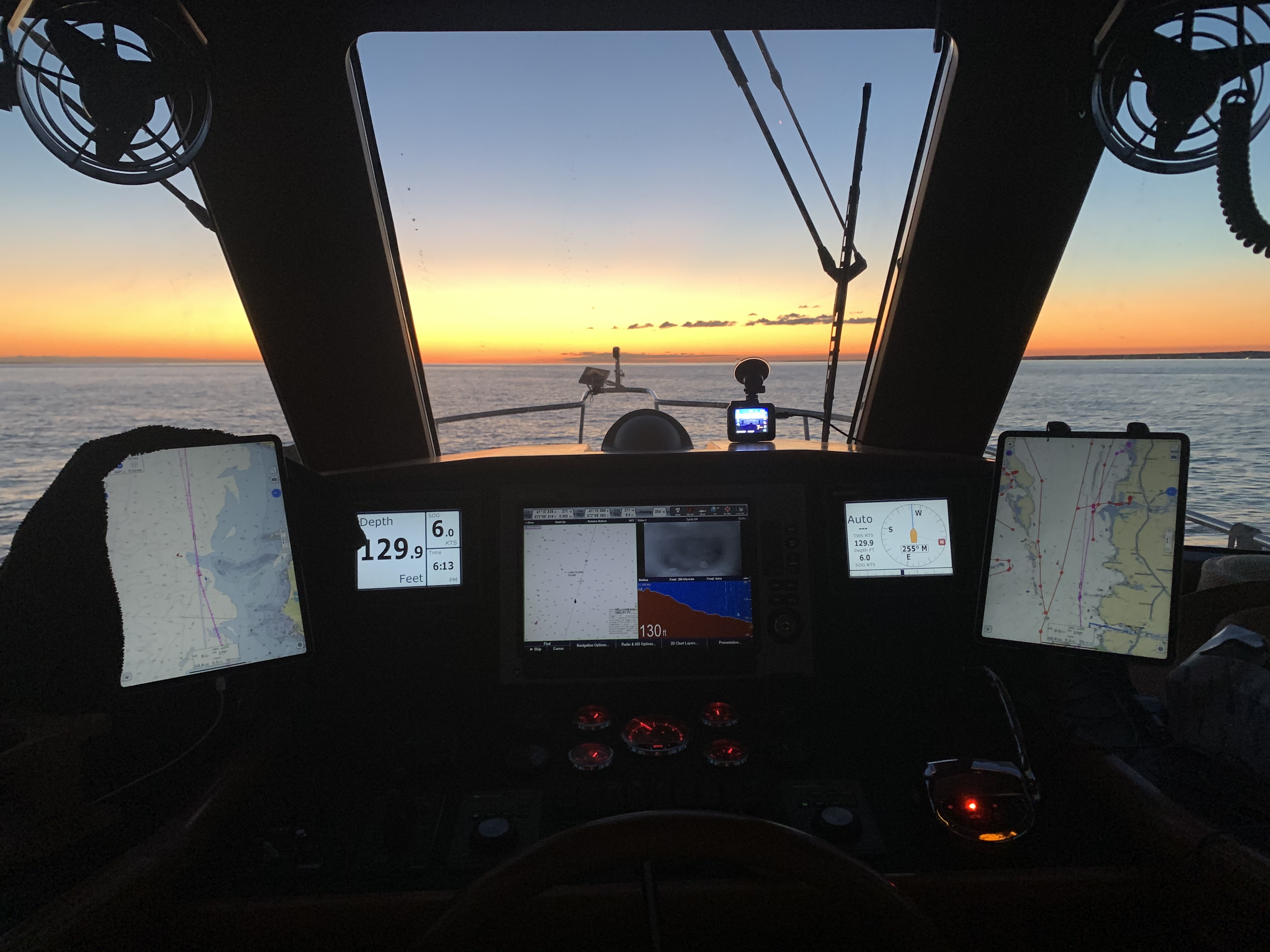
As night settled in around me I flicked my running lights on and settled back in the captain’s chair for a long night.

Nighttime at the helm

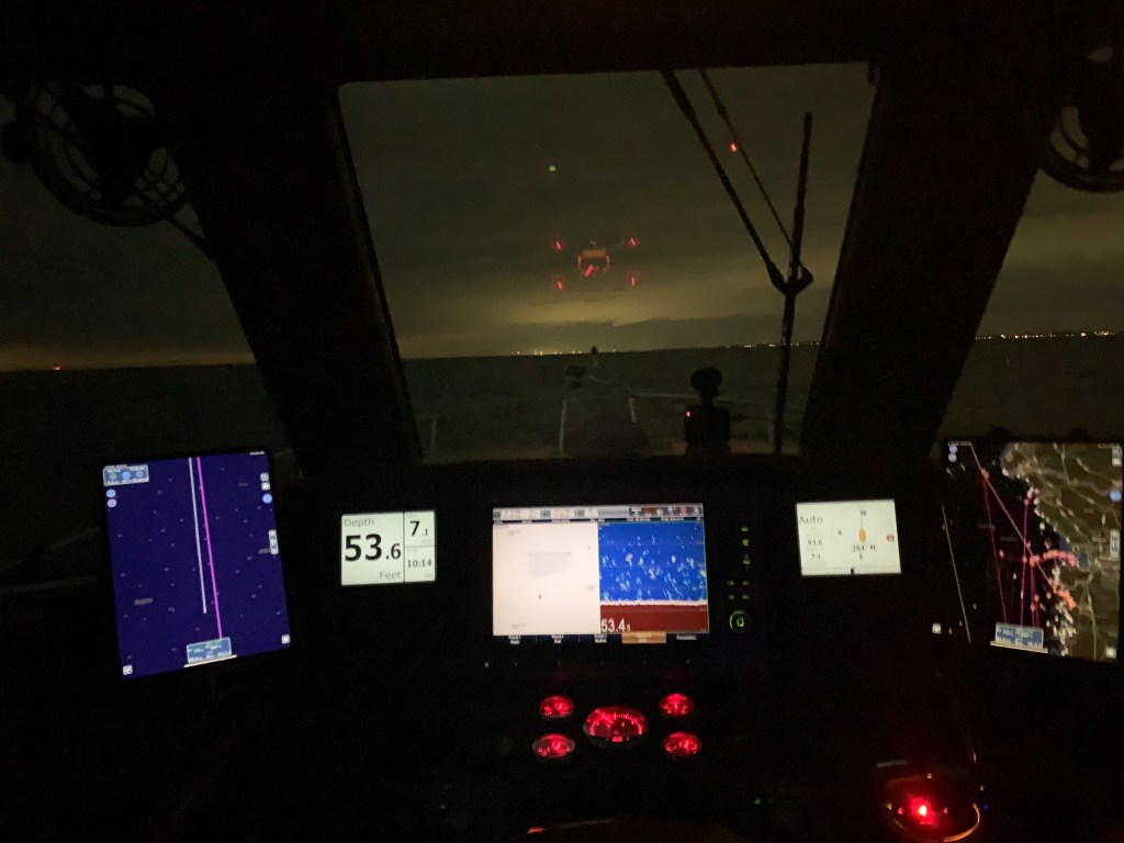
Ultimately I settled on an anchorage with only minimal protection but “just off the beaten path” as they say. Not to far inland that it takes an hour to get in and an hour the next morning just to get out.

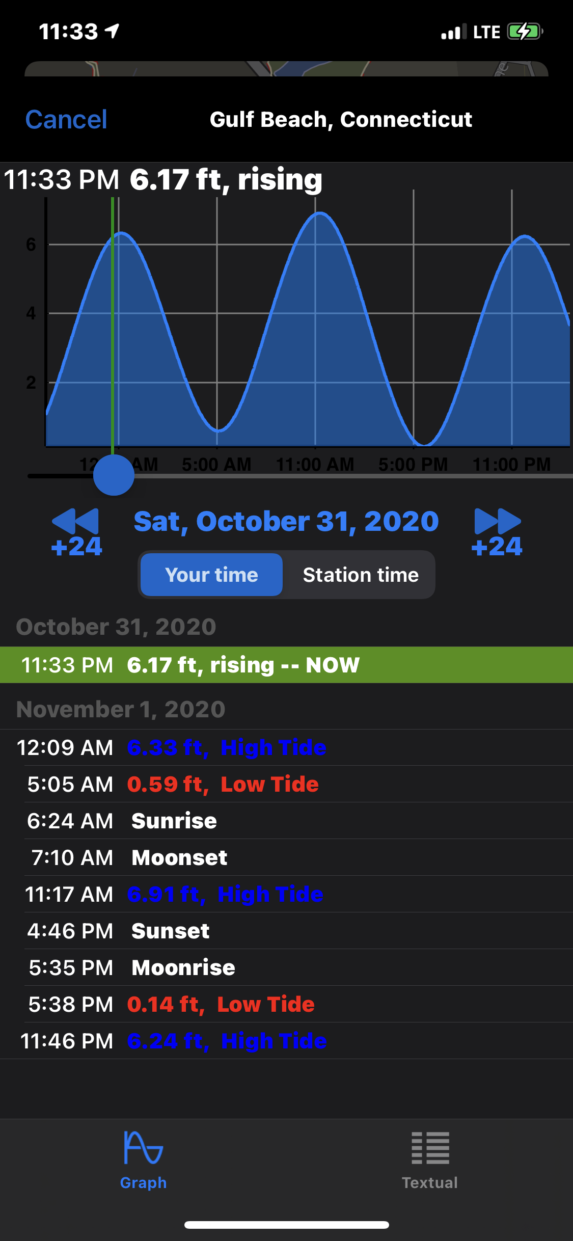
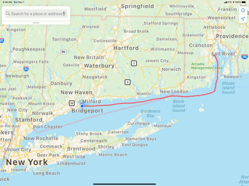
I anchored just off Fort Trumbull Beach in Milford Harbor. This location is just west of Bridgeport, CT. There is a small island called, Charles Island with a low-tide land bridge. You need to watch your tides down here near the head of Long Island Sound. If you anchor at high tide you might wake up at low tide with the boat resting on the bottom.

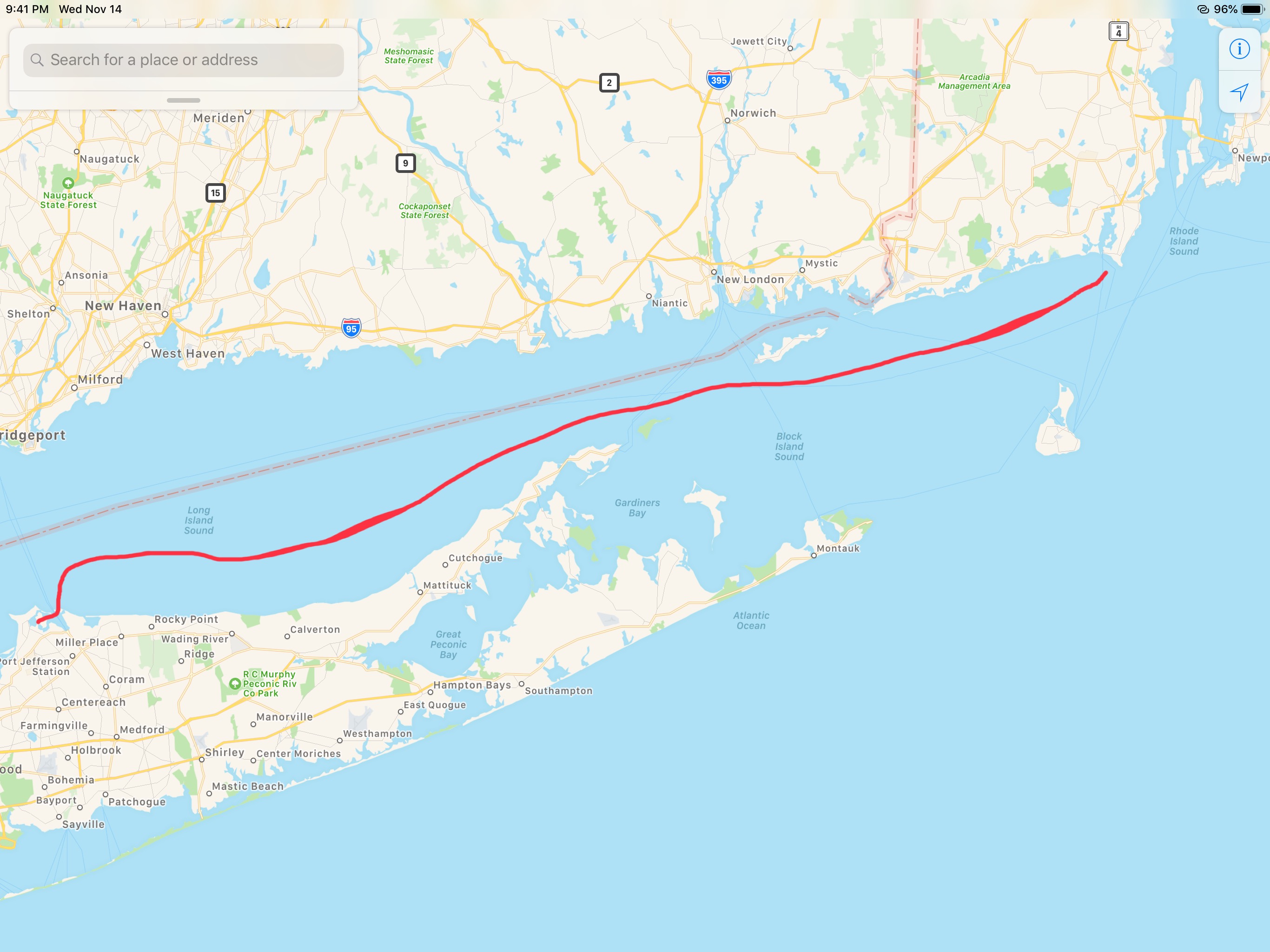
The time was now midnight. It had left Warwick, RI at around 10AM so roughly 14 hours to Bridgeport, CT. The 1st 98NM leg of my Winter 2020 journey looked something like this.

W04L001 – Winter #04 – Leg 001

It was around 1AM by the time I took a hot shower and got to bed. I’m typing this blog post as I sit in the captain’s chair navigating leg 2 of my journey. Stay tuned for the Leg 2 post.

Port Jefferson Long Island – in the Dark

We left Point Judith just before sunrise.

Along the way the sun came up in the East and since we were heading due West it was directly on our stern.

The boat was running great and it was time to drop the throttle to the pins and see what she’ll run at. I had hoped that she would reach WOT of 2800 but alas we only hit 2700. Proof that the boat is running a bit heavy and we may need to re-pitch the prop in the Spring. I almost did it this Fall but with the moving the ballast around I figured she may run a bit different at WoT (Wide Open Throttle).

2700 RPM ain’t 2800 and maybe re-pitching the prop will fix that.

Along the way we got a “low voltage” alarm at the helm and after troubleshooting it it turned out to be the VSR (Voltage Sensititive Relay) that was not working properly. When you have a boat with 3 battery banks and 2 charging methods (alternator on the diesel & shore power battery charger) you need a VSR that combine the battery banks when there is a charging source (above 13V) and something that disconects the battery bank from the others when it drops below 12V. By isolating the battery bank you prevent all the battery banks from being depleted while allowing a single or multiple sources to charge all the battery banks at once.

Cockpit lazarette power panel. Two VSRs and 3 battery banks.

Anyway.. long story short our VSR was not combining the battery banks and I could use a manual override to force the diesel alternator to charge not just the single 8D battery for the diesel but also the Qnty 3 8D AGM (Acid Gas Mat) house batteries.

By the way. I just replaced those batteries at 160lbs a piece. I needed to be a bit younger. I’m not as strong as I was….

W02L02 (Winter 02, Leg 002) looked something like this…

OK that does not include our nighttime arrival into Port Jefferson, NY (in Long Island).

Even funnier were the dogs. They get nervous when the sea starts to get rough. That said the sea state was smooth but they were just out of practice. Chief Martin Brody was a bit nervous so by sitting on his big sister makes him relax. I’m not sure Happy agrees with this …

That’s all for tonight… I’ve been following the weather and it’s forcing us to run 12 hours days into the night to stay ahead of the NorEasters that are bringing high winds and heavy seas. We just need to get South down the Jersey coast before the Gale Force Wind warnings that are so commonplace during a NE winter…

We are anchored until sunrise @6:38AM on Tuesday. Until then.. this is our view of Port Jefferson..

W02L002 – Leg #2 From Point Judith, RI to Port Jefferson, NY

The Winds of November Came Early

We left Morris Cove Anchorage at 5:30AM. It was dark, very dark. We had woken up around 4 AM.  I had pulled up the anchor, spun the boat around and MV Simple Life started going bow up, bow down.  I thought… the winds were not supposed to increase until Thursday afternoon (per the NWS – National Weather Service Gale Warning).  In the words of Gordon Lightfoot, “The winds of November came early”. We used our searchlight to spot the buoys on our way out of New Haven Harbor’s channel.

Jay Marques, you asked for video in addition to photos so these links are for you.

Leaving Morris Cove Anchorage – Low Light

Sorry, that video is the lightest of the three I recorded. With the winds out of the south it meant that the 16 mile fetch of water from the NY side to the CT side was making the CT side of the sound lumpy. I heard the VHF radio crackle alive with a tugboat captain complaining that the winds had been honking all night long. Here is a video after the sun came up and we were slogging our way South across Long Island Sound from New Haven, CT to Long Island’s Huntington Bay area.

Slogging our way South Across LIS

When Kelly & I first met I had a 1998 35′ Beneteau 352 Oceanis ,S/V Saltyhacker, (I’ll upload a pic of SV Saltyhacker later) that had only a dodger (the see-thru plastic and canvas that covers the companionway opening into the boat. We sold her to a great couple from Canada and bought a 2001 45′ Hunter 450 Center Cockpit. (I’ll upload a pick of SV Skull & Swords later, promise). The Hunter was owned by friends of ours who were living aboard her in Exuma Key, Bahamas and ever since we’ve said someday we’ll spend a few months on anchor there.  We loved the Hunter for it’s liveaboardness;  for it’s fully enclosed cockpit and interior space but Kelly would often quip that unless we are sitting in the outside cockpit you don’t get to enjoy the scenery. So we decided to buy a new boat that met our mutual demands. Kelly wanted a boat that was easier to move around in (Kelly has a habit of twisting / breaking ankles when underway or simply aboard). After spending 10 hour days at the helm outside and often cold, I was fancy on an enclosed pilot house. In the video above you will just have to imagine as the cold sea spray is hitting the pilothouse windows that I’m sipping my coffee in my PJs at the helm (smile).

Todays trip looked something like this..

Leg3

As you approach the East-end of LIS you enter into the East River that takes you from the Bronx to the Statue of Liberty. As many times as we have made this trip we still find ourselves taking pictures of the scenery as we go down the river. Below are some of the photos we snapped along the way…

Prison
After going by Riker’s Island Jail you pass the Vernon C. Bain Correctional Center. This is a 47,000-ton, five-story barge with 800 beds spread over 16 “dormitories” and 100 proper jail cells. At 625 feet in length and 125 feet wide, it also holds a gym, a basketball court, a library, three chapels, a rooftop exercise area

Broklyn Bridge
Brooklyn Bridge – built in 1870

Helicopter
Whirly Birds buzz the East River and land just North of Battery March

Water Taxi
Water Taxis are everywhere and as a captain you must be alert and ready to dodge them

We timed our trip down the East River to make sure we caught favorable currents that saved us easily an hour during our transit. After arriving in NYC harbor we hailed Liberty Landing Marina and requested our slip assignment. The wind was gusting but an attendant met us at the slip and caught the lines that 1st Mate Kelly threw to him.

LibertyLandingMarina
MV Simple Life tied off at Liberty Landing Marina

Tomorrow we’ll take the water taxi and find somewhere to grab a IPA & Capt-Pepsi -NFL (No-Flipping-Lime) & a bite. Tonight we’ll just relax 😉

New Haven CT & Gale Warnings

PtJudithSunrise2
Pt. Judith, RI – Harbor of Refuge @ Sunrise

We departed Harbor of Refuge @ sunrise this morning. We felt a sense of urgency due to a gale warning (gusts to 35 knots) which is in effect beginning Thursday afternoon. The cause is two separate low pressures that are having a complex interaction West of our current location.


GaleWatch
NWS Gale Warning NYC

Below is a rough depiction of our second leg of our journey South. Our course took us from Pt. Judith’s Harbor of Refuge, outside Fishers Island to Morris Cove Anchorage in New Haven, CT.

Leg2
Leg #2 of #Run2Sun2017

Today’s cruise was long but relaxing. The sun was streaming in windows making the pilothouse warm as we made way @ 8.5kts West down Long Island Sound.

We saw only a few sport fishing boats and had to dodge the occasional ferry crossing our path.

Ferry
Ferry Crossing Long Island Sound

Every captain knows it’s better to take the stern of larger vessels rather than attempt to cross her bow. Ten or so years ago I had a close with a US battleship @3AM in pea-soup fog in Norfolk, Virginia’s entrance channel. Our close call was not a crossing issue but instead the warship was inbound in the channel and was not basting fog signals. After they suddenly appeared on radar from under the Chesapeake Bay bridge/tunnel we quickly blasted our horn. When they responded with their horn I swear my ears blew out. The warship quickly passed us not 100′ off our port beam (frightening in the fog). A shout out to that day’s offshore crew – Eddie, Sean and Amy who can attest to this poop-your-pants experience.

warship
Stay Clear of Warships

Kahlenberg Air Horns

After this harrowing experience, we installed Kahlenberg triple trumpet air horns as well as AIS (Automatic Identification System) in Simple Life.

AIS
How AIS Works


AIS equipped vessels can each view on their chart plotter the other’s vessel name, size, speed, heading and course-magnetic. AIS works by sending & receiving digital data over VHF channel 70 so that two ships can see each other on their chartplotter screens even without radar. I  have also learned to that programming your marine VHF with a MMSI # make ship2ship communications easier when it’s dark or foggy.


Hells Gate
Hell’s Gate Current Table

Tomorrow our plan is to push west down the coast of Connecticut with hopes of catching the 4.8kt ebb tide through the East River (where the dead bodies are found on many Law & Order episodes). Kelly & I always enjoy the East River’s Hell’s Gate (where the Harlem River meets the East River). Hell’s Gate is infamous due to the strong currents that mix in the way a washing machine mixes water.

We hope to make the Liberty Island Marina in Jersey City by sunset on Thursday. We’ll spend two nights at the marina while we wait for more favorable weather for our trip down the Jersey coast. Until then we’ll just sit on anchor watching the lights from New Haven.

New Haven at Night
Lights of New Haven as seen from Morris Cove